All images are copyright! If you wish to purchase any images for commercial use, please contact me via the Contactpage.
About taste2travel!
Hi! My name is Darren McLean, the owner of taste2travel.
I’ve been travelling the world for 36 years and, 225 countries and territories, and seven continents later, I’m still on the road.
Taste2travel offers travel information for destinations around the world, specialising in those that are remote and seldom visited. I hope you enjoy my content!
Ever since I was a child, I have been obsessed with the idea of travel. I started planning my first overseas trip at the age of 19 and departed Australia soon after my 20th birthday. Many years later, I’m still on the road.
In 2016, I decided to document and share my journeys and photography with a wider audience and so, taste2travel.com was born.
My aim is to create useful, usable travel guides/ reports on destinations I have visited. My reports are very comprehensive and detailed as I believe more information is better than less. They are best suited to those planning a journey to a particular destination.
Many of the destinations featured on my website are far off the regular beaten tourist trail. Often, these countries are hidden gems which remain undiscovered, mostly because they are remote and difficult to reach. I enjoy exploring and showcasing these ‘off-the-radar’ destinations, which will, hopefully, inspire others to plan their own adventure to a far-flung corner of the planet.
I’m also a fan of travel trivia and if you are too, you’ll find plenty of travel quizzes on the site.
Photography has always been a passion and all the photos appearing in these galleries were taken by me.
If you have any questions or queries, please contact me via the contact page.
Test your knowledge with this Asia travel quiz from taste2travel.
How well will you score? Your result will be displayed at the bottom of the quiz – will you get to see the legendary Marco Polo?
Good luck!
01. Which is the capital of Turkmenistan?
Correct!Wrong!
02. Which is the currency of Iran?
Correct!Wrong!
03. The Hindu Kush mountain range is located in which countries?
Correct!Wrong!
04. How many countries are there in Asia?
Correct!Wrong!
05. In which country would you be if you were viewing Big Almaty Lake?
Correct!Wrong!
06. This is the currency of which country?
Correct!Wrong!
07. Which is the capital of Timor-Leste?
Correct!Wrong!
08. The Musandam Peninsula is a part of which country?
Correct!Wrong!
09. This is the flag of which Asian country?
Correct!Wrong!
10. Which is the currency of Tajikistan?
Correct!Wrong!
11. Which is the principal religion of the Indonesian island of Bali?
Correct!Wrong!
12. Persepolis, a UNESCO World Heritage Site, is located in which country?
Correct!Wrong!
13. Which is the capital of the Maldives?
Correct!Wrong!
14. This is the flag of which Asian country?
Correct!Wrong!
15. Which is the currency of Vietnam?
Correct!Wrong!
16. The beaches on the west coast of Thailand are located on which body of water?
Correct!Wrong!
17. The demilitarised zone (DMZ), which demarcates North Korea from South Korea, is located on which parallel?
Correct!Wrong!
18. Which is the capital of Kyrgyzstan?
Correct!Wrong!
19. Which is the currency of the Philippines?
Correct!Wrong!
20. This is the flag of which Asian country?
Correct!Wrong!
Travel Quiz 61: Asia Travel Quiz
Sorry! You scored less than 50%. Why not try one of the other taste2travel trivia quizzes?
You scored almost 75%! Why not try one of the other taste2travel trivia quizzes?
Very Good - a gold star performance! Why not try one of the other taste2travel trivia quizzes?
Excellent result! You're a modern day Marco Polo! Please feel free to blitz my many other quizzes on taste2travel!
Share your Results:
Travel Quizzes on taste2travel
Welcome to taste2travel!
My name is Darren McLean, I’m the owner of taste2travel and I love travel trivia and I certainly enjoy creating travel quizzes.
There are a total of 80 different travel quizzes on taste2travel, with each quiz containing 20 questions.
That’s a total of 1,600 trivia questions waiting to challenge you.
You’ll find a range of quizzes covering such topics as:
Currencies
Flags
Capital Cities
UNESCO World Heritage Sites
World Museums
Map Quizzes
Continent-specific Quizzes
World Islands
Landlocked Countries and much more!
Don’t forget to share these quizzes with your family, friends and community using the social media buttons at the top of the quiz.
Apart from excellent travel quizzes, you’ll also find other outstanding content on taste2travel – such as travel guides, photo galleries and feature articles which provide tips on booking cheap flights and much more.
This is a Turkmenistan Travel Guide from taste2travel.
Date Visited: May 2023
Introduction
One of the most closed and reclusive countries in the world, the enigma of Central-Asia, Turkmenistan is a fascinating and little-understood travel destination.
Standing on the edge at the very remote Yangykala Canyon.
Nestled in the heart of Central Asia, Turkmenistan is a hidden gem waiting to be discovered by intrepid travellers. This is no mainstream destination, with all aspiring visitor’s needing to secure a visa through a lengthy visa process.
A view of the central dome at the spectacular Turkmenbashi Ruhy Mosque in Ashgabat.
Currently, the only way to secure a visa is by joining a tour with a Turkmenistan-registered tour company.
I travelled to Turkmenistan with Oguz Travel who I would definitely recommend. For more on Oguz Travel, please refer to the Tour Companies section below.
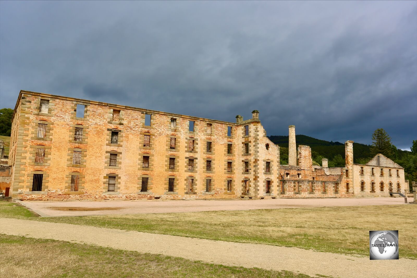
The Mausoleum of Ahmad Sanjar at Merv, a UNESCO World Heritage Site.
Turkmenistan is by far the most mysterious and unexplored of Central Asia’s ‘stans. A country rich in oil and gas, the government has no need for tourist dollars.
Turkmenistan became famous for the truly bizarre dictatorship of Saparmyrat Niyazov, who ruled as ‘Turkmenbashi’ (‘leader of the Turkmen’) until his death in 2006.
Learning the secrets of Turkmen carpets, from an expert guide, at the Turkmen Carpet Museum in Ashgabat.
During his presidency, Niyazov cultivated a cult of personality which would have even made the leaders of North Korea blush.
He installed grandiose monuments, and golden statues of himself, including one large, golden statue in Ashgabat which rotated to always face the sun.
Turkmen women, shopping for cloth at the Tolkuchka Bazaar in Ashgabat.
Niyazov turned Turkmenistan into a sort of totalitarian theme park, although since his death things have been tempered down.
Lying at a crossroads on the ancient Silk Road, Turkmenistan has a rich and complex history and is home to several UNESCO World Heritage sites.
An ancient seabed, the spectacular Yangykala Canyon is a highlight of Turkmenistan.
Mostly desert, Turkmenistan is sparsely populated but is home to many remote and spectacular sights such as the Yangykala Canyon and the Darvaza Gas Crater – known as the ‘Gates of Hell‘.
In the mountain village of Nokhur, grave markers include the horns of mountain goats, which are said to ward off evil spirits.
Despite its challenges, Turkmenistan remains a fascinating and unique country, with a rich cultural heritage and stunning natural beauty.
Location
Ashgabat, Turkmenistan
Situated at the heart of Central Asia, Turkmenistan is bordered by Iran to the south, Afghanistan to the southeast, Uzbekistan to the northeast, and Kazakhstan to the northwest.
It is also bounded by the Caspian Sea to the west, which provides access to international waters.
A map, on the office wall at Oguz Travel in Ashgabat, shows the location of Turkmenistan.
The country has a strategic location along the ancient Silk Road trade route, which has historically made it an important crossroads of cultures and civilizations.
The landscape of Turkmenistan is characterised by vast expanses of deserts and semi-deserts, punctuated by mountain ranges in the south and southeast regions.
The Karakum Desert, which covers much of the country, is one of the largest sand deserts in the world.
People
Two Turkmen boys, relaxing at the UNESCO World Heritage Site of Merv.
The people of Turkmenistan are diverse and have a rich cultural heritage that has been shaped by various influences over the centuries.
As of 2023, the country has a population of 6.3 million people, the majority of whom are ethnic Turkmen.
Demographically, the population is comprised of:
Turkmen 72%
Russian 12%
Uzbek 9%
Other 7%
Azeri 1%
The Turkmen people are known for their hospitality and traditional way of life. Many still practice the ancient nomadic lifestyle of their ancestors, living in yurts and moving from place to place with their herds of livestock.
Most Turkmen women wear traditional dress on a daily basis.
The culture of Turkmenistan is heavily influenced by Islam, which is the dominant religion in the country, with 93% of the population being Muslim.
Like other former-Soviet republics, where religion was banned for most of the 20th century, the version of Islam practiced in Turkmenistan is much less strict than the version of Islam found throughout the Middle East.
Despite the challenges faced by the country, the people of Turkmenistan remain proud of their identity and continue to work towards a better future for themselves and their country.
I found the Turkmen to be warm, friendly, welcoming, courteous and very curious about the foreigner in their midst. Most Turkmen have limited opportunities to meet a foreigner!
Turkmenistan’s President DJ
The Turkmen love to have fun and they also love their music – especially electronic dance music.
I found it strange that hotel pools, rather than offering a calm, relaxed environment, instead featured loud, mounted speakers, which boomed with the sound of electronic dance music.
Maybe this craze was started by the former President who was a keen DJ – as can be seen in the following video which shows him DJing at a New Year’s Eve party in 2020.
Flag
The five traditional carpet designs along the hoist side make the flag of Turkmenistan the most complex national flag design in the world.
The flag of Turkmenistan features a greenfield with a vertical stripe of five different carpet designs to the left of the flag.
The greenbackground represents Islam, which is the dominant religion in the country, and also represents the natural environment of the country, particularly its lush oases.
A giant Turkmenistan flag, flying over the city of Mary.
The five different carpet medallions represent the five main tribes of the Turkmen people, which are:
Teke
Yomut
Saryk
Choudur
Arsary
The designs are also meant to symbolise the country’s rich cultural heritage and history, as well as its status as a centre of traditional carpet weaving.
To the right of the carpets, there is a white crescent moon and five stars, which are also symbolic of the Islamic faith.
The crescent moon represents progress, while the five stars symbolize the five main pillars of Islam: faith, prayer, fasting, pilgrimage, and charity.
Currency
The manat is the official currency of Turkmenistan.
The Turkmenistanmanat is the official currency of Turkmenistan. If you have travelled to Azerbaijan, you will be familiar with this unit of currency as they use the Azerbaijan manat.
The original manat was introduced on 1 November 1993, replacing the rouble, which was the currency of the former Soviet Union.
The manat is subdivided into 100 tenge with both coins and banknotes in circulation. Banknotes are issued in denominations of 1, 5, 10, 20, 50, 100, and 500 manats.
The very colourful Turkmenistan manat banknotes.
The international currency code for the manat is TMT, although the currency is not exchangeable outside of Turkmenistan. It is important that you spend all of your currency before leaving the country.
There are many good souvenir and duty-free shops at Ashgabat International Airport, where you can make lastminute purchases to rid yourself of excess manat.
The manat is the official currency of Turkmenistan.
Due to the isolated nature of the country, there are few working international banking services in the country. It is best to take all the money, in the form of USD cash, you expect to spend with you into the country.
Since January 2015, the official exchange rate has been set at US$1 = 3.5 manats.
Black Market
As with most closed economies, a currency black market exists in Turkmenistan with many shopkeepers in Ashgabat keen to exchange USD or EUR, for manats, at very favourable rates.
During my stay, the official exchange rate was US$1 = 3.5 manats, while the unofficial rate was US$1 = 20 manats!
I exchanged money with one shopkeeper in Ashgabat who had pre-prepared bundles of 2,000 manat notes (worth USD$100). I handed him US$100, and he handed me one bundle of 2,000 manats.
During my 8 days in Turkmenistan, I exchanged a total of US$150, at the unofficial rate, to cover incidental costs. This was more than sufficient!
ATMs
ATMs do not exist in Turkmenistan!
Credit Cards
Credit cards cannot be used in Turkmenistan, which is strictly a cash society!
Costs
Since all visitors are required to join a fully escorted, fully inclusive tour, travel costs are as per the tour.
A one-week tour will typically cost between USD$500-700.
In addition to the cost of my tour, I had to pay for my roundtrip flight to Turkmenistan plus my visa and incidental expenses.
I flew from Dubai to Ashgabat with FlyDubai, who typically charge USD$730 for a return flight.
The cost of my tourist visa was US$99, which was payable in USD cash at Ashgabat International Airport.
In addition, I changed USD$150 on the black market to receive 3,000 manat. This was more than sufficient to cover incidental costs during my 8 days in Turkmenistan.
Tour Companies
Currently, the only way to secure a visa for Turkmenistan, either a tourist or transit visa, is to apply through a Turkmenistan-registered tour company.
I toured Turkmenistan, as a solo passenger, with Oguz Travel who I would highly recommend.
The modern office of Oguz Travel in Ashgabat.
All visitors to Turkmenistan need to join a fully escorted tour with a local tour company.
For a full description of the Visa process, please refer to the Visa Requirements section below.
A view of the office of Oguz Travel in Ashgabat.
Currently, Oguz Travel charge between Us$500 – $700 (per person) for a one-week tour of Turkmenistan. This cost excludes airfares and the visa fee.
The friendly staff at Oguz Travel in Ashgabat.
My tour included driver / guide, transport, meals, accommodation and a domestic flight. Everything was organised by the professional and friendly staff at Oguz Travel.
Sharing a traditional Turkmen lunch with Kemal, the Inbound Specialist at Oguz Travel, and his wife Aya, inside a Yurt, at a restaurant in Ashgabat.
I was fully escorted from the moment I arrived until I departed.
I recommend Oguz Travel for any trip to Turkmenistan.
Oguz Travel offered a reliable, professional service and ensured my trip to Turkmenistan was truly memorable!
A view of the white-marble apartment buildings which line the perfectly manicured avenues of Ashgabat, the capital of Turkmenistan.
Home to 730,000 souls, Ashgabat is the gleaming, spotlessly clean, perfectly manicured capital city of Turkmenistan.
The city is situated on the southern edge of the Karakum Desert, and its name translates to “City of Love” in the Turkmen language.
Video: Driving in Ashgabat, Turkmenistan.
From the moment you arrive at the huge white-marble Ashgabat International Airport, which is built in the shape of a falcon in flight, you can’t help but notice how perfectly clean and perfectly well maintained everything is.
Ashgabat is a showpiece capital city. Everything is built to razzle and dazzle.
While driving around the capital, you will see uniformed cleaners mopping and scrubbing the granite gutters and footpaths.
Home to only white cars, Ashgabat is a perfectly manicured, spotlessly clean capital city.
There is not a single piece of litter to be seen anywhere – the capital is kept spotlessly clean. I spoke to Turkmen, who had travelled abroad, and they commented on how surprised they were to find litter on the ground in other countries.
The streets of the capital are lined with thousands of cone-shaped pine trees, all of which are pruned by hand.
Turkmenistan’s mascot for the 2017 “Asian Indoor and Martial Arts Games” was an Alabay dog called “Wepaly”.
Beyond the line of pine trees, pristine, white-marble buildings line the perfectly maintained avenues and boulevards.
On the move in Ashgabat, the capital of Turkmenistan.
Ashgabat is known for its unique architecture, which features a mix of traditional Turkmen design and modern, futuristic styles.
Giant mosaic artwork adorns many apartment buildings in Ashgabat.
Many of the buildings in the city are made from white marble, giving it a distinctive look.
It’s interesting to note that while white-marble is used on buildings, and monuments, throughout the country, it’s all imported! Turkmenistan does not possess any sources of marble.
Quirky Ashgabat
There are many quirky, but seriously strict rules, which govern life in Ashgabat.
As you cruise around the streets of Ashgabat, you can’t help but notice that everyone seems to be driving a very clean, late model, white car.
Drivers in Ashgabat can drive any colour car they wish – provided it’s white!
This is a government regulation which was introduced by the previous president, Gurbanguly Berdymukhammedov, who believed that the colour white was ‘lucky’. It is for this reason that all buildings are clad in white marble!
A few exceptions have been made that allow some people to drive silver cars!
As for the cleanliness of all vehicles, if a driver is found to be driving a dusty or dirty car in Ashgabat, he can be stopped by one of the many roadside policemen (they are stationed on every street corner in Ashgabat) and the driver will be issued a fine!
After one long day-trip into the countryside, my driver/ guide dropped me at my hotel in Ashgabat at 10 pm. While I was ready for bed, he mentioned that he first needed to go and get his car washed before he went home to sleep.
When I enquired as to why it was so urgent to get his car washed so late at night, he explained that if he is stopped by a policeman he could be fined because of his dirty car.
All cars in Ashgabat are kept spotlessly clean!
Another rule, which is hugely inconvenient for any Turkmen visiting the capital from the countryside, is that only cars bearing a license plate issued in Ashgabat (AG) or the surrounding Ahal (AH) region are allowed to enter the capital.
Drivers, who are driving cars with license plates issued in other regions, must park their cars on the outskirts of the capital, in specially built mega-sized garages, and either take a taxi, public transport or meet a family member who is driving a car (white of course!) with a local license plate.
One of the most popular forms of inter-city public transport in Turkmenistan are shared taxis. Almost all taxis bear regional license plates which means they are unable to drive into the city to drop their passengers. Instead, they must park on the outskirts of Ashgabat, where everyone must then transfer to other vehicles to complete their journey.
If regional drivers do attempt to drive into the capital, they will be stopped and fined by one of the many policemen!
Car license plates in Turkmenistan are suffixed with a two-letter region code, such as this one, which is from the Balkan (BN) region.
Car license plates in Turkmenistan are suffixed with a two-letter region code as follows:
AG – Ashgabat
AH – Ahal
BN – Balkan
DZ – Daşoguz
LB – Lebap
MR – Mary
The upside for those living in other regions is that they can drive any colour car they wish and they don’t have to wash their cars if they become dirty. Life for those who live in the regions is a little more relaxed.
Sights of Ashgabat
Turkmen Carpet Museum
A highlight of the Turkmen Carpet Museum is the Guinness Book of Records-listed “largest carpet in the world” (left wall) which is 301 square metres in area and weighs 1.2 tons.
The Turkmen Carpet Museum in Ashgabat is a renowned institution dedicated to the art and history of Turkmen carpets. It is a veritable house of treasures!
A highlight of Ashgabat was my guided tour of the Turkmen Carpet Museum.
The museum houses an impressive collection of Turkmen carpets and rugs, including the largest handwoven carpet in the world, which is 301 square metres in area and weighs 1.2 tons.
Displays at the Turkmen Carpet Museum in Ashgabat.
Turkmenistan is famous for its handwoven carpets, which are often considered some of the finest in the world. These carpets are known for their vibrant colors, intricate geometric patterns, and rich cultural symbolism.
Each of the five different tribes in Turkmenistan had their own unique carpet design. It’s these five unique designs which now feature on the national flag.
More than just a display of pretty carpets, the museum provides visitors with historical context about the art of carpet-making in Turkmenistan.
You can learn about the significance of carpets in Turkmen culture, their role in daily life, and the traditional techniques used in their creation.
The museum has multiple exhibition halls displaying various types and styles of Turkmen carpets.
Each hall focuses on specific regions, historical periods, or weaving techniques, allowing you to explore the diversity of Turkmen carpet art.
3D carpets, which feature raised medallions, at the Turkmen Carpet Museum in Ashgabat.
They even have 3D carpets – although you don’t need to wear special glasses to view them!
A fascinating, double-sided carpet, at the Turkmen Carpet Museum.
One of my favourites were the double-sided carpets. Truly unique!
All visitors are led through the museum by an expert guide who describes the various wonders which are displayed.
My guide at the Turkmen Carpet Museum, explained the finest of the details which are hidden inside each carpet.
There is also a museum shop which sells carpets and other trinkets. These carpets make for unique and culturally rich mementos of your visit.
Traditional Turkmen caps, known as telpek, for sale at the Turkmen Carpet Museum giftshop.
Located in the building next door to the museum is the Ministry of Carpets. If you wish to export a carpet which is greater than one square metre in size, you will need to apply for an export permit from the ministry.
One day, I’ll return to Ashgabat to go carpet shopping!
Turkmenbashi Ruhy Mosque
The largest mosque in Central Asia, Turkmenbashi Ruhy Mosque is considered the main mosque of Turkmenistan.
The Turkmenbashi Ruhy Mosque, also known as the Gypjak Mosque, is considered the main mosque of Turkmenistan. It is the largest mosque in Central Asia.
A view of the Turkmenbashi Ruhy Mosque in Ashgabat.
This grand mosque, which was built by the French construction company Bouygues (who also built the fabulously opulent Yyldyz Hotel) is located 7 km (4.3 mi) west of Ashgabat, in the town of Gypjak, which was the home town of President Saparmyrat Nyýazow.
A view of the large, star-shaped, handwoven Turkmen carpet, which lies beneath the central dome, at the Turkmenbashi Ruhy Mosque.
Every inch of this mosque is absolutely breathtaking, with only the finest of materials used for its construction.
The outside is completely made of white-marble, with a massive gold-covered dome, which is 50 metres in diameter, and gold-accented minarets which soar to 91 metres.
A view of the breathtakingly beautiful Turkmenbashi Ruhy Mosque in Ashgabat.
The height of the minarets corresponds to “1991”, the year Turkmenistan became independent.
A view of the dome of the Turkmenbashi Ruhy Mosque.
Inside, lush, handwoven, Turkmen carpets cover the floor, while golden chandeliers illuminate the defining feature of the mosque: the central dome, which is intricately tiled with gold and blue mosaic tiles.
A view of the mausoleum of former president, Saparmyrat Nyýazow.
The mosque opened on 22 October 2004, and was built by Nyýazow, along with a mausoleum in preparation for his death.
A view of the dome, inside the mausoleum of former president, Saparmyrat Nyýazow.
Nyýazow died two years later, and was buried in the mausoleum on 24 December 2006, along with other family members.
Detail view of the main entrance door of the Turkmenbashi Ruhy Mosque.
The mosque has been at the centre of controversy as scriptures from both the Quran and the Ruhnama (The Book of the Soul), Nyýazow’s ‘pseudo-spiritual guide to life’ are inscribed into the walls.
A view of the Turkmenbashi Ruhy Mosque which features four minarets.
Also controversially, the gold lettering on the minarets reads: “The Ruhnama is a holy book, the Koran is Allah’s book.”
A view of the mihrab at the Turkmenbashi Ruhy Mosque.
It has outraged many Muslims that the Ruhnama is placed as the Quran’s equal.
A door at the Turkmenbashi Ruhy Mosque.
Despite its capacity to accommodate 10,000 worshippers’, the mosque is often empty as the Ruhnama inscriptions are considered blasphemous by devout Muslims.
A view of the Turkmenbashi Ruhy Mosque in Ashgabat.
Another possible reason the mosque is normally empty is that nobody really liked Turkmenbashi, Turkmenistan’s first president-dictator, who built the mosque in his mother’s honour and is now buried alongside her in the mausoleum.
The Turkmenbashi Ruhy Mosque – spectacular and opulent construction, but one which has caused much controversy.
Monument Arch of Neutrality
The Monument Arch of Neutrality in Ashgabat.
The 75 metre (246 ft) tall, Monument Arch of Neutrality, was built to commemorate Turkmenistan’s status of permanent neutrality, which was recognised by the United Nations in 1995. Neutrality was a key foreign policy principle of Turkmenistan.
The arch was built in 1998, at a cost of US$12 million, on the orders of then president, Saparmyrat Nyýazow, to commemorate the country’s official position of neutrality.
A golden statue of former president, Niyazov, rotates to follow the sun.
As was fitting with his cult of personality, he also ordered that the monument be topped by a 12-metre (39 ft) tall gold-plated statue of himself, which always rotated to face the sun.
While the arch features an elevator which ascends to an observatory, this was not working at the time of my visit.
Turkmenistan Independence Monument
The Turkmenistan Independence Monument commemorates the country’s independence in 1991.
The Turkmenistan Independence Monument was constructed to commemorate Turkmenistan’s declaration of independence from the Soviet Union, which occurred on October 27, 1991.
At its core, the monument features a tall central column, made of white marble (of course!). This column is adorned with intricate Turkmen motifs and decorative elements.
Ruhnama Monument
The truly bizarre Ruhnama Monument in Ashgabat.
Located down the hill from the Turkmenistan Independence Monument is the truly bizarre Ruhnama Monument.
The former president of Turkmenistan, Saparmurat Niyazov, wasn’t simply happy enough with his cult of personality, he also wanted to guide the nation by authoring a spiritual guide.
The Ruhnama, which translates as “The Book of the Soul”, was a spiritual guide provided to the Turkmen people by the president.
The book was introduced to Turkmen culture in a gradual but eventually pervasive way. Niyazov first placed copies in the nation’s schools and libraries but eventually went as far as to make an exam on its teachings an element of the driving test.
It was mandatory to read Ruhnama in schools, universities and governmental organisations. New governmental employees were tested on the book at job interviews.
After the death of Niyazov in December 2006, the books popularity remained high, however in recent years, its popularity has waned.
Alem Entertainment Centre
A view of the Alem Entertainment Centre, whose main attraction is the world’s largest indoor Ferris wheel.
In 2012, Turkmenistan gained another entry in the Guinness Book of World Records, with the “largest Ferris wheel in an enclosed architectural design“.
Located in Ashgabat, the world’s largest indoor Ferris wheel is 47 metres high and has a diameter of 57 metres.
The main attraction at the Alem Centre, the Ferris wheel is 47 metres high and has a diameter of 57 metres. A large glass and white-steel casing houses the Ferris wheel, which has 24 six-seat cabins.
The Alem Entertainment Centre, also features a bowling alley, cinema screens, a restaurant, and a planetarium.
Tolkuchka-Basar
Turkmen women shopping for textiles at the Tolkuchka Bazaar in Ashgabat.
Tolkuchka-Basar, also known as Tolkuchka Bazaar, is one of the largest and most famous open-air markets in Central Asia.
Handmade souvenirs for sale at the carpet market at Tolkuchka Bazaar.
Located on the outskirts of Ashgabat, this bustling bazaar is known for its wide variety of goods, including traditional crafts, textiles, electronics, carpets and much more.
As a sign of marital status, married Turkmen women typically wear a head scarf, while single girls do not!
Turkmen clothing is known for its vibrant and colourful designs.
Colourful decorations on sale at the at the Tolkuchka Bazaar in Ashgabat.
he use of bright colors, intricate patterns, and embroidery is a significant characteristic of their traditional attire.
A shopkeeper at the Tolkuchka Bazaar in Ashgabat.
During my visit to the bazaar with Kemal, I visited the textile market where I could observe local women purchasing lengths of cloth for making traditional Turkmen clothing.
Shopping for cloth at the at the Tolkuchka Bazaar in Ashgabat.
While western-style clothing is popular among the youth of Turkmenistan and those living in urban areas, traditional clothing is still largely worn, especially by women.
Many Turkmen women prefer to make their own traditional clothing.
Traditional attire remains an important symbol of Turkmen identity and cultural heritage.
A view of a small selection of the Turkmen carpets, available for purchase, at the carpet bazaar in Ashgabat.
We also visited the carpet bazaar where I was offered the most amazing Turkmen carpets at the craziest of prices!
This kind lady offered to sell me this small Turkmen carpet for just US$10.
The low prices offered had me salivating and I was keen to buy, however, any carpet larger than one square metre requires an export permit from the Ministry of Carpet! Yes – there is a ministry for carpets!
My guide, Kemal, provides a sense of scale to the bargain of the century. I was offered this handwoven Turkmen carpet for just US$50!! Incredible!
The prices for handwoven Turkmen carpets at the Tolkuchka Bazaar were a steal! The prices were shockingly cheap, especially for something that would have taken so long to make!
A “Lenin” carpet for sale at the at the Tolkuchka Bazaar.
However, as a full-time traveller, without a place to currently call home, it made no sense for me to buy. I did promise Kemal that I will return one day, when I am ready to buy a horde of bargain Turkmen carpets.
An amazing felt carpet for sale at the Tolkuchka Bazaar. I love felt carpets!
Despite the fact that I am a full-time traveller, without a base, I do have a small carpet collection which is comprised of pieces I have purchased during my travels.
One day, I will have a home where I can display my collection. Then I’ll return to Ashgabat to add some Turkmen carpets to my collection.
Alabay Monument
The Alabay dog is the national dog of Turkmenistan.
Unveiled in 2020 by the then President, Gurbanguly Berdymukhamedov, this 6m (19ft) golden statue of the Alabay dog, the national dog of Turkmenistan, adorns a roundabout in downtown Ashgabat.
The Alabay is a home-bred Turkmen variety of the Central Asian shepherd dog and is listed under the country’s national heritage.
Akhal-Tekes Horse Stable
The Akhal-Teke, a breed of horse which originated in the Karakum Desert, is integral to Turkmen culture.
The horse, and specifically, the Akhal-Tekes breed of horse, is an integral part of Turkmen culture.
Horses in Turkmenistan are treated like royalty, living in plush stable complexes, where they are groomed, bathed, fed the finest of food and generally pampered.
A young stable-hand, with one of the prize horses from the stable.
Among all equine breeds known today in the world, the Akhal-Teke, which originated in the Karakum Desert, is universally considered one of the most ancient ones.
On the outskirts of Ashgabat, large stable complexes house these magnificent beasts. Visitors are able to visit to see these horses up close.
The stable-hand, taking a horse for a gallop.
Although I am not a horse person, I could appreciate that these horses truly are special. They are the most beautiful of horses!
Kow Ata Underground Lake
Kow Ata is an underground lake, which is located inside a large cave, 90 km west of Ashgabat.
Located 90 km west of Ashgabat, Kow Ata is an underground lake, which is located inside a large cave, near the village of Bäherden, at the foot of the Kopet Dag mountain.
The cave was reportedly discovered in the 19th century by railway workers during construction of the Ashgabat to Turkmenbashi railway.
Located 55-metres below the surface, Kow Ata underground lake is reached via a series of stairways.
The lake is located 55-metres (180 ft) below the entrance of the cave, and is reached by a series of stairways. No sunlight reaches inside the cave and lighting on the stairway is poor. I had to use the torch on my phone to light the way.
The length of the lake, which lies in darkness, is reported to be between 75 metres (246 ft) and 80 metres (260 ft). The average depth is about 10 metres (33 ft), with a maximum depth of 15 metres (49 ft).
It’s a popular swimming place for locals escaping from the scorching summer heat outside.
A view of the long stairway, which descends 55-metres through the cave, to Kow Ata underground lake.
Entrance to the cave costs 50 manat!
Several restaurants in the car park provide food and drinks.
Nokhur
Located in the mountains of southern Turkmenistan, Nokhur village is known for its unique culture, traditional way of life, and stunning natural surroundings.
Nokhur is a village in the Akhal velayat of Turkmenistan, located at the western end of the Kopet dag ridge, in the mountains, at an altitude of 1,000-1,100 metres above sea level.
A highlight of Nokhur village is its cemetery full of goat-horn grave markers.
The area is known for its unique culture, traditional way of life, and stunning natural surroundings. The village is nestled in the Kopet Dag mountains, providing it with a breathtaking backdrop of rugged landscapes.
A view of the cemetery at Nokhur, a highlight of the village.
The village is inhabited by the Nokhuris people who are different from other Turkmens. They have their own language and distinct cultural practices.
A truck, fully laden with hay, in Nokhur village, Turkmenistan.
It is said that the residents of Nokhuris are descendants of soldiers who first arrived in the region, as part of the army of Alexander the Great, and who decided to stay and settle in the scenic valley, rather than to continue moving and fighting, as the army made its way south towards Persia.
While in Nokhur village, I had lunch with my driver, underneath the waterfall, at the excellent Soygi Dagy restaurant.
At the entrance to the village, the excellent Soygi Dagy restaurant, serves very tasty Turkmen cuisine at the base of a crashing waterfall. A fantastic location for a restaurant as the waterfall acts as a natural air-conditioner on hot days.
Nokhur Cemetery
Graves at Nokhur cemetery include the horns of mountain goats, which are believed to keep evil spirits away.
The cemetery of Nokhur is the main sight in this mountain village. Its graves, marked by the horns of mountain goats, point to burial rites steeped in animism, sprinkled with Zoroastrianism.
Gravestones at Nokhur cemetery.
The goat horns are there to fight off evil spirits, while the gravestones are marked with grooved steps, to help the deceased ascend to heaven.
A wooden grave marker at Nokhur cemetery, clearly showing the goat horns and the grooved steps.
The reverence of mountain goats clearly predates Islamic traditions, and though today the Nokhuris are devout Muslims, this part of their ancient belief system has continued to survive.
Although the residents of Nokhur are now Muslim, they still incorporate pre-Islamic animist and Zoroastrian believes in their culture.
Nokhur Plane Tree
Tea vendors, selling tea, under the shade of the giant Plane tree in Nokhur village.
Located in the centre of Nokhur village is a huge, centuries-old, plane tree. A hollow in the trunk can accommodate several people at once.
A tea seller, selling his herbal teas, under the shade of the giant plane tree in Nokhur village.
Visitors can purchase herbal teas, which are sold by a couple of vendors who make tea from drying locally collected wildflowers and herbs.
The herbal teas sold at Nokhur village are made from locally dried herbs and wildflowers.
Balkanabat
A view of the “Monument to the Desert Explorers” in Balkanabat.
Balkanabat is the capital city of the Balkan Province in Turkmenistan. A sleepy town, Balkanabat is located in the western part of Turkmenistan, 150 km inland from the coast of the Caspian Sea and the port city of Turkmenbashi.
This regional hub is situated in the heart of the Karakum Desert and serves as a gateway to various natural resources and energy reserves in the region.
The city’s economy is closely tied to the oil and gas industry, as the region around Balkanabat is rich in hydrocarbon resources.
Oil and gas exploration, production, and refining are significant economic activities in and around the city.
The Monument to the Desert Explorers
The “Monument to the Desert Explorers” is dedicated to the pioneers of the oil industry in Turkmenistan.
The only real sight in Balkanabat is this monument which is located on the western edge of town.
The Monument to the Desert Explorers is sculpted from concrete, but made to look like sandstone.
It commemorates the Turkmen and Russian explorers who discovered oil in the region, which ultimately led to the birth of Balkanabat.
The sculpture depicts several explorers huddling around a camel, who is carrying barrels of oil, taking shelter from an apparent sandstorm as they make their way across the desert.
Yangykala Canyon
A highlight of Turkmenistan, the stunningly beautiful Yangykala Canyon.
A truly stunning sight, the Yangykala Canyon is a stunning natural geological formation located about 2 hours inland from either Balkanabat or Turkmenbashi, via some terribly potholed roads, which eventually turn to gravel.
Vibrant, colourful, rock formations at Yangykala Canyon are the result of iron minerals in the soil.
Often referred to as the “Grand Canyon of Turkmenistan” due to its unique and striking landscapes, Yangykala was once underwater, the floor of an ancient ocean, the gigantic Tethys Sea, that existed millions of years ago.
Once the Tethys Sea had dried, it left behind a rocky landscape that was slowly eroded by wind and rain, cutting out cliffs and canyons whose colourful walls are now on full display – an artwork by Mother Nature!
Fossilised seashells can be found everywhere at Yangykala Canyon.
Evidence of the former seabed can be found everywhere at Yangykala Canyon, in the form of fossilised seashells.
Remnants of the Tethys Sea remain today as the Mediterranean, Black, Caspian, and Aral seas.
My driver Rejep, enjoying the panoramic view at Yangykala Canyon.
One of the most captivating features of the Yangykala Canyon is the array of vibrant colors that adorn the rock formations, a result of high iron mineral content.
Views of Yangykala Canyon.
The layers of sedimentary rock display shades of red, orange, yellow, and white, creating a mesmerising, and at times surreal, visual spectacle.
There are several viewpoints along the rim of the canyon that offer breathtaking panoramic views of the surrounding landscapes. These can be access with a high-clearance 4WD.
Visitors can stand at these vantage points and marvel at the expanse of the canyon, the intricate patterns of the rock layers, and the play of light and shadows.
Views of the stunningly beautiful Yangykala Canyon.
The canyon is located in a relatively remote and arid region, which adds to its mystique. Its isolation has helped preserve its pristine landscapes and minimise human impact.
Well off the beaten track, the only way to reach the canyon is with a private vehicle.
The spectacularly colourful Yangykala Canyon, a highlight of Turkmenistan.
There are absolutely no facilities anyone near the canyon, so you need to come prepared with all the water and food you might need. On the day I visited, temperatures in the canyon were in the mid-40’s Celsius!
Turkmenbashi
White-marble hotels, line the Caspian Sea in the Avaza National Tourist Zone at Turkmenbashi.
Turkmenbashi, formerly known as Krasnovodsk, is a port city and one of the major urban centres in Turkmenistan.
The city’s name was changed from Krasnovodsk to Turkmenbashi in honor of Turkmenbashi (Saparmurat Niyazov), the first President of Turkmenistan, in 1993. The name “Turkmenbashi” translates to “Leader of the Turkmen.”
It holds significant economic and strategic importance due to its access to the Caspian Sea and its role in trade and transportation.
Turkmenbashi is located on the northeastern coast of the Caspian Sea, in the Balkan Province of Turkmenistan. It serves as the administrative centre of the Balkan Province.
One of the most crucial aspects of Turkmenbashi is its port, which is the largest port on the Caspian Sea.
The city’s economy is closely tied to maritime activities, shipping, and trade. A regular passenger ferry connects Turkmenbashi to Baku, the capital of Azerbaijan.
The port plays a pivotal role in the export and import of goods, particularly energy resources like oil and gas.
Similar to other parts of Turkmenistan, Turkmenbashi has a significant presence in the oil and gas sector. The region is rich in hydrocarbon resources, and the city is involved in oil and gas exploration, production, and transportation.
Avaza National Tourist Zone
A view of the swimming pools at the Hazar Hotel, the most popular hotel in the Avaza National Tourist Zone.
Close to Turkmenbashi is the Avaza National Tourist Zone, a beach resort area along the Caspian Sea which was inspired by the developments of Dubai, but which lacks the crowds or the buzz of the glitzy Emirate.
Avaza was developed to attract tourists and features modern hotels, entertainment facilities, and recreational opportunities. However, the tourists have yet to arrive! Avaza is probably the least known resort in the world!
At the time of my visit, there were a handful of Turkmen holiday-makers enjoying the facilities, but it was very quiet – dead really!
This tourist zone is a peculiar place!
A view of the white-marble hotels which line the shore of the Caspian Sea, inside the Avaza National Tourist Zone.
Lining the beach are a number of white-marble (of course!) high rise hotels, each one built, and operated, by a different government department.
Beyond the hotels, expansive, manicured, perfectly clean, parks and pine forests allow holiday makers to walk and exercise in a pollution-free environment.
When Avaza was created, the president of Turkmenistan deemed that the zone should be kept car-free zone, so that those on holiday are not subject to pollution, traffic or noise.
As a result, all vehicles are to be parked in a giant parking station at the entrance to the zone, requiring passengers to transfer to a special fleet of taxis, who operate shuttle services to the different hotels.
During my visit to Avaza, I spent time relaxing with my driver/ guide – Rejep – by the large swimming pool at the Hazar Hotel, which is owned by the Central Bank of Turkmenistan.
Apparently, the Hazar Hotel has the best swimming pool of all the hotels. The pool is popular with visiting locals, and features the obligatory boom-box speakers, booming out loud electronic music.
Mary
Located in the southeast of Turkmenistan, 366 km east of Ashgabat via a rough, deteriorated, Soviet-era highway, the city of Mary (pop: 210,000) is the capital of the province of the same name.
It is located near the border with Afghanistan and has historically been an important trade and cultural centre due to its strategic location along the Silk Road.
Mary is the launching pad for visits to the nearby UNESCO World Heritage Site of Merv, which lies 33 km outside the city.
Merv
A highlight of Merv, the 12th-century Mausoleum of Ahmad Sanjar, is considered one of the finest examples of Seljuk architecture.
Merv is a UNESCO World Heritage Site located 33 km from the city of Mary. It is one of the most important archaeological sites in the region, and is considered one of the greatest cities of the Islamic world.
A view of the ornate ceiling of the Mausoleum of Ahmad Sanjar at Merv, Turkmenistan.
At its peak, Merv was a major centre of trade and culture, and was an important stop along the Silk Road.
Merv was inhabited from the 3rd millennium BCE to the 18th century CE, and was ruled by a series of empires, including the Achaemenids, the Parthians, the Sassanids, the Arabs, the Seljuks, and the Mongols.
Camels grazing around an ancient structure at historic Merv.
The city was known for its impressive architecture, including its mosques, palaces, and fortifications, many of which have been partially or fully restored.
Merv is a fascinating destination for those interested in history and archaeology, offering a glimpse into the rich cultural heritage of Central Asia.
Mausoleum of Ahmad Sanjar
The Mausoleum of Ahmad Sanjar at Merv.
One of the highlights of Merv is the impressive Mausoleum of Ahmad Sanjar, a 12th-century mausoleum that is considered one of the finest examples of Seljuk architecture.
The fabulous dome of the Mausoleum of Ahmad Sanjar was heavily damaged during the Mongol sacking of Merv in 1221 CE.
Built in 1157 CE, the mausoleum commemorates Ahmad Sanjar, a Seljuk ruler of Khorasan. Throughout his reign, Sanjar fought off several invasions and uprisings, until finally being defeated by the Oghuz.
Seljuk architecture at its best – the interior of the Mausoleum of Ahmad Sanjar at Merv.
During the Mongol sack of Merv in 1221 CE, the mausoleum was burnt, only after the Mongols had dug up the grave of Ahmad Sanjar, looking for precious objects.
A view of the tomb, and the mausoleum, of Ahmad Sanjar at Merv.
The fire caused significant damage to the mausoleum, destroying much of the building’s exterior brickwork and causing the outer dome to collapse.
Merv remained severely depopulated in the period following the Mongol invasion and the tomb deteriorated further due to centuries of neglect.
Great Kyz Kala
One of the most iconic structures at Merv, the Great Kyz Kala is a monumental mudbrick, fortified residence.
The Great Kyz Kala is a monumental mudbrick, fortified-building, one of a number of similar structures known as köshks, within the UNESCO World Heritage Site of Merv.
This iconic structure is thought to have been built somewhere between the 6th and 8th century CE, in the late Sassanian or early Islamic period, and to have continued in use until the Mongol sack of Merv in 1221 CE.
A view of the Great Kyz Kala at Merv, Turkmenistan.
Located just outside the city walls, it seems likely to have functioned as a fortified residence
Darvaza
Possibly the #1 tourist attraction in Turkmenistan – the Darvaza Gas Crater.
Darvaza, also known as the Door to Hell, is a natural gas field located in the Karakum Desert of Turkmenistan. It is famous for its large, burning crater, which has been burning continuously since 1971.
The crater is very popular with tourists, who flock to see its eerie glow in the darkness of night.
The Darvaza gas crater was created when Soviet geologists were drilling for gas in 1971 and the ground collapsed, creating a large hole.
The gas that was released from the hole was thought to be harmful to local residents, so the decision was made to set the gas on fire to prevent it from spreading.
A view into the Gates to Hell – the Darvaza Gas Crater lies in a remote corner of the Karakum desert.
The hope was that the fire would burn out within a few weeks, but it has been burning continuously ever since.
Today, the Darvaza crater is a popular tourist attraction.
Taking photos around the rim of the Darvaza Gas Crater is like trying to photograph inside an oven.
The crater is about 60 metres wide and 20 metres deep, and the flames can reach up to 10-15 metres high.
While the area around the crater is remote and can be difficult to access, many tour operators offer guided trips to Darvaza for those interested in seeing the fiery spectacle up close.
The gas inside the Darvaza Gas Crater was ignited when it was first discovered in the early 1970’s and has been burning ever since.
Getting up close to take photos is like standing close to a large flame grill! Thermal winds, which are whipped up by the flames, can easily singe the hairs on your head!
On the day of my visit, the temperate in the desert was around 45 degrees Celsius, while the temperate at the rim of the crater was around 70 degrees Celsius. My camera almost melted!
Accommodation at Darvaza
An onsite Yurt village provides accommodation options for those who wish to overnight at the Darvaza Gas Crater.
For those who wish to stay overnight, an onsite yurt village provides accommodation options.
A view inside one of the accommodation Yurts at Darvaza.
Restaurant at Darvaza
A view of the restaurant complex at the Darvaza Gas Crater.
The nearest dining options in this part of the desert are hundreds of miles away in Ashgabat. One onsite restaurant provides basic meals for those staying overnight.
The restaurant at the Darvaza Gas Crater provides a place to seek shade from the intense desert heat.
Accommodation
My accommodation in Ashgabat – the recently opened, very opulent, 5-star, Yyldyz Hotel.
Accommodation options catering for all budgets can be found in each of the major cities, including Ashgabat, Turkmenbashi and Mary.
Accommodation will be arranged by your tour company as per your requirements.
During my time in Turkmenistan, I experienced two different types of accommodation, which were at complete opposite ends of the accommodation spectrum.
What looks like an artist’s concept drawing for a development project is actually the view from my room at the Yyldyz Hotel, Ashgabat.
I stayed for all but one of my nights at the recently opened, 5-star, Yyldyz Hotel in Ashgabat, which is regarded as the best hotel in Turkmenistan and is beyond luxurious!
I also got to experience a family homestay when my driver/ guide invited me to stay with him and his family in their 5-bedroom apartment in the western city of Balkanabat.
While a family home cannot be compared to the opulent offerings of a 5-star hotel, my homestay experience was one I will forever treasure! Something truly special!
Ashgabat
A room fit for a king! Or even a solo traveller! My palatial room at the Yyldyz Hotel, Ashgabat.
The Yyldyz Hotel is a 5-star luxury hotel located on a hill on the outskirts of Ashgabat. It was built by the French construction company Bouygues Bâtiment International.
The tear-shaped design of the Yyldyz Hotel reminded me of the Burg Al-Arab Hotel in Dubai.
The imposing, teardrop-shaped tower, which reminded me of the Burj Al Arab Hotel in Dubai, is more than 100 metres tall, and contains 155 spacious and opulent rooms/ suites, which are fit for royalty.
The lofty and plush, marbled-lined lobby, at the Yyldyz Hotel in Ashgabat.
From the moment you step into the lofty, marble-clad lobby, you know you have arrived somewhere special. The English-speaking reception staff are professional and provide a good level of service.
Video: Approaching the Yyldyz Hotel in Ashgabat, Turkmenistan.
My room/ suite was incredibly spacious, much larger than your average apartment.
A view of one half of my bathroom at the Yyldyz Hotel in Ashgabat, Turkmenistan.
As I entered, a hallway led first to a huge bathroom, which featured a large shower, bathtub, and underfloor heating.
Enough room for a single traveller! The other half of my bathroom at the Yyldyz Hotel.
The bathroom was almost as large as some hotel rooms I’ve stayed in.
My suite at the Yyldyz Hotel was furnished with a sofa and decorated with paintings of Turkmen horses.
The hallway then led to a sitting room where there was an office desk and chair, coffee machine, refrigerator etc.
Beyond the sitting room, the incredibly large bedroom featured ceiling to floor windows along the entire front wall, which provided the most stunning views of Ashgabat. Even the king-sized bed seemed to be too small for this huge space.
Plenty of room to relax, in my bedroom at the Yyldyz Hotel in Ashgabat.
All of the walls of my room were adorned with original artworks featuring Turkmen horses.
Each morning, a generous buffet breakfast was served in the hotel restaurant.
The very large indoor pool at the Yyldyz Hotel in Ashgabat.
Facilities at the hotel include an indoor and outdoor pool (both are huge and very popular with visiting locals), a gym, a sauna/ spa, a banqueting hall, a panoramic restaurant, nightclub and pub.
The outdoor pool at the Yyldyz Hotel in Ashgabat is very popular with visiting locals.
The Yyldyz Hotel was a special experience and, since I travelled to Turkmenistan with Oguz Tours, they were able to offer this deluxe experience at a special promotional rate.
Balkanabat
My driver/ guide, Rejep, and his family, inside their apartment in the city of Balkanabat.
During my first few days in Turkmenistan, I travelled with an amazing driver/ guide by the name of Rejep.
Rejep, with his son, who was celebrating his 1st birthday during my visit.
One evening, we arrived in his hometown of Balkanabat, which is located in the west of Turkmenistan, 153 km inland from the Caspian Sea port city of Turkmenbashi.
Dinner is served! A view of the living room at Rejep’s apartment. I ate and slept on the floor in this room.
Rejep had invited me to experience a traditional homestay, by staying with his extended family who live in a 5-bedroom apartment which dates from the Soviet era.
Rejep and I shared a traditional Turkmen meal which was prepared by his very talented wife. Truly delicious!
Away from all the glitzy, showpiece, marble-clad buildings of Ashgabat, and a million miles from the opulence of the Yyldyz Hotel, most Turkmen live in old Soviet apartment blocks which remain totally unrenovated.
A traditional Turkmen dinner of Plov, salad and vegetables which was prepared by Rejep’s wife.
These apartments are purely utilitarian – solid, but cold, constructions, which are not noted for any form of luxury or comfort. They are the mainstay of private residential housing in Turkmenistan.
Satellite dishes galore! A view of the Soviet-era apartment building in Balkanabat, where my driver/ guide Rejep lives with his extended family.
What was interesting to note were all the satellite dishes which clung to the outside walls of all apartment buildings in Turkmenistan.
The Turkmen prefer to tune into Turkish TV channels, which offer game shows, reality shows and other programs, which are much more entertaining than the stale offerings of Turkmenistan state television.
My bed for the night, on the floor of the living room at Rejep’s apartment.
During my stay at his home, Rejep’s son was celebrating his 1st birthday. He was certainly curious about the stranger in his house.
Rejep’s wife prepared the most delicious meals, including Plov, which was full of flavour.
Rejep and I shared a traditional breakfast on the floor of his living room.
What’s notable about Turkmen homes is that they are sparsely furnished. Everything, from sleeping, eating and preparing meals, is done on the floor.
Eating Out
The cuisine of Turkmenistan, reflects its nomadic heritage, as well as influences from neighbouring countries like Iran, Afghanistan, and Russia.
The cuisine is characterised by its use of simple, locally available ingredients, and a focus on hearty and flavourful dishes.
Meat holds a central place in Turkmen cuisine, especially mutton, beef, and occasionally camel meat. Lamb is particularly popular and is often used in various dishes, including stews, kebabs, and pilafs.
Pilaf (Plov) is a staple dish in Turkmen cuisine. It typically consists of rice cooked with meat (usually lamb or beef), vegetables, and aromatic spices. The dish is often garnished with fried onions, raisins, and sometimes saffron, giving it a rich and flavourful profile.
Grilled skewered meats, known as kebabs, are widely enjoyed in Turkmenistan. These can include various types of meat, such as lamb, beef, and chicken, often marinated with spices and herbs before grilling.
Bread, known as “çörek” in Turkmen, is a staple food. The traditional bread is round and flat, often baked in tandoor ovens. It is usually served with various dishes and used to scoop up food.
Dairy products like yogurt, Ayran (a yogurt-based drink), and various types of cheeses play a role in Turkmen cuisine. These items are not only consumed as they are but are also used as ingredients in different dishes.
For those who love to eat melons, Turkmenistan is melon-central and the Turkmen are fanatical about their melons.
On our drive to his family home, my driver, Rejep, stopped at several roadside melon stalls to purchase a variety of melons. At each stall, he spent time to feel and smell each melon, being careful to select only the best!
By the time we had reached his home, he had purchased seven different melons – all of which tasted amazing!
Restaurants /Cafés
While in Turkmenistan, all meals were arranged by my tour company, Oguz Travel.
Although tea is an essential part of Turkmen culture, coffee is becoming more popular, with cafés offering caffeine addicts a choice of espresso, cappuccino, café latte etc.
Ashgabat
Welcome to coffee heaven! Bazetti Coffee in Ashgabat!
The best coffee in Ashgabat is served at Bazetti Coffee which is hidden away on the ground floor of a non-descript, white-marble, building in a suburb of Ashgabat.
An amazing cappuccino at Bazetti Coffee in Ashgabat.
There are no signs to be seen anywhere! You just have to know where to go! I always went with my guide, Kemal, who knew the way and who is also a fellow caffeine addict.
Bazetti Coffee in Ashgabat, offers a menu of international café favourites.
Bazetti roast their own coffee and sell to cafes throughout Turkmenistan. This is a haven for coffee lovers.
The delicious Russian Cheesecakes at Bazetti Coffee.
Also worth trying are their freshly baked, Russian Cheesecakes! Truly divine!
Mary
The modern and funky, Aladdin Café, in the city of Mary. Highly recommended!
The funkiest restaurant/ café in the city of Mary is the Aladdin Café, which features a menu of Turkmen and International favourites, all of which are served in a very groovily-designed environment.
Highly recommended!
Bars
Bars can be found in all the major hotels.
The Yyldyz Hotel offers a bar on its top floor and alcohol is also served poolside.
Visa Requirements
Visa Policy
It’s all grey! Nationals from the grey countries require a visa to visit Turkmenistan – that’s everyone! Source: Wikipedia.
The only exceptions to this rule are people from certain parts of neighbouring Kazakhstan or Uzbekistan, who are allowed to enter without a visa for a limited period of time.
Tourist Visa
My visa for Turkmenistan which was issued on arrival at Ashgabat International Airport.
In order to obtain a tourist visa for Turkmenistan, all foreign nationals must first obtain a Letter of Invitation (LOI) which is a visa authorisation that is issued by Turkmenistan immigration.
Only a Turkmenistan-registered tour company can apply for an LOI on behalf of a client. As part of the LOI process, visitors are required to book a tour with the sponsoring tour company.
My Letter of Invitation (LOI), which serves as a visa authorisation letter for Turkmenistan.
The Letter of Invitation must be approved by the Ministry of Foreign Affairs in Ashgabat – a process which usually takes up to 3 weeks.
You cannot travel to Turkmenistan without an approved LOI.
Important: The LOI also includes dates of validity, including an expiry date, by which date you must have exited the country.
In order to remain flexible, its best if the tour company specifies tour dates which are in excess of your actual tour dates.
I travelled to Turkmenistan for 8 days. However, the tour company specified dates which were for one month which then meant that the LOI was valid for one month which allowed flexibility.
If there are issues with the dates on your LOI, the only option is to resubmit a new application, thereby starting the 3-week approval process all over again.
It’s always better to specify a much longer date range when applying for the LOI!
Once issued, holders of an LOI can then obtain a visa-on-arrival (VOA) at Ashgabat International Airport.
The visa application process can be complex and time-consuming, and visitors are advised to apply well in advance of their planned travel dates.
Important:
It’s important that you make no firm travel plans, including the booking of flights and tours, until your LOI is approved.
Approval is not guaranteed!
Once the LOI is issued, you are able to book flights and tours.
Upon arrival at Ashgabat International Airport, visitors must present their LOI at immigration who will issue a visa in their passport.
I paid US$99 for my visa, which had to be paid in USD cash.
Getting There
Air
Built at a cost of US$2.3 billion, the white-marble terminal at Ashgabat International Airport is built in the shape of a falcon in flight.
Most international flights into Turkmenistan arrive at Ashgabat International Airport (IATA: ASB), which is one of two airports currently receiving international flights, with the other being the much quieter Turkmenbashi International Airport.
Ashgabat International Airport
Ashgabat International Airport, whose gleaming, white marble (of course!) terminal is built in the shape of a falcon, was reopened in September 2016 with a new state-of-the-art terminal and upgraded infrastructure facilities.
Formerly known as Saparmurat Turkmenbasy International Airport, it is located approximately 10km north-east of Turkmenistan’s capital city, Ashgabat.
My boarding pass, for my flight from Dubai to Ashgabat.
Built at a cost of US$2.3 billion, the airport has a capacity to serve 14 million passengers per year at a rate of 1,600 passengers per hour. It is the largest airport terminal in Central Asia.
With just 2.5 million passengers in 2019, the airport certainly doesn’t suffer from capacity issues.
The newly redesigned airport also includes two 3,800-metre-long runways, which are capable of handling Airbus A380’s. Currently, no such aircraft fly to Ashgabat.
The airport serves as a hub for the local airline, Turkmenistan Airlines which operates services from Ashgabat, across Asia and into Europe.
Currently, just five airlines operate flights to Ashgabat International Airport, with one of those being the local carrier.
The strikingly beautiful departure hall at Ashgabat International Airport.
Turkmenistan Airlines – flies to/ from Almaty, Beijing–Capital, Daşoguz, Delhi, Dubai–International, Frankfurt, Istanbul, Kazan, Kerki, London–Stansted, Mary, Moscow–Domodedovo, Türkmenabat, Türkmenbaşy
Airport Transport
Tourists arriving in Turkmenistan will be fully escorted by their tour company. Four local bus routes operate between Ashgabat International Airport and downtown Ashgabat.
Land
Turkmenistan shares land borders with five neighboring countries: Iran to the south, Afghanistan to the southeast, Uzbekistan to the north and northeast, Kazakhstan to the northwest, and the Caspian Sea to the west.
Here’s a brief description of the land border crossings into Turkmenistan:
Iran-Turkmenistan Border Crossings: There are two main border crossings between Iran and Turkmenistan – Sarakhs (Iran) and Serakhs (Turkmenistan) in the south, and Bajgiran (Iran) and Gaudan (Turkmenistan) in the west. The Sarakhs border crossing is the busiest and most frequently used for crossing between the two countries. Both borders are open for traffic 24/7.
Afghanistan-Turkmenistan Border Crossings: There are two border crossings between Afghanistan and Turkmenistan – Imamnazar (Turkmenistan) and Akina (Afghanistan) in the southeast. Imamnazar is the most commonly used border crossing, and it is open for traffic 24/7.
Uzbekistan-Turkmenistan Border Crossings: There are three main border crossings between Uzbekistan and Turkmenistan – Farap (Turkmenistan) and Alat (Uzbekistan) in the north, Shavat (Turkmenistan) and Kungrad (Uzbekistan) in the northeast, and Khojeyli (Turkmenistan) and Nukus (Uzbekistan) in the northwest. Farap is the busiest border crossing between the two countries, and it is open for traffic 24/7.
Kazakhstan-Turkmenistan Border Crossings: There are two border crossings between Kazakhstan and Turkmenistan – Ozbekistan (Kazakhstan) and Dashoguz (Turkmenistan) in the northwest, and Bolashak (Kazakhstan) and Serhetyaka (Turkmenistan) in the west. Ozbekistan/Dashoguz border crossing is the most commonly used crossing, and it is open for traffic 24/7.
In general, travelers crossing the border into Turkmenistan are required to present a valid passport, visa (if required), and customs declaration form. It is recommended to check the latest border regulations and restrictions before travelling.
Sea
International ferries ply the waters of the Caspian Sea between Azerbaijan (Baku) and Turkmenistan (Turkmenbashi).
While all forms of public transport exist in Turkmenistan, including buses, shared long distance taxis, city taxis, trains and planes, all visitors will normally be escorted by their tour company.
Car
My driver/ guide Rejep, with his trusty Toyota, at the Yangykala Canyon.
During my first few days in Turkmenistan, I travelled in the western part of the country with an excellent driver/ guide – Rejep Shiriyev.
On the road with Rejep, travelling west towards Balkanabat.
Rejep is an excellent driver and speaks very good English. He had an excellent knowledge of all the sites we visited.
I particularly enjoyed my homestay experience, being invited to stay with Rejep and his wonderful family in the city of Balkanabat.
When making a booking, you can request the services of Rejep through your tour company.
Despite its name, and the building of the Avaza Tourist Zone, the airport at Turkmenbashi International Airport currently only offers domestic flights.
Like everything else in Turkmenistan, my flight was organised by my tour company who had to pull some strings to find me a seat on the flight.
Apparently, domestic flights in Turkmenistan are sold out months in advance. Difficult to make lastminute bookings.
Shared Taxis
Shared taxis crisscross Turkmenistan, travelling on epic journeys through the vast, empty desert.
All taxis arrive on the outskirts of Ashgabat where they terminate at large taxi stations.
That’s the end of my Turkmenistan Travel Guide.
If you wish to provide feedback or leave a comment, please do so using the form below.
Safe Travels!
Darren
Further Reading
Other travel guides from the Central Asia region include:
All images are copyright! If you wish to purchase any images for commercial use, please contact me via the Contactpage.
About taste2travel!
Hi! My name is Darren McLean, the owner of taste2travel.
I’ve been travelling the world for 36 years and, 225 countries and territories, and seven continents later, I’m still on the road.
Taste2travel offers travel information for destinations around the world, specialising in those that are remote and seldom visited. I hope you enjoy my content!
Ever since I was a child, I have been obsessed with the idea of travel. I started planning my first overseas trip at the age of 19 and departed Australia soon after my 20th birthday. Many years later, I’m still on the road.
In 2016, I decided to document and share my journeys and photography with a wider audience and so, taste2travel.com was born.
My aim is to create useful, usable travel guides/ reports on destinations I have visited. My reports are very comprehensive and detailed as I believe more information is better than less. They are best suited to those planning a journey to a particular destination.
Many of the destinations featured on my website are far off the regular beaten tourist trail. Often, these countries are hidden gems which remain undiscovered, mostly because they are remote and difficult to reach. I enjoy exploring and showcasing these ‘off-the-radar’ destinations, which will, hopefully, inspire others to plan their own adventure to a far-flung corner of the planet.
I’m also a fan of travel trivia and if you are too, you’ll find plenty of travel quizzes on the site.
Photography has always been a passion and all the photos appearing in these galleries were taken by me.
If you have any questions or queries, please contact me via the contact page.
This is a Libya Travel Guide from taste2travel.com
Date Visited: July 2023
Introduction
I have wanted to visit Libya for many years – decades actually!
However, any effort to gain a visa in the past was thwarted by either the reclusive Ghaddafi regime, who were not welcoming of tourists, or ongoing civil wars and other unrest.
In recent times, it seems that something resembling peace has returned to Libya and that the country is now creaking open the door to tourism.
The fortified granary in the town of Kabaw is one of many fascinating sights to be explored in Libya.
Currently, all tourists need to apply for a visa through a Libyan-registered tour company and tourists must be fully escorted by the tour company during their stay in Libya.
I toured Libya with Tidwa Tours who I would highly recommend. Tidwa offer bespoke itineraries for independent travellers, starting from just two days. I have included full details for Tidwa Tours in the Tour Companies section below.
I was told that currently, there are four companies offering tours to Libya and that maybe 30 tourists per month visit Libya.
An additional requirement, at the moment, is that all tourists must be escorted by a police escort.
My escort was friendly, wore plain clothes and carried no weapon. He played ride-along and ensured our path was smooth and clear which is helpful in a country with many police checkpoints.
A highlight of Libya, the ancient Roman city of Leptis Magna is considered to be the best-preserved Roman ruin in all of the Mediterranean.
All the Libyans I met, including the police, were very friendly, welcoming and respectful. In one town, we even had a police escort through town (including flashing lights) just as a courtesy.
The most surprising and unexpected things can happen during a trip to Libya!
As for security, at no stage did I feel threatened or in danger. I was always treated with kindness and respect. The Libyans were truly happy to meet a tourist in their country and they are keen to show their ancient treasures to those willing to visit.
Exploring the ancient, abandoned, village of Tormisa, which is perched on the edge of a dramatic escarpment in the Nafusa Mountains, west of Tripoli.
Strategically located on the Mediterranean Sea, sandwiched between the vast African continent to the south and Europe to the north, Libya has been an important centre of trade and commence for many millennia.
Due to its location, every major empire has occupied Libya at some stage, from the Romans, the Greeks, the Ottomans, up to modern day occupiers such as the Italians.
The Meditereanean Sea forms a nice backdrop to two marble columns on the top tier of the Roman theatre at Leptis Magna.
All of these occupiers have left their mark, none more so than the Romans who built the impressive cities of Leptis Magna and Sabratha. The ruins of both of these sprawling ancient cities are now listed as UNESCO World Heritage sites.
Leptis Magna is considered to be the best-preserved Roman city anywhere in the Mediterranean, while the Roman theatre at Sabratha (cover photo) is considered to be the most fully intact Roman theatre anywhere in the world.
Libya offers a multitude of incredible sights, both along the Mediterranean Sea, and further inland in the Sahara Desert, where Berber tribes have existed for thousands of years.
Marble columns, installed on the top tier of the Roman theatre at Leptis magna.
After decades of Ghaddafi, and then more than 10 years of the Libyan Civil War, the country is very much broken and on its knees. It’s currently dusting itself off and attempting to get back up on its feet!
The process of rebuilding Libya, from the broken infrastructure, government, institutions, and a society which has suffered so much loss, will take decades.
An abandoned tank on the side of the road, a regular sight in Libya, a country with a turbulent history.
While Libya has experienced its share of political challenges, it boasts a wealth of attractions for those seeking a unique and off-the-beaten-path travel experience.
For those intrepid travellers who don’t mind being in a gritty, edgy environment, now is a perfect time to visit. You will have the country, and all those world-class sights, to yourself!
I enjoyed my time in Libya and look forward to visiting again!
Location
Tripoli, Libya
Libya is located in North Africa, bordered by the Mediterranean Sea to the north, Tunisia to the west, Algeria to the southwest, Egypt to the east, Sudan to the southeast and Chad and Niger to the south.
Due to its strategic location on the Mediterranean Sea, Libya has been an important centre of trade and commence for millennia and has been occupied by most of the major empires, including the Romans.
The Mediterranean coastline stretches for approximately 1,770 km (1,099.8 mi) which has, historically, made Libya an important country for trade and transportation. The coastline features the ruins of several ancient Roman cities.
A view of the vast desert plain in western Libya, from the escarpment which defines the dramatic northern edge of the Nafusa mountains.
Much of Libya’s interior is dominated by the Sahara Desert, the largest hot desert in the world. The Sahara covers a significant portion of the country, featuring vast sand dunes, rocky plateaus, and arid expanses.
People
Home to 6.7 million souls, Libya has been inhabited since at least 8000 BCE.
I found the Libyans to be friendly, respectful and welcoming! They were very happy to meet a tourist in their country and they related to me that they hope tourism can finally develop now that the situation in the country has become more stable and (relatively) safe.
While the population is primarily Arab, there are sizeable Berber and Tuareg communities, who primarily inhabit the interior desert regions.
The Arab majority rule the roost in Libya, with the official language being Arabic and the politics being dominated by Arabs. Islamic traditions, customs, and values also hold sway in the daily lives of most Libyans.
While Arabs make up the largest ethnic group, there are also notable Berber and Tuareg communities in Libya. These indigenous groups have their own languages, cultures, and traditions.
In some regions, particularly in the western mountains, you can find Berber-speaking communities that have retained their distinct cultural practices.
Islam is the predominant religion in Libya, with the majority of Libyans adhering to the Sunni branch of Islam.
Islamic values influence various aspects of daily life, including family structure, social norms, and legal matters.
Flag
Present Flag
The present flag of Libya.
The national flag of Libya was originally introduced in 1951, following the creation of the Kingdom of Libya.
The flag consists of a triband red–black–greendesign, the central black band being twice the width of the outer bands. A white star and crescent are located in the centre of the flag.
The crescent is symbolic of the beginning of the lunar month according to the Muslim calendar, while the star represents hope.
The horizontal stripes represent:
Red Stripe: symbolises the sacrifices made by Libyan martyrs during various struggles for independence and freedom.
Black Stripe: represents the dark period of oppression and colonisation that Libya and its people endured.
Green Stripe: signifies the hope and promise of a brighter future for Libya as a free and sovereign nation. Green is also associated with Islam and is often considered a color of prosperity.
Former Flag
The plain green Libyan flag which was used during the rule of Muammar Gaddafi.
In 1977, during the rule of Muammar Gaddafi, the Libyan flag was changed to plain green – which represented the colour if Islam.
At the time, it was the only national flag which consisted of one single colour.
However, after Gaddafi’s assassination in 2011, the original flag design with the red, black, and green stripes was reinstated as the national flag.
Currency
The Libyan Dinar is the official currency of Libya.
The official currency of Libya is the Libyan dinar, which is often abbreviated as “LYD” which is also its international currency code.
The Libyan Dinar is further subdivided into smaller units called dirhams. The currency is issued and regulated by the Central Bank of Libya.
The Libyan dinar is not freely tradable outside of the country so it’s essential that you spend all of your dinar before leaving the country.
Uncirculated, five Libyan dinar, polymer banknotes.
While all banknotes are printed on paper, a new 5-dinar polymer (plastic) banknote is now in circulation and makes for a great souvenir!
Exchange Rates
The exchange rate at August 2023 for US dollars is:
There is a very lively currency exchange market in Tripoli old town, where traders carry their Libyan dinar around in wheelbarrows. Truly impressive!
Black Market
While a currency black market does exist, the unofficial rate is not much higher than the official rate.
During my stay, the official exchange rate was US$1 = LYD 4.8, while the unofficial rate was US$1 = LYD 5.5!
ATMs
ATMs do not exist in Libya!
Credit Cards
Credit cards cannot be used in Libya!
Libya is a cash society!
Costs
Travel costs to Libya are not cheap since visitors need to pay for a fully inclusive, fully guided tour.
An added expense comes from the current government requirement for a tourist police escort. A police officer is required to accompany all tourists, including a single traveller such as myself, from arrival until departure!
My police escort was friendly, wore plain clothes, and was unarmed!
Additionally, flight costs to Libya are not cheap.
You can expect to pay around US$2,000 for a tour of just a few days, which also includes the airfare and all tour costs.
Tour Companies
Currently, the only way to visit Libya is through a Libyan-registered tour company, who will arrange a tourist visa as part of a package tour.
You will be fully escorted from the moment you arrive until the moment you depart. You will also be accompanied by a police officer!
Sharing a typical Libyan meal with my guide Masoud (right) and my police escort Muhammad, who is, fittingly, slightly in the shadows.
A tour of Libya isn’t cheap but it’s all inclusive. As part of a tour, you will be collected from the airport, taken to your accommodation, which will be arranged by the tour company, then fully escorted during your time in the country.
It seems all visitors to Libya are accommodated at the Four Points by Sheraton Hotel which is located on the seafront in downtown Tripoli.
Touring the Libyan countryside, with Tidwa Tours, in a very comfortable Kia, which I had to myself.
Despite being the best hotel in the country, the Sheraton had no power from the city grid during my entire stay. The hotel was powered by one generator the whole time. Please refer to the Accommodationsection for more information on this hotel.
I toured Libya with Tidwa Tours who I would highly recommend. Tidwa offer bespoke itineraries for independent travellers, starting from just two days.
For more information you should contact Masoud at Tidwa Tours:
Known in ancient times as Oea, modern day Tripoli was founded in the 7th centuryBCE by the Phoenicians who were probably attracted to the site by its natural harbour.
The city then passed to the Greeks who named it Oea. By the latter half of the 2nd century CE, Oea was conquered by the Romans, who included it in their province of Africa, and gave it the name of Regio Syrtica.
Around the beginning of the 3rd century CE, it became known as Regio Tripolitana, meaning “region of the three cities” – i.e., Oea (modern Tripoli), Sabratha and Leptis Magna.
Security in Tripoli Old Town
As I entered Martyrs’ Square, accompanied by my guide and police escort, I could sense that we were being shadowed by a young man who was busy talking on a walkie-talkie.
My guide explained that there is a dedicated tourist police unit who are responsible for escorting tourists around the square and the old town and that he would accompany us during our walk. He actually accompanied us all the way back to our car!
As I walked around the old town, guided by my guide Masoud, we were followed by two police officers. We were quite the posse!
Arch of Marcus Aurelius
Erected in 165 CE, entirely from marble, the Arch of Marcus Aurelius is a Roman triumphal arch, which is, today, a highlight of the old town.
The one remaining vestige of the Roman era in Tripoli is the Arch of Marcus Aurelius which was erected in 165 CE.
Built entirely from marble, the arch, which has been partially buried over the course of the centuries, was damaged during WWII and today is suffering from the effects of acid rain and damage from tourists.
Martyrs’ Square
Libyan flags, flying over Martyrs’ Square in Tripoli, with the walls of the medina and the Red Castle visible in the background.
Originally constructed by the Italians during their occupation of Libya, Martyrs’ Square is a downtown landmark in the heart of Tripoli old town.
Tripoli Old Town
A view of the Ottoman-era prison which lies in the heart of Tripoli old town.
Leading off of Martyrs’ Square, the walled old town (medina) is distinguished by a warren of narrow laneways which are lined with all sorts of shops selling everything from gold jewellery to appliances, clothing, shoes and household goods.
The Catholic church of Santa Maria degli Angeli, overlooks a small square in Tripoli old town.
Also tucked away inside the old town is an Ottoman-era prison and clocktower, an old Turkish hammam (bathhouse) and a Catholic church.
This Ottoman-era clock tower is an icon of Tripoli old town.
During its history, Tripoli has been occupied by most major empires, including the Ottomans who ruled from 1551 to 1911.
Several notable examples of Ottoman-era architecture can be seen in the old town, including an impressive 5-story, 30-metre-high, clocktower, which was built between 1901 and 1902.
A view of the walled medina – Tripoli old town.
What is known as the Wall Street of Tripoli is a section of the medina comprised of many money traders who gather on the street, in the shadow of the clock tower.
This open, informal money market can be very busy with people buying and selling currencies. The traders tend to cart their Libyan dinar in black garbage bags, inside wheelbarrows.
Inside Tripoli old town, the Dargouth Turkish hammam is still operating -for those seeking an invigorating scrub and massage.
For those seeking an invigorating scrub and massage, the Dargouth Turkish bath is an antique Ottoman-era hamman.
A view of the walls of Tripoli old town and the imposing Red Castle.
The Red Castle is a major landmark on the waterfront, bordering Martyrs’ Square. It has been the home of the Red Castle Museum since 1919, and of the Libyan Department of Archaeology since 1952.
Leptis Magna
Completed in 1 CE, the Roman theatre at Leptis Magna is the oldest in Roman Africa.
Introduction
Located 130 km east of the Libyan capital city of Tripoli, Leptis Magna, was once a prominent city of the Carthaginian Empire and an important city of the Roman Empire.
One of many spectacular views at Leptis Magna.
One of several UNESCO World Heritage Sites in Libya, Leptis Magna is an immensely important and significant site to visit.
A view of the Baths of Hadrian at Leptis Magna.
It is considered to be the most important Roman site in the world, as it is widely recognised as the best-preserved Roman city outside of Italy, and, unlike most ancient ruins, its well-preserved remains give a clear picture as to what a complete Roman city would have looked like.
A view of the steam room at the Baths of Hadrian at Leptis Magna, which shows terracotta pipes still attached to the walls.
Leptis Magna was founded by a group of local Berbers and Phoenicians sometime around 1000 BC. In 42 BC, the city became under the rule of the Roman Empire.
No shortage of marble columns at Leptis Magna.
This once grand city stretches for many kilometres along the Mediterranean coast.
The ruins of Leptis Magna overlook the Mediterranean Sea.
We travelled between some of the sites by car which was appreciated in the searing 45-degree Celsius heat.
Located more than one kilometre from the main site, the Amphitheatre at Leptis Magna could accommodate 16,000 spectators.
There is so much to see at Leptis Magna and I could have easily spent two days slowly exploring the site, but the baking heat, and complete lack of shade, became too much after just a few hours. Best to plan your visit during winter!
A view of the Roman theatre at Leptis Magna.
History
This vast ancient Roman metropolis actually started life as a 7th-century (BCE) Phoenician village.
Marble columns, carved friezes, column capitals and much more, inside the Severan Forum at Leptis Magna.
Under Roman emperor Tiberius, Leptis Magna and the surrounding area were formally incorporated into the Roman empire in 46 BCE as part of the province of Africa.
A view, through a gateway at the Severan Forum, onto one of the many residential streets at Leptis Magna.
It soon became one of the leading cities of Roman Africa and a major trading post. The 3rd Augustan Legion was stationed here to defend the city against Berber incursions.
No shortage of marble building blocks inside the very large Severan Forum at Leptis Magna.
After the legion’s dissolution under Gordian III in 238 CE, the city was increasingly open to raids in the later part of the 3rd century.
The marble latrines at Leptis Magna with the Baths of Hadrian in the background.
Diocletian reinstated the city as provincial capital, and it grew again in prosperity until it fell to the Vandals in 439 CE.
A view, through a gateway at the Severan Forum, onto one of the many residential streets at Leptis Magna.
It was reincorporated into the Eastern Empire in 533 CE but continued to be plagued by Berber raids and never recovered its former importance.
A view of the Nymphaeum, which marked the end of an impressive colonnaded street, which ran 400 metres from the harbour.
Leptis Magna eventually fell to the Muslim invasion in 647 CE and was subsequently abandoned.
A view of the Nymphaeum at Leptis Magna which once featured an ornamental fountain.
This pearl of the Roman empire was one of the most beautiful cities in the entire empire, complete with imposing public monuments, a harbour, a theatre, an amphitheatre, market-place, storehouses, shops, a bathhouse, residential districts and much more.
Leptis Magna is full of ingenious architectural designs, such as this angled doorway at Hadrian’s bathhouse which would have reduced wind flow.
Excavations
For many centuries, Leptis Magna lay abandoned, forgotten and long covered by desert sand, soil, dust and mud.
Arches, with Medusa heads, line one side of the Severan Forum at Leptis Magna.
Previous excavations, notably by Italian archaeologists after WWI, have uncovered just a small fraction of the site.
An inscription, outside the Baths of Hadrian, commemorates the opening of the bathhouse.
Under the Ghaddafi regime, there was little interest in cultural sites, so Leptis Magna remained untouched for many decades.
Then the Libyan Civil War came, and now something resembling peace has prevailed.
A view of the Mediterranean Sea from the Roman theatre at Leptis Magna.
However, the task of excavating such a huge site is daunting and currently there are no plans to commence excavations.
Marble-clad shopfronts line one section of the Severan Forum at Leptis Magna.
Leptis Magna is regarded as one of the next preserved Roman sites anywhere in the Mediterranean region, which is thanks in large part to the fact that it has remained buried and undisturbed for so long!
Entrance to the Severan Forum, one of the main squares at Leptis Magna.
Site Expert/ Guide
My informative guide, Mahmoud, at Leptis Magna.
I did a walking tour of Leptis Magna with a local guide and expert – Mahmoud. On the day of my visit, the mercury topped out at 45-degrees Celsius. It was a hot walk!
Mahmoud pointed out the uniqueness of these 4-sided Doric columns – something I’d never seen before.
Mahmoud has published two guides on Leptis Magna and is a real expert. He was able to describe in detail how the city functioned under the Romans. He was able to effectively bring history to life.
I highly recommend Mahmoud as an authoritative guide to Leptis Magna.
Arch of Septimius Severus
Leptis Magna was enlarged and embellished by Septimius Severus, who was born there and later became emperor of the Roman empire.
The Arch of Septimius Severus is a triumphal arch in Leptis Magna. It was commissioned by the Libya-born Roman Emperor Septimius Severus.
At the entrance to this vast site, visitors are greeted by the very impressive Arch of Septimius Severus, a triumphal arch which was commissioned by Septimius Severus.
A view of the Arch of Septimius Severus at Leptis Magna.
When first discovered in 1928, the arch was in ruins, but was pieced back together by Italian archeologists.
Detail of the Arch of Septimius Severus in Leptis Magna.
While the exact date of construction is not agreed upon, it is generally accepted that the Arch of Septimius Severus was erected on the occasion of Severus’ African tour in 203 CE.
The Arch of Septimius Severus in Leptis Magna.
Severan Basilica
One of the first basilica’s ever built, the Severan Basilica includes a cross-shaped water trough.
Located adjacent to the Severan Forum, the Severan Basilica is one of many highlights of Leptis Magna.
After the Arch of Severus was offered to the emperor, Septimius Severus, on the occasion of his visit in 203 CE, the emperor responded by offering the basilica.
The intricately carved Column of Dionysus stands at the entrance to the Severan Basilica.
The entrance to the basilica is marked by pairs of very ornately carved Columns of Dionysus.
Market Place
Separate from both of the city’s forums, the Roman food market of Leptis Magna was built in 8 BCE.
One of the circular stalls, which lie at the heart of the market place at Leptis Magna.
Leptis Magna’s market is a particularly well-preserved feature of the Roman city. Along with typical porticoes of shops, the structure had two central circular stalls.
A view into the market courtyard at Leptis Magna.
The market was contained in a walled rectangular courtyard raised above the street level, reached by steps from the street, with the entrance barred at night.
Ingenious, double columns allowed for an octagonal-shaped portico to be constructed in the marketplace at Leptis Magna.
There are many notable features in the market, including stone blocks which had carved niches for holding weights and measures.
I especially liked the ingenious double columns which allowed the Romans to construct an octagonal portico.
This stone block in the market place at Leptis Magna was used by shop keeper’s for sharpening their knives.
Sabratha
A view of the ancient Roman city of Sabratha, a UNESCO World Heritage Site.
The ancient Roman city of Sabratha, now located in the Zawiya District of Libya, 70 km west of Tripoli, was the westernmost of the ancient “three cities” of Roman Tripolis, alongside Oea (Tripoli) and Leptis Magna.
An impressive, sprawling Roman city, if Sabratha was in any other country, it would be the #1 tourist attraction. However, in Libya, Sabratha plays second fiddle to the incredibly impressive Leptis Magna.
Roman columns of the Antonine temple at Sabratha, Libya.
A UNESCO World Heritage Site, Sabratha was founded by the Carthaginians as a trading post, it was first permanently settled in the 4th century BCE.
A distant view of the columns of the Antonine temple at Sabratha, Libya.
Sabratha had a modest natural harbour, later improved by the Romans, and together with Oea (Tripoli) it served as an outlet for the trans-Saharan caravan route through Ghadames.
Seen here at Sabratha, the Decumanus Maximus was an ancient Roman highway which ran along the north coast of Africa, connecting all the ancient Roman cities.
After a period of semi-independence following the fall of Carthage in 146 BC, it passed under Roman rule and thereafter enjoyed considerable prosperity.
The marble latrines at Sabratha are very comfortable.
The city was annexed to the Roman Republic as the province of Africa Nova in the 1st century BC.
A view of the Roman ruins at Sabratha.
It was subsequently romanised and rebuilt in the 2nd and 3rd centuries CE.
The Emperor Septimius Severus was born nearby in Leptis Magna, and Sabratha reached its monumental peak during the rule of the Severans, when it nearly doubled in size.
Sabratha was home to many opulent roman residences whose floors were covered with colourful mosaics.
The city was badly damaged by earthquakes during the 4th century which led to its decline. It fell under control of the Vandal kingdom in the 5th century, with large parts of the city being abandoned.
Houndstooth mosaic was popular in Roman times,
Highlights of the site include the Roman theatre which retains its three-storey architectural backdrop.
A mosaic at the entrance to a bathhouse displays sandals, olive oil (used for massage) and a pair of strigils, which were used for scrapping off dirt, perspiration, and oil.
Many colourful mosaics have also been uncovered, including one mosaic at the entrance to a bathhouse which features a pair of sandals, a vessel of olive oil (used for massage in Roman baths) and a pair of strigils (a curved metal scrapper which is used to cleanse the body by scraping off dirt).
One of many fine mosaics at Sabratha.
Unfortunately, coastal erosion over the centuries has led to some of the former residences falling into the sea.
Coastal erosion has resulted in some of the former residences, and mosaics, being lost to the sea.
Site Expert/ Guide
I did a walking tour of Sabratha, again in searing 40-degree Celsius heat, with a local guide, Tareq.
Besides being an expert on Sabratha, Tareq also knew all the good photography positions around the site which was very much appreciated by this photographer.
Roman Theatre
A highlight of Sabratha, the Roman theatre is considered to be the most complete in the world.
A highlight of Sabratha is the spectacular roman theatre which lies on the city’s outskirts, beyond its Byzantine walls.
A view of the spectacular Roman theatre at Sabratha.
Originally built in the 2nd century CE, the theatre appears so complete because of its reconstruction by Italian archaeologists in the 1930s.
After its reconstruction, the theatre was re-inaugurated by Mussolini and once again used to hold plays.
A view of the Roman theatre at Sabratha.
The seating and stage of the theatre are relatively intact, as are the backstage rooms, making it the most complete Roman theatre in the world.
An ancient Roman road leads directly to the Roman theatre at Sabratha, Libya.
Sabratha’s theatre had 25 entrances and could seat approximately 5000 spectators. Its 3-storey stage backdrop is 25 metres high, consisting of 108 Corinthian columns arranged in three stories.
A view of the outside of the Roman theatre at Sabratha.
A truly impressive site!
An interesting trivial fact regarding the Roman Theatre at Sabratha:
In the 2021 documentary The Beatles: Get Back, directed by Peter Jackson, it was mentioned that the Sabratha Theatre was considered as a possible location where the Beatles could hold their final live concert as a group.
They instead performed their last concert on the rooftop of their Apple Corps headquarters.
Brothel Street
A penis marker indicates Brothel Street.
They say it’s the oldest profession in the world!
Prostitution was not only alive and well in ancient Sabratha, but there was a street dedicated to brothels, with a penis sign installed at the corner of the street as some sort of phallic road sign.
If only these buildings could talk! A view of Brothel Street at Sabratha, with the penis indicator on the left.
Gasr Al-Hajj
A panoramic view of Gasr Al-Hājj, a large, circular-shaped, fortified granary, located in the desert of western Libya.
Gasr Al-Hājj is a large, circular-shaped, fortified granary built in the 13th century CE by Abdallah Abu Jatla. It is located in the Libyan desert, about 130 km west of Tripoli, towards the Tunisian border.
An exterior view of the Gasr Al-Hājj fortified granary.
Gasr Al-Hājj was built to serve as a secure granary for families from the surrounding area, in return for a quarter of their crops, which, it is said, the owner had endowed as a waqf for teaching Qur’an and Islamic related subjects to the people of the area.
A view of Gasr Al-Hājj.
The building originally comprised 114 chambers, each allocated to a single family.
It is also speculated that the number 114 was used symbolically to reflect the number of Sura in the Qur’an.
The number of chambers as of now, is 119, as a result of splitting 10 chambers due to inheritance disputes.
A view of one of the 114 chambers which were once used to store food.
Other changes to the original design include the addition of 29 cellars.
Gasr Al-Hajj Tank Monument
The three tanks which comprise the tank monument, near the village of Gasr Al-Hajj, are a truly striking, and somewhat quirky, sight.
Located on the highway, 130 km west of Tripoli, at the turnoff to the village of Gasr Al-Hājj, lies a truly bizarre sight – a tank monument, which could also be considered ‘tank art‘.
The three tanks, two of which are planted upright in the ground, were captured, by rebels, from Muammar Gaddafi’s forces during the Libyan Civil War.
Kabaw
A panoramic view of the fortified granary at Kabaw.
Located in the Nafusa Mountains, west of Tripoli, the Berber village of Kabaw is home to another fortified granary, which is constructed from a combination of rock, gypsum and mud-bricks.
The entrance to the fortified granary in the town of Kabaw.
This impregnable, hilltop fort, which is more than 700 years old, served as both a strategic stronghold and as a granary.
Tree branches, embedded into the mud wall of the granary, were used as a ladder to access higher chambers.
The circular-shaped fort consists of 360 rooms which are built on six floors.
Wooden tree branches and stone steps were used to climb the Kabaw granary.
Stone steps and wooden planks provide access to the upper rooms.
Ancient terracotta pots, which one held olive oil, remain inside once of the chambers at Kabaw.
Food, such as dates, olive oil, figs, wheat, and barley were stored here for use between harvests.
A photo of myself, my police escort, and the two tourist police who are responsible for the Kabaw fortified granary.
Due to the complete lack of tourists in Libya, most sights are unattended.
Each time, as we approached a sight, my guide, Masoud, would call ahead to ask the responsible attendant to meet us at the sight. In the case of the Kabaw fort, we were greeted by two uniformed tourist policemen who are responsible for the sight.
They open the sight for us, then closed it again once we were finished with pour visit.
Due to the complete lack of tourists in Libya, I had every site to myself.
They then provided an escort through town, which was not out of any security concern, but rather as a courtesy. They escorted us to the edge of town, and then bid us farewell!
The Libyans are incredibly kind and welcoming.
Tormisa
The stunningly beautiful, abandoned ancient village of Tormisa, is perched on the edge of an escarpment in the Narfusa mountains.
The abandoned mud-brick village of Tormisa is located on the edge of a dramatic escarpment in the Nafusa Mountains, west of Tripoli.
Standing on the edge at Tormisa village.
Offering panoramic views of the surrounding desert plain, this former Berber village is more than 2,000 years old.
Stunning views in all directions from the village of Tormisa.
Decorative markings on the houses indicate that the dwellings were once occupied by Christians, Jews and Muslims.
Decorative markings, which represent many different faiths, can be found on the houses at Tormisa.
Some of the interiors of the houses have been left just as they once were.
The remnants of an ancient olive oil press remain inside one of the buildings at Tormisa.
In one building, the remnants of an ancient olive oil press, including giant mill stones which were used to crush the olives.
A view from the abandoned village of Tormisa.
Gharyan
The town of Gharyan is known for its subterranean, troglodyte houses.
Located in the Nafusa Mountains, 100 km south of Tripoli, the city of Gharyan is famous for its Troglodyte (which means ‘cave dweller’) underground houses.
The troglodyte houses of Gharyan are reported to have first been made during the 16th century CE by Jewish refugees.
A view of the courtyard of the troglodyte house which is owned by Mr. Al-Arabi Belhaj.
While most troglodyte houses in Gharyan are no longer in use, one enterprising local, Mr. Al-Arabi Belhaj has turned his former family cave home into a show home for visiting tourists.
In 1510, Tripoli was captured by the Spanish, which caused the Jews living there to flee from the city. Some migrated southwards, seeking shelter in various mountain towns such as Gharyan.
Mr. Al-Arabi Belhaj (right), with my guide, Masoud, escaping from the searing heat outside, in one of the cool underground rooms.
In Gharyan, the new Jewish residents began to build their dwellings by digging into the mountain’s soft limestone.
The troglodyte cave houses of Gharyan come in different forms.
A view of one of the many rooms at the Troglodyte house.
Some, for example, are simple cave-like homes made by digging horizontally into the slopes of hills.
Others are more elaborate, with a network of rooms clustered around a central pit serving as a source of light.
These dwellings are produced by digging vertically into the ground, and then forming the adjacent rooms by digging horizontally underground.
The different floor levels in each room were for different members of the household.
In each of the rooms, different floor levels indicated sections for different members of the household. A dividing curtain separated each section, with the parents occupying the rear section, children in the middle section and guests greeted at the front of the room.
One of the advantages of such houses over conventional ones situated above ground is that they are kept insulated during the winter, and remain cool during the summer.
Accommodation
A view of the Four Points by Sheraton Hotel in Tripoli.
There are many hotels in Tripoli which cater to all budgets.
Hotel bookings are organised by the tour company, based on the requirements of their clients.
My room at the Four Points by Sheraton Hotel in Tripoli, which, despite a heatwave, had no A/C.
During my time in Libya, I stayed at the 4-star Four Points by Sheraton Hotel which seems to be the hotel of choice for most visitors.
Despite currently being rated as the top hotel in the country, the hotel received no power from the power grid during my entire stay.
The hotel instead was powered by one, inadequate, generator. This meant that the air-conditioning, which consumes so much power, had to remain off – a big problem considering the country was in the grip of a heatwave with daily temperatures in the mid-40 degrees Celsius.
A sunset view over the Mediterranean Sea, from the Sheraton Hotel in Tripoli.
As can be expected from a Sheraton, the hotel includes a swimming pool, gym, café and one restaurant. The hotel restaurant provides a decent buffet breakfast and buffet dinner but no a la carte menu.
A view of the atrium of the Sheraton Hotel in Tripoli.
Sheraton Hotels and Resorts had big plans for their extensive waterfront site at Tripoli and, prior to the civil war, were busy building a mega-hotel complex.
Sitting alongside the existing Four Points by SheratonHotel tower, the much larger Sheraton Tripoli Hotel is a partially-completed luxury hotel which has laid abandoned for the past 13 years.
A view of the abandoned Sheraton Tripoli Hotel construction site.
A structure with many hundreds of rooms, the hotel was incomplete when the Libyan Civil War broke out in February 2011. At the time, construction was halted and the structure has remained in a state of limbo ever since.
A view of the abandoned Sheraton marina and luxury villas complex.
Likewise, on the other side of the Four Points by Sheraton tower, a marina complex, which is surrounded by luxury villas, also remains unfinished and abandoned.
Abandoned Construction Sights
The streets of Tripoli are lined with many such abandoned construction sites, including one waterfront, three-tower, high rise complex.
Most projects were being built by foreign companies, who withdrew from Libya at the commencement of the civil war in 2011. These companies have yet to return, due to ongoing security concerns.
Eating Out
Libyan cuisine reflects the country’s diverse cultural influences. Staple foods include couscous, rice, and bread, often accompanied by various meats (such as lamb and chicken), vegetables, and aromatic spices. Local specialties and street food are an essential part of experiencing Libyan culture.
Restaurants / Cafés
As a fussy caffeine addict, I can report that every coffee I was served in Libya was excellent.
Due to its close proximity to Bella Italia, and following its time as an Italian colony from 1912 until 1947, Libya has inherited an excellent coffee culture.
From the finest cafés in Tripoli, to small town establishments, cappuccinos are always served with a firm, silky crema that would meet the approval of any Italian barista.
Libyans tend to drink espresso but are also partial to cappuccino.
Bars
Forget it!
Alcohol is forbidden in Libya!
Visa Requirements
My Libyan visa, with entry stamp, which was issued on arrival at Mitiga International Airport.
The Visa Policy of Libya is very straight forward – almost all nationalities require a visa!
Only nationals of Tunisia and Jordan can enter Libya visa-free.
Nationals of six countries (Bangladesh, Iran, Pakistan, Sudan, Syria and Yemen) are banned from entering Libya, while nationals of Israel, and anyone bearing proof of having visited Israel, are also banned from entering Libya.
Tourist Visas
Tourist visas must be organised through a Libyan-registered tour company.
Recently introduced, visa-on-arrival (VOA), is available at Tripoli Airport (currently Mitiga International Airport) and at the Tunisian land border.
A copy of my Libyan Visa Authorisation letter.
VOA’s can only be issued to those visitors who are in possession of a Visa Authorisationletter.
The letter is issued by Libyan Immigration services, following an application from a Libyan-registered tour company.
It took one month for my via authorisation letter to be issued!
Another requirement is that a representative from the tour company meets each visitor at the immigration desk at the airport (or land border) and that the tour company facilitates the issue of the visa.
There is nothing for a visitor to do, other than to wait for the visa to be issued, which took one hour in my case!
I visited Libya with Tidwa Tours, who I would highly recommend. They took care of the entire visa process!
Getting There
A Ghadames Air Transport plane, on the tarmac at Mitiga International Airport in Tripoli.
Air
Tripoli International Airport (currently closed)
As critical infrastructure, airports in Libya were heavily bombed during the Libyan Civil War. In 2014, the main international gateway, Tripoli International Airport (IATA: TIA), was heavily damaged in the Battle of Tripoli Airport.
TIA reopened for limited commercial use in July 2017 but was again closed in 2019 following further damage sustained during the Western Libya campaign. TIA is now currently being completely rebuilt by an Italian consortium.
Mitiga International Airport
The departure hall at Mitiga International Airport.
In the meantime, all international flights to Tripoli arrive at the much smaller Mitiga International Airport (IATA: MJI) which normally only serves domestic flights.
Mitiga airport has a colourful history, being first established in 1923 by the Italians as an Air Force base. During WWII, the Germans used the base for their operations in North Africa.
My boarding pass for my Libyan Wings flight from Istanbul (IST) to Mitiga International Airport.
During WWII, the British captured the base, which they then transferred to the United States military. In 1969, the US military abandoned the base following a coup d’état in Libya. The Americans then bombed the base in 1986 during Operation El Dorado Canyon.
In 1995, the air base was converted to a second civilian airport for Tripoli, and was given its current name.
During the 2019–20 Western Libya campaign, the airport was frequently targeted with airstrikes from the opposing Libyan National Army. Following repairs, the airport was finally reopened in May 2021.
While connections to Tripoli are limited, more connections are slowly coming online. During my visit, ITA Airlines (the reborn Alitalia) started flights between Rome and Tripoli.
Also, during my visit, Fly Oya commenced flights to Dubai International Airport (IATA: DXB).
I flew between Istanbul and Tripoli with Libyan Wings, who were excellent!
The Libyan airline which has the best reputation for reliability and punctuality is Libyan Wings, which connects Tripoli to Istanbul International Airport (IATA: IST) and Tunis International Airport.
I flew with Libyan Wings from IST and would recommend them!
The following airlines operate scheduled services to/from Mitiga International Airport:
It should be noted that you are unable to purchase a ticket online from the Libyan Wings website. You can book flights using an OTA such as Expedia or Skyscanner but they charge much more than the airline. I was quoted US$1,200 for a return airfare from Expedia! Ouch!
I contacted Masoud at Tidwa Tours who was able to book me on the same flight for US$520!
I highly recommend using Tidwa Tours for your tour of Libya, and I especially recommend asking Masoud to book the flight for you.
Land
Currently, the coastal land border between Tunisia and Libya at Ras Ajdir is open.
Visitors wishing to enter Libya overland from Tunisia can make arrangements through a Libyan tour company, such as Tidwa Tours, who will organise a visa and meet their clients at the border crossing.
Getting Around
While taxis and mini buses operate in Libya, all visitors are fully escorted by their tour company.
That’s the end of my Libya Travel Guide if you wish to leave feedback, you can do so using the form below.
All images are copyright! If you wish to purchase any images for commercial use, please contact me via the Contactpage.
About taste2travel!
Hi! My name is Darren McLean, the owner of taste2travel.
I’ve been travelling the world for 36 years and, 225 countries and territories, and seven continents later, I’m still on the road.
Taste2travel offers travel information for destinations around the world, specialising in those that are remote and seldom visited. I hope you enjoy my content!
Ever since I was a child, I have been obsessed with the idea of travel. I started planning my first overseas trip at the age of 19 and departed Australia soon after my 20th birthday. Many years later, I’m still on the road.
In 2016, I decided to document and share my journeys and photography with a wider audience and so, taste2travel.com was born.
My aim is to create useful, usable travel guides/ reports on destinations I have visited. My reports are very comprehensive and detailed as I believe more information is better than less. They are best suited to those planning a journey to a particular destination.
Many of the destinations featured on my website are far off the regular beaten tourist trail. Often, these countries are hidden gems which remain undiscovered, mostly because they are remote and difficult to reach. I enjoy exploring and showcasing these ‘off-the-radar’ destinations, which will, hopefully, inspire others to plan their own adventure to a far-flung corner of the planet.
I’m also a fan of travel trivia and if you are too, you’ll find plenty of travel quizzes on the site.
Photography has always been a passion and all the photos appearing in these galleries were taken by me.
If you have any questions or queries, please contact me via the contact page.
This is a South America Travel Quiz from taste2travel!
How well do you know South America?
Test your knowledge with this South America travel quiz from taste2travel.
How well will you score? Your result will be displayed at the bottom of the quiz – will you get to see the legendary Marco Polo?
Good luck!
01. Which is the capital of French Guiana?
Correct!Wrong!
02. In which country does the Amazon River originate?
Correct!Wrong!
03. The Perito Moreno Glacier, the largest glacier in South America, is located in which country?
Correct!Wrong!
04. Which is the 2nd smallest country in South America?
Correct!Wrong!
05. The Galápagos Islands are a territory of which country?
Correct!Wrong!
06. The Brazilian city of Salvador is the capital of which state?
Correct!Wrong!
07. Which of the following is true about the Peruvian city of Iquitos?
Correct!Wrong!
08. Which city claims to be the southernmost city in the world?
Correct!Wrong!
09. Which is the official currency of French Guiana?
Correct!Wrong!
10. Which is the capital of Paraguay?
Correct!Wrong!
11. The city of Curitiba is a major metropolis in which country?
Correct!Wrong!
12. Easter Island is classed as a 'special territory' of which country?
Correct!Wrong!
13. Which is the official currency of Brazil?
Correct!Wrong!
14. The Essequibo River is the largest river in which country?
Correct!Wrong!
15. Which is the capital of Colombia?
Correct!Wrong!
16. Famous for its UNESCO World Heritage listed wooden churches, Chiloé Island is located in which country?
Correct!Wrong!
17. Which is the official currency of Ecuador?
Correct!Wrong!
18. Which is the capital of Chile?
Correct!Wrong!
19. The legendary South American liberator, Simón Bolívar, died where?
Correct!Wrong!
20. The port city of Guayaquil is located in which country?
Correct!Wrong!
Travel Quiz 60: South America Travel Quiz
Sorry! You scored less than 50%. Why not try one of the other taste2travel trivia quizzes?
You scored almost 75%! Why not try one of the other taste2travel trivia quizzes?
Very Good - a gold star performance! Why not try one of the other taste2travel trivia quizzes?
Excellent result! You're a modern day Marco Polo! Please feel free to blitz my many other quizzes on taste2travel!
Share your Results:
Travel Quizzes on taste2travel
Welcome to taste2travel!
My name is Darren McLean, I’m the owner of taste2travel and I love travel trivia and I certainly enjoy creating travel quizzes.
There are a total of 80 different travel quizzes on taste2travel, with each quiz containing 20 questions.
That’s a total of 1,600 trivia questions waiting to challenge you.
You’ll find a range of quizzes covering such topics as:
Currencies
Flags
Capital Cities
UNESCO World Heritage Sites
World Museums
Map Quizzes
Continent-specific Quizzes
World Islands
Landlocked Countries and much more!
Don’t forget to share these quizzes with your family, friends and community using the social media buttons at the top of the quiz.
Apart from excellent travel quizzes, you’ll also find other outstanding content on taste2travel – such as travel guides, photo galleries and feature articles which provide tips on booking cheap flights and much more.
This is a Burundi Travel Guide from taste2travel.com
Date Visited: May 2023
Introduction
Often overlooked by travellers who are focused on visiting the neighbouring tourist hotspots such as Rwanda and Tanzania, tiny Burundi has much to offer those intrepid travellers who do choose to venture to the country, which is known as “The Heart of Africa” due to its central location on the continent.
Burundi is predominantly a mountainous country.
Burundi is a landlocked country which sits very much in the shadow of neighbouring Rwanda, which has itself undergone a remarkable renaissance in recent years.
While the Rwandan capital, Kigali, is modern and glitzy, the capital of Burundi, Bujumbura, is more gritty, dusty and chaotic. Most accommodation options in the Bujumbura are located along the breezy shores of the gigantic Lake Tanganyika, the longest freshwater lake on the world.
If your time in Burundi is limited to visiting just the capital, you will come away with a less than favourable impression of the country. The true gems of Burundi are to be found away from the capital, high up in the nearby mountains.
The hilly, mountainous terrain of Burundi is perfect for tea cultivation, seen here at the Taza Tea Plantation.
Burundi has a troubled history marked by ethnic tensions and conflicts. In 1962, it gained independence from Belgium and became a republic.
Watching a performance by the Gishora Royal Drummers is a highlight of Burundi.
The country has experienced periods of political instability, including a civil war between Hutu and Tutsi factions that lasted from 1993 to 2006 and resulted in widespread violence and loss of life.
Walking through the Taza Tea Plantation and meeting the tea pickers was a wonderful memory of Burundi.
Since the end of the civil war, Burundi has made progress in terms of political stability and socio-economic development. However, challenges such as poverty, corruption, and limited access to basic services persist.
The former Royal Palace and some of the many drums used by the Royal Drummers at Gishora.
Burundi is known for its rich cultural heritage, including traditional dances, music, and crafts. The drumming tradition holds significant cultural importance in the country.
The colours of Burundi, featured in souvenir trinkets.
In terms of governance, Burundi is a presidential republic. The president is both the head of state and the head of government. The country has faced criticism for its human rights record and restrictions on political freedoms.
Drumming is an integral part of Burundian culture.
Overall, Burundi is a country with a complex history and ongoing challenges. While it has made progress in some areas, there is still a need for sustained efforts to address socio-economic issues and promote peace and stability.
I enjoyed my time in Burundi and was pleasantly surprised by what I saw and experienced. I look forward to returning again one day to explore the country further.
Location
Bujumbura, Burundi
Burundi is a land-locked, and mostly mountainous country, which is located in East Africa. Although it does not have access to any ocean, it is located on the massive Lake Tanganyika which is the world’s longest freshwater lake at 673 km (418 mi) in length.
The lake is shared among four countries – Tanzania, the Democratic Republic of the Congo (DRC), Zambia and Burundi.
A souvenir at the Bujumbura craft market, this wooden map of Burundi shows the different regions.
Burundi is bordered by Rwanda to the north, Tanzania to the east and southeast, and the Democratic Republic of the Congo (DRC) to the west.
It is a relatively small country, covering an area of approximately 27,834 square kilometres (10,747 square miles) – making it slightly smaller than Belgium and slightly larger than neighbouring Rwanda.
Lake Tanganyika is the world’s longest fresh water lake.
Burundi has a diverse topography, with varying elevations and landscapes.
Much of Burundi is hilly and mountainous.
The central and eastern parts of the country are dominated by high plateaus and hills, while the western border is formed by Lake Tanganyika, which is one of the deepest and longest lakes in the world.
A view from the mountains, towards Bujumbura, shows the large plain on which the capital is located.
The capital, Bujumbura, is located in a broad valley, on the shores of Lake Tanganyika. It is the only flat area of land in the entire country.
Burundi is part of the Great Rift Valley, a geological feature that stretches across East Africa. The western border of the country, formed by Lake Tanganyika, lies within the Rift Valley.
People
Burundians, such as these tea pickers at the Taza Tea Plantation, are generally friendly and welcoming.
The people of Burundi are diverse, with various ethnic groups contributing to the country’s rich cultural fabric. The two main ethnic groups in Burundi are the Hutu and Tutsi, with the Hutu comprising the majority of the population.
Other smaller ethnic groups include the Twa, who are traditionally hunter-gatherers, and the Ganwa, who are agriculturalists.
The well-known conflict between the Hutu and Tutsi is essentially a class war, with the Tutsis perceived to have greater wealth and social status (as well as favouring cattle ranching over what is seen as the lower-class farming of the Hutus).
Drumming, seen here at Gishora, is an important part of Burundian culture.
In Burundi, the Hutu people are the largest ethnic group, constituting the majority of the population. They primarily engage in agriculture and make up a significant portion of the rural communities.
Approximately 90% of the country’s population is dependent on agriculture, but in what is a very hilly and mountainous country, agricultural productivity, and access to farmable land are low.
The Hutu have their own language, Kirundi, which is widely spoken throughout the country. Kirundi speakers are also found in neighbouring countries such as Rwanda, Uganda, Tanzania and the Democratic Republic of Congo.
The Tutsi people, although a minority, have played a prominent role in Burundi’s history. Traditionally, they were cattle herders and were historically associated with political and social leadership roles.
However, it is important to note that ethnic distinctions in Burundi have been a source of conflict in the past, and today efforts are being made to promote national unity and reconciliation.
The government, and various organisations, are working to promote unity, social cohesion, and the recognition of shared citizenship among the people of Burundi.
The Hutu and Tutsi
Burundi is a largely agricultural country.
In Rwanda and Burundi, the Tutsi and the Hutu are, ethnically, the same people. The distinction is one purely of class, but this distinction has had a devastating impact on relations between all who call Rwanda, and Burundi, home.
During the Rwandan genocide of 1994, it is estimated that approximately 800,000 Tutsi were massacred by Hutu militia groups.
This class classification has existed for centuries. People were classed as either Tutsi or Hutu, depending on their proximity to the king. If you were close to the king, you owned wealth, you owned a lot of cattle, you were a Tutsi.
If you were more distant from the king, you were a cultivator, you didn’t own much cattle, you were a Hutu.
Colonial rule, which began in the late 19th Century, did little to bring the groups together. The Belgians, who ruled what would later become Rwanda and Burundi, forced Hutus and Tutsis to carry ethnic identity cards.
The colonial administrators further exacerbated divisions by only allowing Tutsis to attain higher education and hold positions of power.
It was a classic strategy of ‘divide and conquer’, but it laid for the roots for the devastating genocide of 1994.
Flag
A hand-painted flag of Burundi adorns a souvenir shield.
The flag of Burundi was adopted on June 28, 1967, when the country gained independence from Belgian colonial rule. It was designed by a local artist and has remained unchanged since its adoption.
The flag of Burundi.
The flag consists of a rectangular design divided into three equal horizontal bands of red, white, and green, from top to bottom.
At the centre of the white band, there is a large, circular representation of three red, six-pointed, stars outlined in green. The stars are arranged in a triangular shape, with two stars forming the base and one star at the apex.
The red band represents the struggle for independence and the sacrifices made by the Burundian people, while the white band symbolises peace. It also signifies the desire for peaceful coexistence and harmony among the country’s different ethnic groups.
The colours of the Burundi flag feature in many souvenirs.
The green band represents hope for a prosperous future and the country’s agricultural wealth. It symbolises the importance of agriculture in Burundi’s economy and the country’s commitment to environmental sustainability.
The three red six-pointed stars on the flag hold several meanings. They represent the three ethnic groups of Burundi – Hutu, Tutsi, and Twa – coming together in unity. The green outline of the stars represents the country’s lush vegetation and natural resources.
Currency
The official currency of Burundi is the Burundian franc (BIF).
The official currency of Burundi is the Burundian franc (BIF). The currency is abbreviated as “BIF” and is represented by the symbol “FBu” or “F”.
The franc is nominally subdivided into 100 centimes, although coins have never been issued in centimes since Burundi began issuing its own currency.
The 10,000 BIF bank note is the largest denomination note in Burundi.
The Burundian franc is issued by the Central Bank of Burundi, which is known as the Bank of the Republic of Burundi.
Bank notes are issued in denominations of 100, 500, 1000, 2000, 5000 and 10000 BIF.
Released during my visit, two new beige 5,000 BIF banknotes, with the older blue note in the centre.
On the last day of my visit, the government issued a new 5,000 BIF bank note which is the exact same design as the previ0us note, with the only difference being the colour – a change from light blue to beige.
Currency Black Market
A currency black market exists in Burundi with the rates changing constantly.
At the time of my visit, the following rates applied:
Unofficially: US$1 = BIF 4,000
Officially: US$1 = BIF 2,831
The option to use the black market exists in many safe places in Bujumbura – ask at any money changer!
No need to take risks by exchanging money on the street.
Credit Cards
Generally, credit cards are not accepted in Burundi.
Larger hotels (e.g. Hotel Safari Gate) will allow guests to settle their bill with a credit card, however, due to government restrictions, tour companies and every other company are unable to accept payments with credit card.
It’s best to bring enough USD cash to cover all expenses while in Burundi.
ATM’s
You should avoid using ATMs in Burundi, unless you wish to purchase BIF at the (unfavourable) official exchange rate!
Costs
Menu prices at a restaurant in Bujumbura.
Burundi is an affordable travel destination, especially if you are changing money on the black market.
Sample costs (using black market rate)
Room at the Hotel Safari Gate in Bujumbura (including breakfast): US$65 per night.
Meal (budget restaurant): US$5 – 10
Meal (mid-range restaurant): US$15 – 20
Primus Beer (0.5L): US$1
Cappuccino: US$1.30
Sightseeing
Sightseeing in Burundi offers a unique blend of natural beauty, cultural heritage, and historical significance. Despite its small size, Burundi boasts a variety of attractions that can appeal to different interests.
Inexpensive, handmade cards make for ideal souvenirs of Burundi.
To appreciate the true beauty of Burundi, it’s essential to leave the hot and dusty capital of Bujumbura and venture into the interior, where you’ll find a much cooler climate and picturesque, green, hilly countryside dominated by tea plantations and farmlands.
A typical view of the hilly interior of Burundi.
Near the former capital of Gitega, the Gishora Royal Drummers are one of the main attractions of Burundi.
Tour Operators
The wonderful Uwimana Dative, the enthusiastic CEO of Ikaze Ventures, in her office in Bujumbura.
While in Burundi, I occasionally used the services of Ikaze Ventures, a tour company which is owned by the amazing Uwimana Dative (IG: dative_dalor_uwiman/), who is very enthusiastic about tourism in her beloved Burundi.
At the age of 25, Uwimana is a motivated entrepreneur, CEO and a former winner of “Miss Popularity” in Burundi. She is highly driven and this shows in the level of service she provides her clients.
I visited the Gishora Royal Drummers with Ikaze Ventures.
Through her leadership, Ikaze Ventures has trained, and utilises, a team of local female guides.
Public transport outside of Bujumbura isn’t readily available, and most of the main sights, e.g. Tea Plantations, the Gishora Royal Drummers, cannot be easily reached by public transport. It’s much more convenient to utilise a tour company such as Ikaze Ventures.
The capital and largest city of Burundi, Bujumbura (Pop: 375,000) is a fairly unremarkable place. Hot, dusty and chaotic, the capital is located on a hot, lakeside plain, the only flat piece of land in Burundi.
A view of downtown Bujumbura, the capital of Burundi.
Bujumbura is located on the north-eastern shore of Lake Tanganyika, the second deepest lake in the world after Lake Baikal. Most worthwhile accommodation options, and restaurants, are located along the lakeshore.
Lake Tanganyika
The beaches of Lake Tanganyika are a highlight of Bujumbura.
The main attraction of Bujumbura is the immense Lake Tanganyika, the world’s longest freshwater lake. There are many sandy beaches (some man-made) along the lakeshore. Boats are available for lake cruises.
Bujumbura Craft Market
Paintings for sale at the Bujumbura craft market.
Located in downtown Bujumbura, the small Bujumbura craft market is a great place to pick up bargain souvenirs and gifts.
Masks for sale at the Bujumbura craft market.
Prices asked by the vendors at the craft market are very reasonable. It’s the best souvenir shopping in town.
The shops at the Bujumbura craft market are full of bargain souvenirs.
Gishora Royal Drummers
A must-see in Burundi – the Gishora Royal Drummers.
The #1 tourist attraction in Burundi, the Gishora Royal Drummers are a renowned cultural group known for their exceptional drumming performances and their role in preserving and promoting the country’s traditional music and heritage.
The Gishora Royal Drummers offer a powerful performance.
Drumming has deep cultural and historical significance in Burundi, often used to communicate messages, celebrate important events, and accompany various ceremonies.
A high energy performance by the Gishora Royal Drummers.
I visited the Gishora Royal Drummers with Ikaze Ventures as part of a day-trip which included a visit to the Taza Tea Plantation.
Watching the electrifying performance by the Gishora Royal Drummers is a memorable experience.
The drummers are named after the village of Gishora, located near the former capital of Gitega, which is considered the cultural heart of Burundi.
No shortage of energy from the Gishora Royal Drummers.
Video: Gishora Royal Drummers
Gitega is located 100 km due east of Bujumbura, a drive of 2 hours along a windy, mountainous highway.
The Gishora Royal Drummers.
Video:Gishora Royal Drummers
Performances are staged on demand, whenever tourists arrive at the performance compound, and run for one hour.
Lots of high jumps by the athletic Gishora Royal Drummers.
The performance involves a great amount of energy and is truly electrifying to watch. While it is a show for tourists, it is thrilling and exciting to watch.
The Gishora Royal Drummers provide a display of athleticism during their performance.
Gishora Royal Palace
A view of the Royal Palace at Gishora.
The Gishora Royal Drummers perform at the former Royal Palace compound which is located a short drive from the former capital of Gitega.
A view of the interior of the former Royal Palace at Gishora.
A visit to the drummers will include a visit to the palace which remains largely unchanged.
The royal compound at Gishora.
The royal estate of Gishora dates from the early 19th century, when the Burundi kingdom had a series of regional palaces.
A view of the Royal Drum Shrine at the Gishora Royal Palace.
The Gishora estate consisted of the royal residence, the sacred drums shrine and the house of the servants.
The drum shrine houses two ritual drums that are never beaten: Ruciteme (the one for whom we clear the forest) and Murimirwa (the one for whom we cultivate). Both drums rest on a table inside a dedicated hut.
An interior view of the Royal Palace at Gishora.
The royal residence was a courtyard exclusively accessible to the royal family.
A Gishora Royal Drummer, and a selection of drums, alongside the Royal Palace.
In 1966 King Mwambutsa IV was deposed by Prince Ntare V. Ntare V’s rule was however short lived as he was in turn deposed in a coup led by prime minister Captain Michel Micombero.
A view of the interior roof of the Royal Palace at Gishora.
The military coup meant the end of Burundi as a kingdom, this ended a royal tradition going back to the later 1600s.
Taza Tea Plantation
A view of the Taza Tea Plantation.
Burundi is known for its tea production, which is an important sector of the country’s economy.
With my guide, Uwimana Dative, and a representative from Taza Tea, prior to our walk through the plantation.
Tea cultivation and processing have been significant contributors to employment and export revenue.
Exploring the Taza Tea Plantation.
In 2021, Burundi exported $28.6M in tea, making it the 27th largest exporter of tea in the world. At the same year, tea was the 3rd most exported product in Burundi.
Tea pickers at the Taza Tea Plantation.
The main destinations of tea exports from Burundi are: Pakistan, Oman, Egypt, China, and United Kingdom.
Freshly picked tea leaves at the Taza Tea Plantation.
The country’s favorable climate and altitude make it suitable for growing high-quality tea.
A tea picker at the Taza Tea Plantation.
As part of a day-trip with Ikaze Ventures, I had the privilege of spending time with the tea pickers at the Taza Tea Plantation.
Very fresh souvenir tea leaves at the Taza Tea Plantation.
For about one hour, I walked with my guide, Uwimana Dative, and a representative from Taza Tea, through the extensive tea plantation.
Picking tea leaves at the Taza Tea Plantation.
I was able to witness the tea picking process up close and was able to pick some leaves to chew on – something the pickers like to do!
Walking through the Taza Tea Plantation.
Dramatic, cloudy skies made for moody photography and the pickers were great fun to be around. They enjoyed being photographed.
A tea picker at the Taza Tea Plantation.
Accommodation
The Hotel Safari Gate is a popular accommodation choice in Bujumbura.
While in Burundi, I stayed at the comfortable, but tired and dated, Hotel Safari Gate which lies on the shores of Lake Tanganyika.
My comfortable room at the Hotel Safari Gate.
A standard room on booking.com costs around US$65 per night.
The swimming pool at the Hotel Safari Gate.
The hotel offers a swimming pool, gym and a lake-front restaurant where breakfast is served each morning.
At the time of my visit, the lakeside restaurant at Hotel Safari Gate was slightly inundated by high water.
There are newer, more contemporary, hotel options further along the lakeshore.
The view from my balcony at the hotel Safari Gate in Bujumbura, which overlooked the extensive garden.
Eating Out
Burundian cuisine is influenced by a combination of local ingredients, traditional cooking methods, and cultural practices. The country’s cuisine reflects its agricultural heritage, with an emphasis on locally grown produce, grains, and legumes.
One of the most popular staples is Ugali (Sima), a thick porridge made from maize (corn) flour, similar to other East African countries. It is a common accompaniment to many meals such as stewed meat.
Restaurants / Cafés
Most restaurants in Bujumbura can be found in the various hotels which line the shore of Lake Tanganyika.
Le Café Gourmand, one of the best cafes in Bujumbura
In downtown Bujumbura, both the Bujacafe and Le Café Gourmand serve very good café style food.
Always an impressive selection of pastries at Le Café Gourmand in Bujumbura.
Located on Avenue de France, Le Café Gourmand is one of the most popular cafes in Bujumbura, serving freshly baked breads and pastries, and offering a menu of delicious sandwiches and tasty coffee.
The rooftop terrace at Le Café Gourmand.
The best place to sit at Le Café Gourmand is the rooftop terrace, which affords panoramic views of downtown Bujumbura.
A view of downtown Bujumbura from the terrace of Le Café Gourmand.
The coffee, pastries and food at Le Café Gourmand are always excellent.
A delicious chicken sandwich and coffee, at Le Café Gourmand in Bujumbura.
Not to be outdone, the popular Bujacafe also offers very good coffee and food in a leafy garden space in downtown Bujumbura.
A fine café latte, served at Bujacafe.
Bars
‘Primus’ is the local beer of choice in Burundi.
Alcohol is served at many restaurants in Bujumbura, with South African wines and local beers such as Primus standard favourites.
Primus beer is served at most restaurants in Bujumbura.
Visa Requirements
My Burundian Visa-on-Arrival (VOA) which was issued at Bujumbura International Airport.
Nationals of a few neighbouring countries, the East African Community (EAC), enjoy visa-free travel to Burundi, while all other nationalities can apply for a Visa-on-Arrival (VOA) at both Bujumbura International Airport and at all land borders.
Visa requirement map for Burundi: countries in gold can apply for a VOA, while countries in green enjoy visa-free entry. Source: Wikipedia
It’s important to note that while a VOA is available at all border entry points – both at land borders and at Bujumbura International Airport, you can only apply for a full VOA (i.e. valid for a stay of one month) at Bujumbura airport.
The entry/ exit form at Bujumbura International Airport.
If you enter via a land border, you’ll be issued with a ‘transit’ VOA which is valid for 3 days! If you wish to stay longer in the country, you’ll need to get your transit visa extended in Bujumbura, which is a process that can take the best part of a day.
My Burundi entry stamp.
You can save yourself considerable time and hassle by using a local tour operator, such as Dative to take care of the extension for you. Her company can secure extensions in a matter of hours while you are busy sightseeing.
Summary of visa costs (@ June 2023):
One month entry visa (Bujumbura airport only) = US$90
3-day transit visa (Bujumbura airport and all land borders) = US$40
Visa extension in Bujumbura (to convert transit visa into one month visa) = US$10
As can be noted from the above fees, if you are a penny-pinching traveller, you could secure a one-month visa for US$50 instead of the usual US$90 by first purchasing a transit visa for US$40 then extending it for an additional US$10.
The only negative is that you’ll spend most of one day in Bujumbura tied up in the extension process.
Getting There
Ethiopian Airlines is one of a few airlines which provide services to Bujumbura International Airport.
Air
Melchior Ndadaye International Airport – aka Bujumbura International Airport.
The only international airport in Burundi is Melchior Ndadaye International Airport – aka Bujumbura International Airport (IATA: BJM), which is located 8 km from downtown Bujumbura.
Boarding my RwandAir flight at Bujumbura International Airport, for my return flight to Kigali.
Built by the Belgium colonial authorities, the airport was opened in 1952 and remains mostly unchanged and unrenovated. The small terminal, which is open to the elements, lacks air-conditioning and is in a state of disrepair.
There is one café on the airside of the terminal which is operated by
The very old and dated departure hall at Bujumbura International Airport.
On 1 July 2019, the airport was renamed Melchior Ndadaye International Airport after the first democratically elected president of Burundi who was murdered in a coup d’état in October 1993, three months after being elected.
My RwandAir boarding pass, for my flight from Kigali to Bujumbura.
The following airlines operate scheduled services to/from
Air Tanzania – flies to/ from Dar es Salaam, Kigoma
Taxis and hotel shuttle services typically charge US$20 for the 8 km trip between the airport and downtown Bujumbura.
Land
Entry into Burundi can be made overland from Rwanda, Tanzania and DRC.
As mentioned in the Visa section, 3-day transit visas can be purchased at all land borders for US$40. These can be extended in Bujumbura for an additional US$10.
Getting Around
The quality of roads and transportation infrastructure in mountainous Burundi can vary, especially in rural and remote areas. Some roads might be unpaved or in poor condition, making travel challenging.
Unlike neighbouring Rwanda, there are no speed cameras in Burundi which means the driving style is faster and more reckless!
The best option for exploring outside of Bujumbura is to utilise a tour company such as Ikaze Ventures, who will include a vehicle and driver.
Public Transport
Minibuses (Matatus) are a common mode of public transport in Burundi, especially in urban areas like the capital city, Bujumbura.
Matatus are privately operated and serve as a primary means of transportation for many residents. Often crowded, they follow set routes and pick up passengers along the way.
Motorbikes
Motorcycle taxis, known as boda-bodas, are a popular and often more convenient option for short-distance travel within cities and towns. They are commonly used for quick point-to-point trips and are readily available for hire.
Taxi
Taxis are available in urban areas and provide a relatively more comfortable and private mode of transportation compared to minibuses and boda-bodas. They can be hired for both short distances within a city and longer journeys.
Rental Car
A Burundi car license plate.
There are a few car rental companies in Bujumbura such as 4X4 Burundi, who offer cars starting at US$60 per day.
That’s the end of my travel guide for Burundi.
If you wish to leave a comment or feedback, please do so using the form below.
Test your knowledge with this African flags quiz from taste2travel!
How well will you score? Your result will be displayed at the bottom of the quiz – will you get to see the legendary Marco Polo?
Good luck!
01. This is the flag of which African nation?
Correct!Wrong!
Officially adopted on December 12, 1963, the flag of Kenya has three equal width horizontal bands of black, red, and green.
The traditional Masai shield and crossed white spears are centered on the flag.
02. This is the flag of the oldest independent country in Africa, which is?
Correct!Wrong!
Ethiopia is the oldest independent country in Africa, and the three main colours of her flag were so often adopted by other African countries upon independence that they became known as the pan-African colours.
03. This is the flag of which African nation?
Correct!Wrong!
The green colour on the flag of São Tomé and Príncipe alludes to the plentiful vegetation of the country, while the yellow stands for the tropical sun and cocoa, a key agricultural crop for the nation.
The red evokes the "struggle for independence", as well as equality. The two black stars on the yellow band represent the two islands that make up the country.
04. This is the flag of which African nation?
Correct!Wrong!
The green colour on the Eritrean flag stands for the agriculture and livestock of the country, while the blue represents the bounty of the sea.
The red stands for the blood shed in the struggle for Eritrean independence, with the 30 leaves in the olive wreath representing the thirty years spent in the struggle.
05. This is the flag of which African nation?
Correct!Wrong!
The white on the Algerian flag represents peace; the green, star, crescent represent Islam; and the red symbolises the blood of those killed fighting for independence in the Algerian War.
06. Africa is home to how many countries, and hence, how many national flags?
Source: Wikipedia
Correct!Wrong!
There are 54 countries in Africa today, according to the United Nations.
07. This is the flag of which African nation?
Correct!Wrong!
The Ivory Coast flag is a vertical tricolor of orange, white, and green without any emblems. The vertical tricolor pattern is derived from the flag of France, which once ruled over the nation, so it serves as a symbol of the country's past.
The orange stripe stands for the nation's land, especially the savanna that dominates the northernmost parts of the country. The white band is a symbol of peace, while the green stripe represents the forests that dominate the southern portion of the nation.
08. This is the flag of which African nation?
Correct!Wrong!
A very colourful flag, the colours of the Seychelles flag are blue (for sky and sea), yellow (for the life-giving sun), red (for the people and their work for unity and love), white (for social justice and harmony), and green (for the land and natural environment).
09. This is the flag of Africa's newest independent nation, which is?
Correct!Wrong!
The Republic of South Sudan is the youngest nation in Africa, after gaining independence on 9 July 2011.
10. This is the flag of which African nation?
Correct!Wrong!
The green pentagram, or five-pointed star, which lies at the centre of the Moroccan flag, is known as the Seal of Solomon. This symbol has Islamic and Jewish origins, and its five points are known to represent the five pillars of Islam: faith, prayer, charity, fasting, and pilgrimage.
11. This is the flag of which African nation?
Correct!Wrong!
The flag of Sierra Leone is a tri-colour flag featuring equal horizontal bands of green, white, and blue.
Green represents agriculture and the mountains, while white represents unity and justice and the blue represents the sea which forms the southern border of the country.
12. This is the flag of which African nation?
Correct!Wrong!
The blue stripe on Rwanda's flag represents happiness and peace. The yellow symbolises the country's mineral wealth and economic development and the green represents the country's natural resources and prosperity. The sun stands for unity, transparency and enlightenment from ignorance.
13. This is the flag of which African nation?
Correct!Wrong!
The design of the flag of Botswana includes a central black stripe, with a white border, which represents racial cooperation and equality. The light blue background of the flag is associated with the sky and with water, a scarce and precious commodity in this desert country.
14. This is the flag of which African nation?
Correct!Wrong!
The flag of Lesotho features a horizontal blue, white, and green tri-colour with a black 'mokorotlo' (a Basotho hat) in the centre.
15. This is the flag of which African nation?
Correct!Wrong!
The 10 stars on the flag of Cape Verde represent the main islands of this archipelago nation. The blue represents the ocean and the sky. The band of white and red represents the road toward the construction of the nation, and its colours stand for peace (white) and effort (red).
The circle of yellow stars on a dark blue field is similar to the flag of Europe - which has 12 stars instead of 10!
16. This is the flag of which African nation?
Correct!Wrong!
Dazzling in its design, the flag of Swaziland is based on a military flag given by King Sobhuza II to the Swazi Pioneer Corps in 1941. It features five horizontal stripes - two blue stripes at the top and bottom, while the centre stripe is red. Two thin yellow stripes border the red stripe.
On the red stripe is an ox hide combat shield from the traditional Swazi Emasotsha Regiment, laid horizontally. The black and white colour of the shield represents racial harmony.
17. This is the flag of which African nation?
Correct!Wrong!
The flag of Mozambique features a tri-colour with white fimbriations and a red triangle. The teal stripe represents the riches of the land, while the white fimbriations signify peace, black represents the African continent, yellow symbolises the country's minerals, and red represents the struggle for independence.
Set inside the red triangle is the image of a Kalashnikov rifle with a bayonet attached to the barrel. The flag of Mozambique is the only national flag to feature a modern weapon.
Also included is a hoe, superimposed on an open book, which in turn is superimposed on a yellow star.
The rifle stands for defense and vigilance, the open book symbolises the importance of education, the hoe represents the country's agriculture, and the star symbolises the spirit of the Mozambican people.
18. This is the flag of which African nation?
Correct!Wrong!
The flag of Gabon is a horizontal tri-colour, featuring a green stripe, which represents the lush, tropical vegetation of Gabon, a yellow stripe, which represents the equator and the sun, and a blue stripe, which symbolises the Atlantic Ocean.
19. This is the flag of which African nation?
Correct!Wrong!
The white triangle on the flag of Djibouti stands for peace., while the blue stripe represents the sea and sky and the green stripe symbolises earth. The red star stands for unity.
20. This is the flag of which African nation?
Correct!Wrong!
The green colour on the flag of Burundi symbolises hope, while the white symbolises peace, and the red represents those who fell in the struggle for independence.
The three stars represent the three ethnic groups that make up the majority of Burundi's population - the Tutsi, Hutu, and Twa.
Travel Quiz 59: African Flags Quiz
Sorry! You scored less than 50%. Why not try one of the other taste2travel trivia quizzes?
You scored almost 75%! Why not try one of the other taste2travel trivia quizzes?
Very Good - a gold star performance! Why not try one of the other taste2travel trivia quizzes?
Excellent result! You're a modern day Marco Polo! Please feel free to blitz my many other quizzes on taste2travel!
Share your Results:
Travel Quizzes on taste2travel
Welcome to taste2travel!
My name is Darren McLean, I’m the owner of taste2travel and I love travel trivia and I certainly enjoy creating travel quizzes.
There are a total of 80 different travel quizzes on taste2travel, with each quiz containing 20 questions.
That’s a total of 1,600 trivia questions waiting to challenge you.
You’ll find a range of quizzes covering such topics as:
Currencies
Flags
Capital Cities
UNESCO World Heritage Sites
World Museums
Map Quizzes
Continent-specific Quizzes
World Islands
Landlocked Countries and much more!
Don’t forget to share these quizzes with your family, friends and community using the social media buttons at the top of the quiz.
Apart from excellent travel quizzes, you’ll also find other outstanding content on taste2travel – such as travel guides, photo galleries and feature articles which provide tips on booking cheap flights and much more.
This is a UNESCOWorld Heritage Sites Quiz from taste2travel!
How well do you know your UNESCO World Heritage Sites?
Test your knowledge with this quiz from taste2travel.
If you have an interest in UNESCO World Heritage Sites, don’t forget to check out my interactive map of all UNESCO World Heritage Sites.
How well will you score? Your result will be displayed at the bottom of the quiz – will you get to see the legendary Marco Polo?
Good luck!
01. Italy, which is home to the most number of UNESCO World Heritage Sites, boasts a total of how many sites?
Correct!Wrong!
02. The 'Modernist City of Asmara', a UNESCO World Heritage Site, is the capital of which country?
Correct!Wrong!
03. Angkor Wat, a UNESCO World Heritage Site, and the largest religious structure in the world, is located in which country?
Correct!Wrong!
04. An area of outstanding beauty, the 'Wadi Rum Protected Area' is a UNESCO World Heritage Site located in which country?
Correct!Wrong!
05. The 'Ilulissat Icefjord' is a UNESCO World Heritage Site located where?
Correct!Wrong!
06. In which country would you be if you were viewing the 'Nazca Lines', a UNESCO World Heritage Site?
Correct!Wrong!
07. The 'San Juan National Historic Site' is a UNESCO World Heritage Site located on which island?
Correct!Wrong!
08. The 'Blue Mountains National Park' is a UNESCO World Heritage Site which is located close to which city?
Correct!Wrong!
09. In which country would you be if you were visiting the 'Royal Alcázar of Seville', a UNESCO World Heritage Site?
Correct!Wrong!
10. The 'Ngorongoro Conservation Area' is a UNESCO World Heritage Site located in which country?
Correct!Wrong!
11. The 'Historic Centre of Bukhara' is a UNESCO World Heritage Site located in which country?
Correct!Wrong!
12. In which country would you be if you were visiting the UNESCO World Heritage Site properties in the historic city of Kairouan?
Correct!Wrong!
13. The 'Historic Town of St. George' is a UNESCO World Heritage Site located on which island?
Correct!Wrong!
14. The 'Iguazú National Park' is a UNESCO World Heritage Site which is located on the border of Argentina and which other country?
Correct!Wrong!
15. The 'Historic Town of Trinidad' is a UNESCO World Heritage Site located in which country?
Correct!Wrong!
16. Port Arthur, one of eleven 'Australian Convict Sites', is located in which Australian state?
Correct!Wrong!
17. The 'Old City of Berne', a UNESCO World Heritage Site, is located on the banks of which river?
Correct!Wrong!
18. In which country would you be if you were visiting the 'City of Valletta', a UNESCO World Heritage Site?
Correct!Wrong!
19. On which Indonesian island would you be if you were visiting the 'Prambanan Temple Compound'?
Correct!Wrong!
20. In which country would you be if you were visiting 'Petra', a UNESCO World Heritage Site?
Correct!Wrong!
Travel Quiz 58: UNESCO World Heritage Sites Quiz
Sorry! You scored less than 50%. Why not try one of the other taste2travel trivia quizzes?
You scored almost 75%! Why not try one of the other taste2travel trivia quizzes?
Very Good - a gold star performance! Why not try one of the other taste2travel trivia quizzes?
Excellent result! You're a modern day Marco Polo! Please feel free to blitz my many other quizzes on taste2travel!
Share your Results:
Travel Quizzes on taste2travel
Welcome to taste2travel!
My name is Darren McLean, I’m the owner of taste2travel and I love travel trivia and I certainly enjoy creating travel quizzes.
There are a total of 80 different travel quizzes on taste2travel, with each quiz containing 20 questions.
That’s a total of 1,600 trivia questions waiting to challenge you.
You’ll find a range of quizzes covering such topics as:
Currencies
Flags
Capital Cities
UNESCO World Heritage Sites
World Museums
Map Quizzes
Continent-specific Quizzes
World Islands
Landlocked Countries and much more!
Don’t forget to share these quizzes with your family, friends and community using the social media buttons at the top of the quiz.
Apart from excellent travel quizzes, you’ll also find other outstanding content on taste2travel – such as travel guides, photo galleries and feature articles which provide tips on booking cheap flights and much more.
All images are copyright! If you wish to purchase any images for commercial use, please contact me via the Contactpage.
About taste2travel!
Hi! My name is Darren McLean, the owner of taste2travel. I’ve been travelling the world for 35 years and, 219 countries and territories, and – seven continents later, I’m still on the road.
Taste2travel offers travel information for destinations around the world, specialising in those that are remote and seldom visited. I hope you enjoy my content!
Ever since I was a child, I have been obsessed with the idea of travel. I started planning my first overseas trip at the age of 19 and departed Australia soon after my 20th birthday. Many years later, I’m still on the road.
In 2016, I decided to document and share my journeys and photography with a wider audience and so, taste2travel.com was born.
My aim is to create useful, usable travel guides/ reports on destinations I have visited. My reports are very comprehensive and detailed as I believe more information is better than less. They are best suited to those planning a journey to a particular destination.
Many of the destinations featured on my website are far off the regular beaten tourist trail. Often, these countries are hidden gems which remain undiscovered, mostly because they are remote and difficult to reach. I enjoy exploring and showcasing these ‘off-the-radar’ destinations, which will, hopefully, inspire others to plan their own adventure to a far-flung corner of the planet.
I’m also a fan of travel trivia and if you are too, you’ll find plenty of travel quizzes on the site.
Photography has always been a passion and all the photos appearing in these galleries were taken by me.
If you have any questions or queries, please contact me via the contact page.


 which is 301 square metres in area and weighs 1.2 tons.")


 region.")


, which serves as a visa authorisation letter for Turkmenistan.")


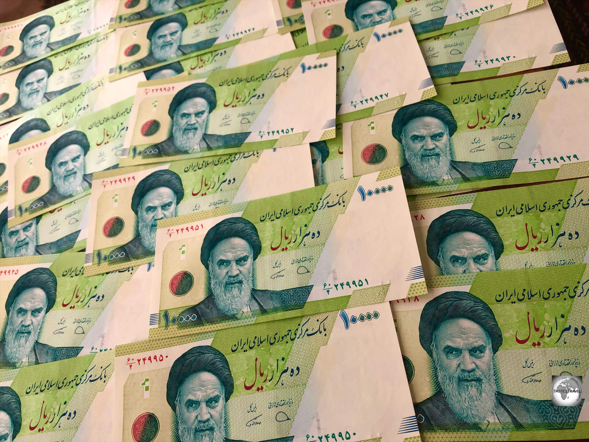


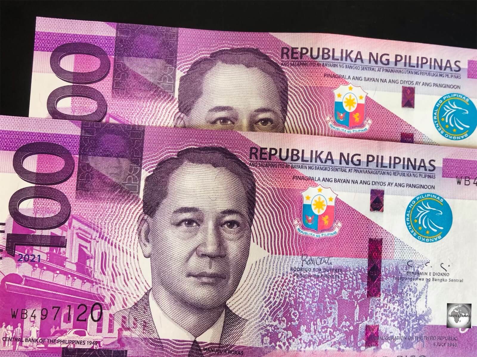


, with my guide, Masoud, relaxing in one of the cool underground rooms, away from the searing desert heat.")


 and a pair of strigils, which were used for scrapping off dirt, perspiration, and oil.")


 and my police escort Muhammad.")


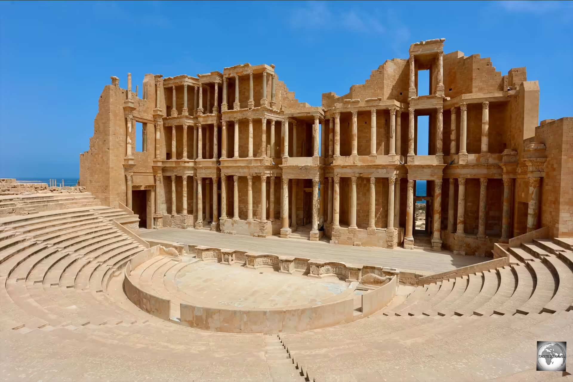


.")


 which was issued at Bujumbura International Airport.")