Kiribati Travel Guide
Welcome to the taste2travel Kiribati Travel Guide!
Date Visited: January 2017
Introduction
Mauri! Welcome to Kiribati (pronounced ‘Kiri-bas’). You will get used to hearing the local version of ‘hello‘ as the friendly locals will greet you at every turn with a warm and welcoming ‘Mauri’.

A view of South Tarawa at low tide.
Located in the central Pacific region, well off the tourist radar in the middle of nowhere is the surprisingly charming atoll nation of Kiribati. Very few people have heard of, much less visited this small country but that’s not surprising given its physical remoteness and lack of development.

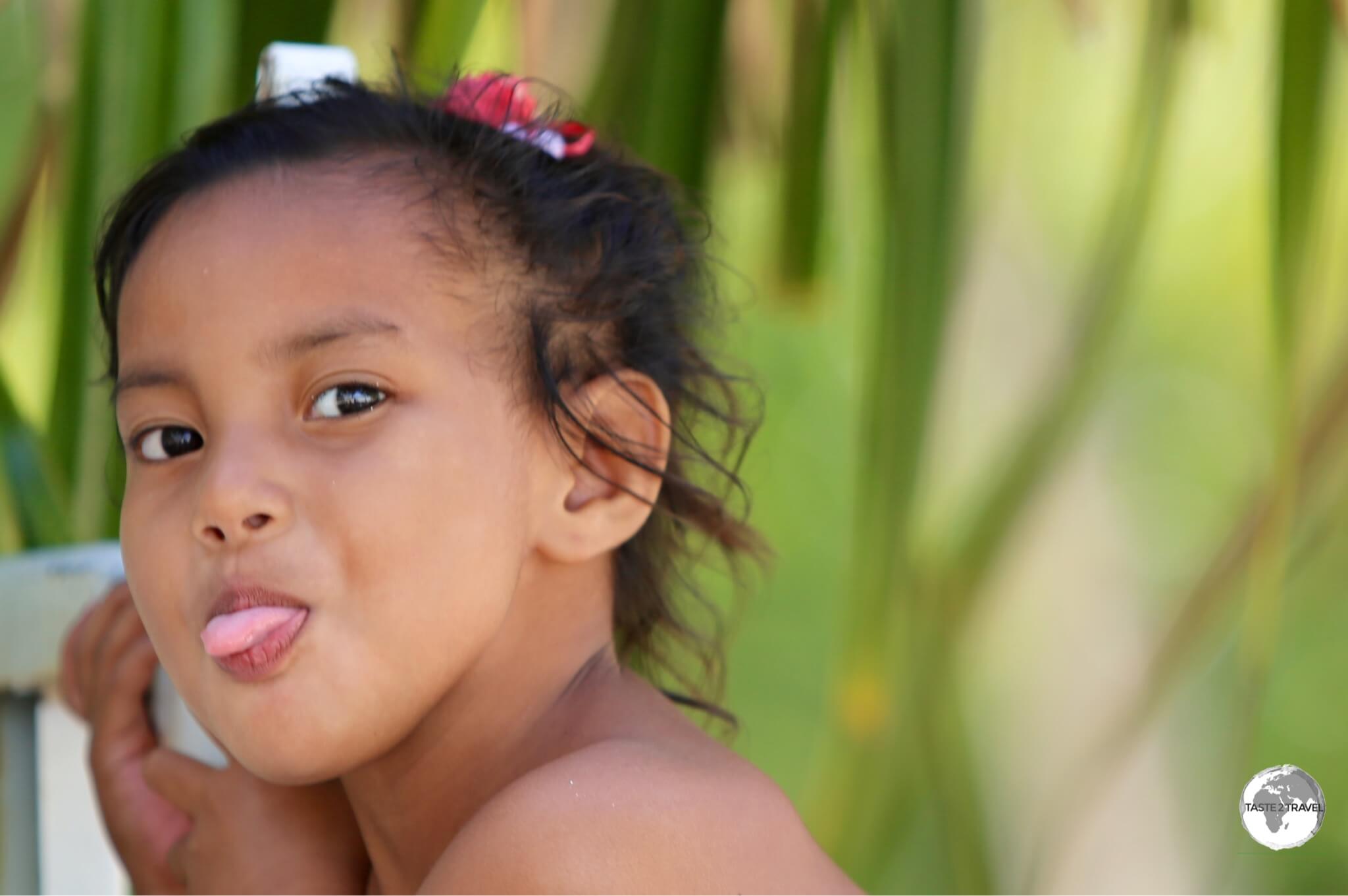
The kids on Kiribati love posing for the camera.
With an annual GDP of just US$1600, Kiribati is the poorest country in the Pacific. This is no Hawaii or Tahiti. With grinding poverty, many people living in makeshift shelters along rubbish-strewn beaches (which are also used as toilets), over-crowded South Tarawa feels more like Africa than the Pacific. Aid organisations are changing things slowly with garbage collections now being implemented and sewage systems being installed.

A Pacific Imperial Pigeon on Kiribati.
If you are in search of a tropical paradise where you can enjoy a relaxing holiday in a plush resort with fine dining options then Kiribati is not for you. There are no resorts or fine dining restaurants and the beaches (at least on South Tarawa) are heavily polluted. South Tarawa is the capital and hub and home to all services and most tourist infrastructure.

A view of Maiana Island with a stone fish trap visible below the shoreline.
South Tarawa is an over-crowded, polluted, bustling, hectic, narrow atoll (just 100 metres wide in places), with one main road running along it connecting a myriad of villages. South Tarawa has a population of 50,000 (50% of the entire population).

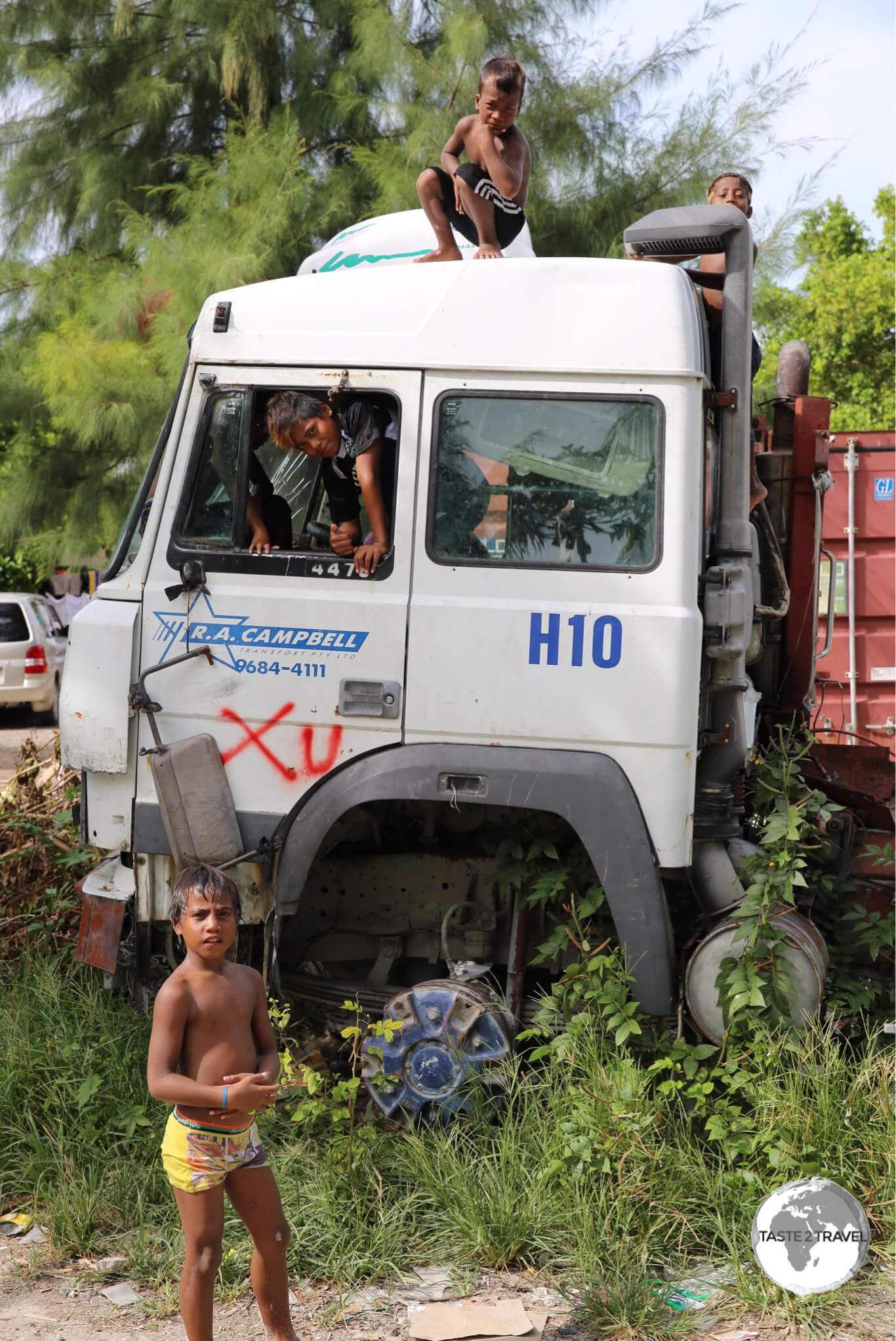
An abandoned truck on Betio island serves as a playground for local boys.
Of the eight islands I visited on my island hop through the central Pacific, Kiribati was the highlight. What makes this place special are the people, they are some of the friendliest folks you’ll meet on this planet.

Rubbish removal is a problem on a remote Pacific atoll.
Without exception, they are warm, welcoming and engaging. From the moment you arrive, you are made to feel welcome. After an amazing week in the company of the I-Kiribati, I was sad to say goodbye.

A colourful Ferris Wheel at Bairiki.
In 2013, the island recorded 5900 visitor arrivals; most of these ‘visitors’ were foreign aid workers. There is a large ex-pat population on the island working for various governmental/ NGO organisations. During my visit, the only other tourists I met were a Dutch couple. I was also the only tourist that they met. The official currency is the Australian dollar.
If you ever have the chance to visit – and you don’t mind roughing it a little – then Kiribati is a truly rewarding destination.

Traditional house on South Tarawa.
Location
Straddling the equator halfway between Hawaii and Australia, Kiribati is comprised of three far-flung island groups (Gilbert, Line and Phoenix). Within these groups, there are 33 low-lying atolls (most of them uninhabited) spread over 3.5 million square kilometres – an area of ocean equivalent in size to the continental United States.
Kiribati
The date line has been diverted around Kiribati to ensure the Line Islands (closer to Hawaii than Tarawa) are in the same time zone (and day) as the rest of the country.

The International Date Line is shown in red.
A Disappearing Nation
The average elevation of Kiribati is less than 2 metres. In places the width of the flat atolls is less than a 100 metres across. Many of the atolls are submerged during King Tides.

Just enough room for a two lane road on South Tarawa.
Rising sea levels and ocean temperatures caused by global warming threaten the people, economy, and very existence of Kiribati – some atolls have already disappeared. In 2014, the government of Kiribati paid US$8.77 million dollars to purchase a 5500 acre freehold estate on Fiji in the event that the nation must relocate.

Low tide on South Tarawa.
History

The national flag of Kiribati features a gold Frigate bird flying over a golden sun with three blue/ white bands representing the ocean and the three island groups.
Formerly a British colony known as the Gilbert Islands, the islands were captured by the Japanese during the Pacific War in 1941. The Japanese spent the next two years establishing bases and fortifying the islands, until Allied forces (led by US Marines) invaded in 1943. The islands of Makin and Tarawa were the sites of major battles. Reminders of the battles on Tarawa can still be seen, especially on the smaller Betio (pronounced ‘Beso‘) Island.

The Gilbert Islands coat of arms, displayed on the window of the General Post Office.
The assault on the island lasted 72 hours and cost approximately 6,000 lives on both sides. The Kiribati Cultural museum screens a short documentary of the American assault on Tarawa. The graphic footage was shot by an embedded camera crew and places the viewer squarely in the middle of the action. The film – “With the Marines at Tarawa” is 19-mins long but well worth watching as it gives you a real sense of the ferocity of the battle. The movie can be viewed from your armchair on YouTube.
The Allied forces eventually liberated the islands. The islands remained under British control until 1979 when they achieved full independence under the new name of Kiribati.

WWII relic – a wrecked Sherman tank laying in the sand on Betio Island.
Sights
Kiribati has few sights as such. The real pleasure in exploring this tiny nation comes from the interactions you have with the friendly locals. I enjoyed walking around with my camera exploring different villages and neighbourhoods on both South and North Tarawa.
Introducing the children of Kiribati…

A young girl on on Betio Island.

Young Kiribati boys playing in the tidal mudflats on South Tarawa.

Young girls on Betio Island.

Young boys on Betio Island.
Discarded WWII relics litter Betio island the location of the ‘Battle of Tarawa’. Reminders of the battle remain scattered around the island and are now used as playgrounds by the local children.

Japanese WWII ruins on the beach at Betio Island.

Japanese Artillery installation on Betio Island.
The best way to find the relics is to follow the coastline around the island. There is a large, abandoned concrete Japanese bunker in the middle of town.

A WWII-era Japanese Bunker on Betio island.
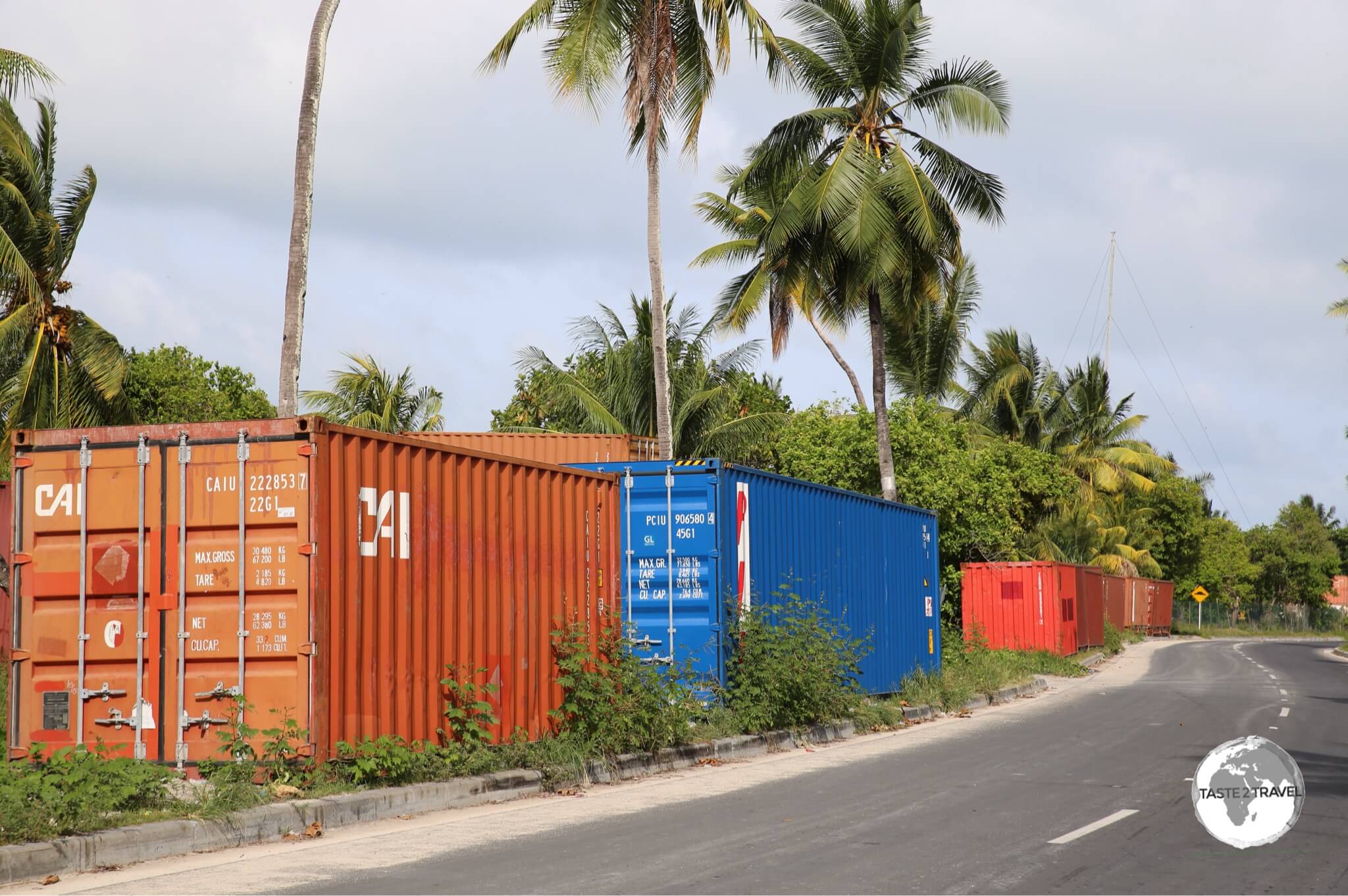
Betio is home to the main port and since this country imports everything there are plenty of containers on the island. However there is no container storage facility at the port so the roadsides of Kiribati are littered with rows of containers. Many shop owners use these containers for temporary storage.

Discarded shipping containers line the streets on Betio Island. There is no real port facility so the containers are left on the roadside and are used for storage by local shop owners.
The Kiribati Cultural Museum in Bikenibeu village is the only museum in the country. It will require about 30 minutes of your time – if it’s open. I turned up on two different occasions during the posted ‘opening hours’ to find the museum was closed. On the third attempt I got lucky. The highlight of the museum is the overview of the battle of Tarawa. There is a big flat screen TV where you can sit and watch the 19-min documentary – With the Marines at Tarawa.

Fishing is the main pastime on all the islands of Kiribati.
As with other Pacific islands, the hub of each village on Kiribati is the community meeting house – known as a ‘Maneaba‘. These are similar to Marae’s in New Zealand. The Maneaba are used for all community events and the cool lino-covered floors are a popular place to relax in the mid-day heat. The most traditional and picturesque Maneaba is in the village of Bonriki (near to the airport).

A traditional Maneaba (meeting house) in Bonriki village.
With ninety-six percent of the population being Christian (more than 50% Catholic), there are some impressive churches on South Tarawa. Unlike churches elsewhere, there are no pews here. Instead, just like the Maneaba, the locals sit on the cool lino-covered floor.

Interior of St. Paul’s church on Betio Island.
Separated from South Tarawa via a narrow channel – which can be crossed by foot at low tide – is the much quieter, more traditional island of North Tarawa. There is a daily ferry which connects the island to South Tarawa (Bairiki port). Accommodation options are limited to a few simple guest houses.

Low tide on North Tarawa.
Accommodation
Most accommodation options are located on South Tarawa but even here options are limited. A good place to start your search is the accommodation page on the Kiribati Tourism website.
Utirerei Motel
While on South Tarawa, I stayed at Utirerei Motel, which is located in Ambo village. This friendly, family-run hotel is staffed by enthusiastic staff who keep the place spotlessly clean and go out of their way to ensure your stay is memorable. Breakfast is included in the reasonable rate and the restaurant is one of the better places to eat on the island. You can book rooms using booking.com
Betio Lodge
Betio Lodge is another popular choice on Tarawa. The hotel includes a good restaurant and a cafe equipped with a proper espresso machine and the #1 barista in the country. The hotel is home to a fishing club which holds occasional tournaments.
Dreamers Kiribati Guest House
Located near Parliament House in the village of Ambo, Dreamers Kiribati Guest House offers three self-contained rooms with breakfast for AUD$120.
Airport transfers are also included in the nightly room rate.
Dinner is also available at AUD$15 per night.
Eating Out
Dining options are limited. Most locals cannot afford to dine out and there are few tourists requiring fancy restaurants. There are restaurants at the main hotels and also a few located along the main road.

BBQ fish at a roadside fish market.
The best café on Tarawa is Chatterbox, which is located inside a travel agent on the main road in Bikenibeu village. Everything here is very good from the latte’s and cappuccino’s to the food. This café is home to one of two espresso machines on Kiribati. Food supply on the island is erratic so the menu is kept simple. They also offer home made banana bread and other cakes. The whole place is kept clean and the air-con keeps things refreshingly cool. They also have a souvenir shop selling locally made handicrafts and a travel agent.
The one other place with decent espresso coffee is the café at Betio Lodge. The barista here (Peter) makes the best coffee on the island. Luckily it is at the other end of Tarawa from Chatterbox so regardless of which end of the island you are visiting – you are never far from a good coffee.
There is a roadside fish market near to the village of Bairiki. Do not be surprised to see live turtles being sold here.

Octopus for sale at a roadside fish market on South Tarawa.
Visa Requirements

Kiribati Passport Stamps.
Some nationalities require visas for Kiribati – check your visa requirements prior to arrival.
Getting There
By Air

Arrival at Bonriki International Airport, the gateway to Kiribati.
International flights arrive at sleepy Bonriki International airport on Tarawa.
The following airlines provide connections to/from Tarawa (TRW):
- Air Kiribati – flights to/from Abaiang, Abemama, Butaritari, Funafuti, Kuria, Maiana, Nadi, Nonouti, Tabiteuea North
- Solomon Airlines – flights to/from Brisbane, Honiara
- Fiji Airways – flights to/from Nadi
- Nauru Airlines – flights to/from Majuro, Nauru, Pohnpei
Located in the car park of the airport is one of the best dining options on the island. Known as ‘Starbucks‘ – but so much better than it’s American namesake – the owner of this outdoor restaurant (actually a corrugated-iron shack) produces great tasting, delicious food over a gas cooker. It’s all wonderfully simple and unpretentious. Her banana bread is the best on the island.

The terminal at Bonriki International Airport.
Getting Around
Air

An Air Kiribati inter-island flight arriving at Bonriki Airport.
Domestic air services to the remote outer islands in the Gilbert Group are provided by Air Kiribati from their base at Bonriki Airport. Tickets are so reasonably priced (I paid A$56 return to Maiana Island), you can spend some of your time doing joy flights to different islands.

My Air Kiribati flight tickets to Maiana Island – AUD$28 each way.
The helpful station manager at Bonriki Airport will explain flight options from the schedule, take your payment (cash only) and issue you a hand-written ticket. Like everything on Kiribati, the airport operation is very friendly, low-key and casual.

My inexpensive ‘joy flight’ ticket with Air Kiribati.
Some flights offer a circuitous, meandering journey stopping at four or five different islands before returning to Bonriki airport.

Air Kiribati Route Map
Most of the outer islands have no infrastructure or services so they don’t lend themselves to overnight stays unless you are fully self-sufficient. If you’ve ever dreamed of being Robinson Crusoe, the outer islands await you.

On approach to Maiama island – one of the outer islands.
Runways on the outer islands are simple dirt strips. The arrival of a flight from Tarawa is something that creates an air of excitement and you can expect most locals to be at the tiny airport to greet the plane and its passengers. The arrival of a tourist dials up the excitement level considerably.

Children playing at Maiana airport.
Most tourists don’t make it beyond South Tarawa so you can expect quite a welcome along with offers of accommodation if you wish to stay – perfect for those seeking out a Gauguin-esque experience.

Friendly local girls on Maiana island.
Seat allocation is not a problem on domestic flights, which operate more like an inter-island bus service. Children are nursed on laps, a family of four will occupy a twin seat – you just need to ensure your ventilation is working well.

Plenty of room for everyone aboard the over-filled Air Kiribati flight from Maiana Island to Bonriki.
Bus
Most of the 50,000 inhabitants of South Tarawa rely on privately operated mini-buses, which shuttle back and forth along the one main road on the atoll. Fares are generally less than A$1. Despite running frequently, the buses are normally over-crowded (a la sardine can) but provide a great way to meet the locals and contract the latest cold or flu.
The Australian Government and Asian Development Bank (ADB) have recently spent A$60 million upgrading the main road on the island. This has greatly improved life for the inhabitants and introduced speed humps to the island 🙁

My rental scooter on the newly upgraded road on South Tarawa.
Taxi
There are no taxis on Kiribati. Hotels offer shuttle service from the airport.
Car/ Scooter
Hotels on South Tarawa can provide rental cars and scooters. I rented a scooter at A$30 per day from the George Hotel on Betio.
That’s the end of my Kiribati Travel Guide.
Safe Travels!
Darren
Follow me on Instagram:
[instagram-feed feed=1]
Further Reading
Other travel reports from the Pacific region:
- American Samoa
- Central Pacific Island Hopping
- Chuuk
- French Polynesia
- Galapagos Islands
- Guam
- Kosrae
- Marshall Islands
- Nauru
- New Caledonia
- Palau
- Papua New Guinea
- Pohnpei
- Samoa
- Solomon Islands
- Tokelau
- Tonga
- Tuvalu
- Vanuatu
Kiribati Travel Guide Kiribati Travel Guide Kiribati Travel Guide Kiribati Travel Guide Kiribati Travel Guide Kiribati Travel Guide Kiribati Travel Guide Kiribati Travel Guide
Author: Darren McLean
Darren McLean is an Australian, full-time, digital nomad who has spent 37 years on a slow meander around the globe, visiting all seven continents, 192/ 193 UN countries and 245/ 251 UN+ countries and territories.
He founded taste2travel to pique one’s curiosity and inspire wanderlust.


Amazing!!!Good luck for more adventures,keep safe always Darren???
Thanks Maybel ?
Very interesting I thoroughly enjoyed living your experience through your blog.
It wonder why they do not use the shipping containers for housing
Hi Mum,
Thanks for your response. To answer your question – most of the containers are eventually returned to the shipping company. Some containers do remain on the island and are used for all sorts of things from storage to fencing to house foundations.
I love the way you write your blogs… Objectively and nicely critical, yet passionate about things that matter… And the photos are superb!
Thank you so much for your kind words Jane…. I’m pleased you are enjoying the blogs.