Tag - Pacific Islands

Wallis and Futuna Photo Gallery

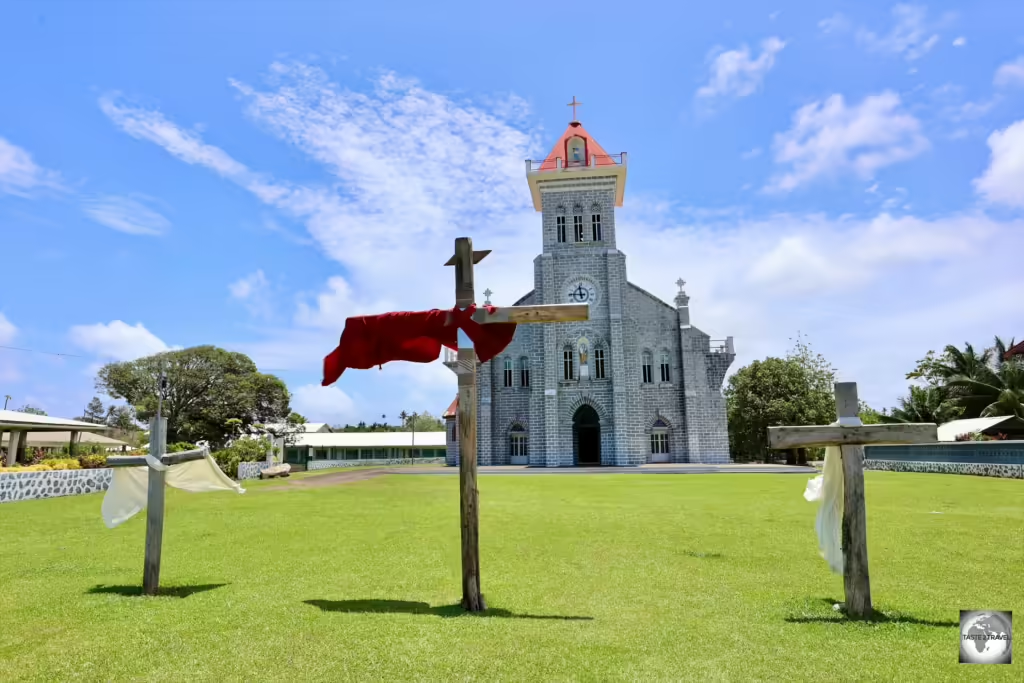
The Cathedral of Our Lady of the Assumption in Mata-Utu.

Wallis and Futuna Photo Gallery

This is a Wallis and Futuna Photo Gallery from taste2travel.

To read about this destination, please refer to my Wallis and Futuna Travel Guide.


All images are copyright! If you wish to purchase any images for commercial use, please contact me via the Contact page.


About taste2travel!

Hi! My name is Darren McLean, the owner of taste2travel.

I’ve been travelling the world for 36 years and, 241/251 countries and territories (189/193 UN countries), and seven continents later, I’m still on the road.

Taste2travel offers travel information for destinations around the world, specialising in those that are remote and seldom visited. I hope you enjoy my content!

Ever since I was a child, I have been obsessed with the idea of travel. I started planning my first overseas trip at the age of 19 and departed Australia soon after my 20th birthday. Many years later, I’m still on the road.

In 2016, I decided to document and share my journeys and photography with a wider audience and so, taste2travel.com was born.

My aim is to create useful, usable travel guides/ reports on destinations I have visited. My reports are very comprehensive and detailed as I believe more information is better than less. They are best suited to those planning a journey to a particular destination.

Many of the destinations featured on my website are far off the regular beaten tourist trail. Often, these countries are hidden gems which remain undiscovered, mostly because they are remote and difficult to reach. I enjoy exploring and showcasing these ‘off-the-radar’ destinations, which will, hopefully, inspire others to plan their own adventure to a far-flung corner of the planet.

I’m also a fan of travel trivia and if you are too, you’ll find plenty of travel quizzes on the site.

Photography has always been a passion and all the photos appearing in these galleries were taken by me.

If you have any questions or queries, please contact me via the contact page.

I hope you this gallery and my website.

Safe travels!

Darren


Follow me on Instagram: 

[instagram-feed feed=1]

Wallis and Futuna Travel Guide

Talietumu is an ancient Tongan fort on Wallis Island.

Wallis and Futuna Travel Guide

This is a Wallis and Futuna Travel Guide from taste2travel.com

Date Visited: October 2024

Introduction

The remote French territory of Wallis and Futuna lies in a not-so-remote corner of the Pacific Ocean, with tourist hubs such as Fiji just 786 km (488 mi) to the southwest.

Despite being an off-the-radar destination, the French territory of Wallis and Futuna offers an authentic Pacific Island travel experience, well away from the tourist hordes.

With little in the way of tourist facilities and services, no public transport or taxis, visitors are very much left to their own devices, with a rental car being the only way to explore the islands.

Saint Joseph's church dominates the village of Mala'efo'ou on Wallis Island.

Saint Joseph’s church dominates the village of Mala’efo’ou on Wallis Island.

The islands are home to a small community of 11,558 souls (8,333 on Wallis Island and 3,225 on Futuna Island) who live in traditional villages which remain largely undisturbed by the modern world.

Views of two of the many offshore islets, which lie in the lagoon which surrounds Wallis Island.

Views of two of the many offshore islets, which lie in the lagoon which surrounds Wallis Island.

Villages are dispersed on the islands, mainly on the coast, and the islanders enjoy an unhurried way of life which revolves around church services and lazy Sunday family lunches.

Currently, the only airline which operates flights to Wallis and Futuna, Aircalin, flies twice a week (Saturday and Monday) from their base in Noumea, via Nadi.

A statue of Jesus, bedecked in many <i>leis</i>, in Leava, Futuna Island.

A statue of Jesus, bedecked in many leis, in Leava, Futuna Island.

Due to its monopoly operation, which Aircalin jealously guards, airfares are kept high and would discourage all but the keenest of travellers from flying to the islands.

As with other French territories, travel costs on Wallis and Futuna are very high when compared to neighbouring destinations such as Fiji and Samoa.

Wallis and Futuna is not a budget-friendly destination!

Another statue of St. Joan of Arc, dressed in a <i>lei</i> holding her flag.

A statue of St. Joan of Arc, dressed in a lei holding her flag.

Although a French territory, unlike anywhere else in the Francophone world, Wallis and Futuna are ruled by three kings who have much control over the running of the islands.
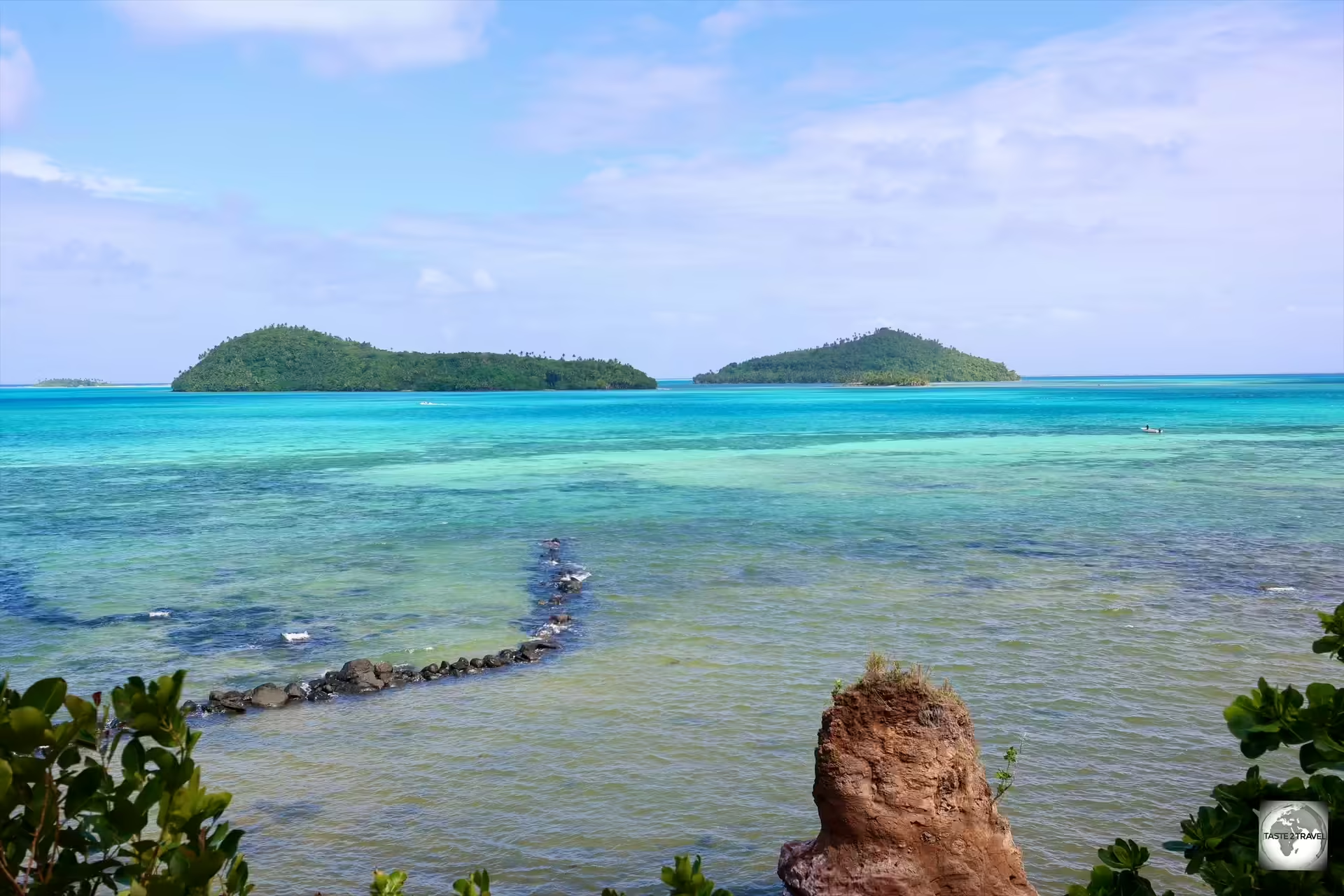
A view of the lagoon and offshore islets from Wallis Islands.

A view of the lagoon and offshore islets from Wallis Islands.

The number of French expatriates in Wallis and Futuna has always been small. Of the total resident population on the islands, only a small number are of European descent.

Because of their relative isolation, Wallis and Futuna attracts few tourists. For those who do make the voyage, Wallis and Futuna offers a unique and authentic travel experience.

Location

Wallis, 98600, Wallis and Futuna

Wallis and Futuna is a French overseas collectivity located in the South Pacific Ocean, about two-thirds of the way from Hawaii to New Zealand.

It lies 786 km (488 mi) northeast of Fiji, 446 km (277 mi) west of Samoa, and 961 km (597 mi) southeast of Tuvalu.

This remote French territory consists of three main islands, Wallis, Futuna and Alofi, and a number of smaller islets.

A map of the South Pacific, showing the location of Wallis and Futuna Islands.

A map of the South Pacific, showing the location of Wallis and Futuna Islands.

The islands are volcanic in origin, with low hills, and fringing reefs.

Wallis Island (Uvea) is the largest and most populous of the islands, located in the northern part of the territory.

Artwork showing a view of two offshore <i>motu's</i> from Wallis Island.

Artwork showing a view of two offshore motu’s from Wallis Island.

The island is surrounded by a lagoon and a barrier reef, which makes it ideal for fishing and water activities.

The wide lagoon around Wallis, and its 22 smaller surrounding islets (motu’s) are confined by a large barrier reef and smaller fringing reefs

On final approach to Wallis Island which is surrounded by a fringing reef.

On final approach to Wallis Island which is surrounded by a fringing reef.

The smaller and more rugged Futuna Island is located about 230 kilometers southwest of Wallis Island. It’s part of a twin-island group with Alofi Island.

The highest point is Mont Puke, also known as Mont Singavi which is located on Futuna Island and rises to a height of 524 metres (1,719 ft).
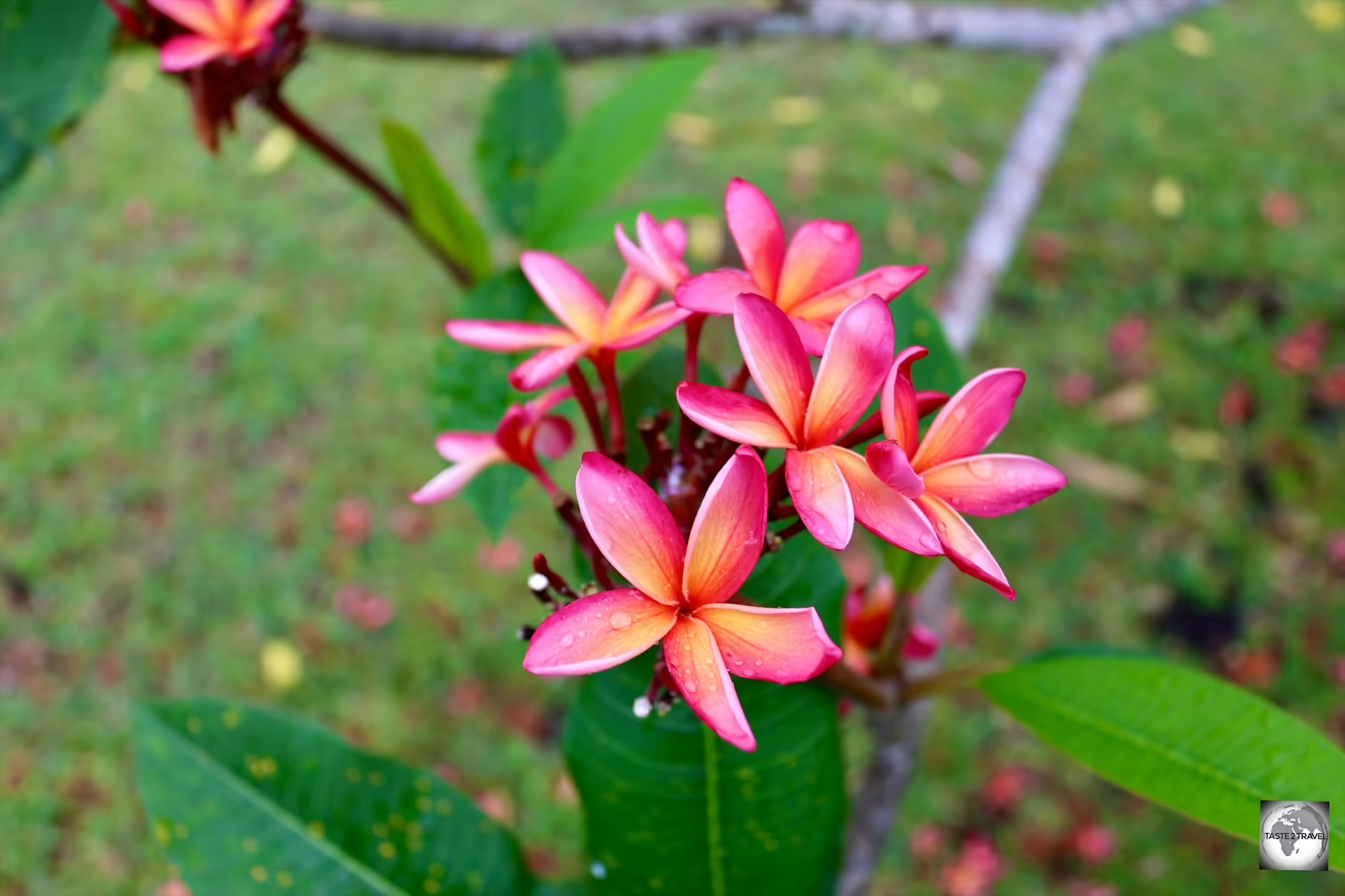
No shortage of colourful tropical flowers, such as frangipani's, on Wallis and Futuna.

No shortage of colourful tropical flowers, such as frangipani’s, on Wallis and Futuna.

Alofi Island lies just southeast of Futuna and, due to a lack of fresh water, is home to just one hardy inhabitant.

History

Wallis Island was originally settled 3,400 years ago by Austronesian explorers.

It’s believed the original ancestors of the Polynesians, the Austronesians, left Taiwan 4,000 years ago, stepping from island to island across the Pacific, all the way to Easter Island (click to view my Easter Island Photo Gallery).

Fast forward many millennia to the 15th century, when the powerful Tongan empire extended its influence to Uvea (now Wallis Island), establishing a chiefdom system which remains to this day.

Built around 1450, Talietumu is an ancient Tongan fort and one of the highlights of Wallis Island.

Built around 1450, Talietumu is an ancient Tongan fort and one of the highlights of Wallis Island.

One of the key sites on Wallis Island, Talietumu is an ancient Tongan fort which was built during the Tongan period.

The fort, built around 1450 during the expansion of the Tu’i Tonga Empire, was the last holdout of the Tongans on Uvea until they were defeated.

While the Tongans occupied Uvea, the Samoans settled on Futuna in the 17th century, leading to the formation of the current kingdoms in the 18th century.

In 1767, British navigator, Captain Samuel Wallis, visited Uvea and gave his name to the island.

Although the first European discoveries of the island were made by the Dutch and the British in the 17th and 18th centuries, it was the French who declared a protectorate over the islands in 1842.

In 1959, the inhabitants of the islands voted to become a French overseas territory.

People

Waiting for the flight at Futuna Airport.

Waiting for the flight at Futuna Airport.

Population

The islands of Wallis and Futuna are home to 11,558 souls (8,333 on Wallis Island and 3,225 on Futuna Island). It is a population in decline!

During the 2000’s, the islands witnessed a large exodus of its young working-age population as many left for better work and study opportunities mostly in New Caledonia and France.

The inhabitants of Wallis and Futura are ethnically Polynesian.

The inhabitants of Wallis and Futura are ethnically Polynesian.

The overall population in 2003 was 14,944, and, as of the last census in 2023, is currently at 11,558.

Due to limited economic opportunities, a significant number of Wallisians and Futunans have migrated to New Caledonia, where a large diaspora exists, often sending remittances back to their families on the islands.

Lifestyle

The inhabitants of this remote Pacific paradise live in close-knit communities where family ties and communal responsibilities are highly valued. Extended families often live together, and there is a strong sense of mutual support.

Most of the population lives in rural villages, with subsistence farming, fishing, and small-scale agriculture being common livelihoods. The pace of life is generally slow and community-focused.

The people of Wallis and Futuna are known for their warm hospitality, strong community bonds, and deep respect for their cultural traditions and heritage. Despite the challenges of living in a remote location, they maintain a resilient and vibrant cultural identity.

Polynesian Culture

A painting, in the Mata-Utu post office, depicting a traditional Kava ceremony.

A painting, in the Mata-Utu post office, depicting a traditional Kava ceremony.

Following centuries of occupation by the Tongans and Samoans, the Wallisians (Uveans) and Futunans, have a rich cultural heritage deeply rooted in Polynesian traditions.

This has been combined with influences from the French colonial history, most notably the introduction of the Catholic religion which is a central part of life on the islands.

The majority of the population is of Polynesian descent, sharing cultural and linguistic ties with other Polynesian groups such as Samoans, Tongans, and Tahitians.

There are two main cultural groups – Wallisians (Uveans) on Wallis Island and Futunans on Futuna and Alofi Islands. While they share similarities, each group has its own distinct language, customs, and identity.

Language

While all inhabitants of Wallis and Futuna speak French, on Wallis Island, the everyday language spoken by the local inhabitants is Wallisian (Uvean), while on Futuna Island, the locals speak Futunan.

Religion

Spectacular churches can be found in most villages throughout Wallis and Futuna.

Spectacular churches can be found in most villages throughout Wallis and Futuna.

As for religion, the vast majority of the population practices Roman Catholicism, which plays a central role in the community’s daily life.

A view of the interior of the Chapel of Saint Joan of Arc in Halalo village.

A view of the interior of the Chapel of Saint Joan of Arc in Halalo village.

For many locals, each day starts by attending a 5 a.m. mass at their village church. Churches can be found in most villages!

The Cathedral of Our Lady of the Assumption in Mata-Utu.

The Cathedral of Our Lady of the Assumption in Mata-Utu.

The influence of the Catholic church is strong, with many cultural and social events centred around religious practices and celebrations.

Monarchy

A view of the royal palace in Mata-Utu, the capital of Wallis Island.

A view of the royal palace in Mata-Utu, the capital of Wallis Island.

In terms of social structure, society is organised around traditional chieftaincies, with each island having its own hierarchical system.

Chiefs, or “kings,” hold significant influence over local affairs, often working alongside French-appointed administrators.

The original system of monarchy on Uvea (Wallis Island) was established by the Tongans under the Tuʻi Tonga dynasty. This dynasty ruled over Uvea from approximately 1400–1600 (CE).

There are three traditional kingdoms in the territory, all of which have a degree of political power. Those kingdoms include: Alo and Sigave (both on Futuna Island) and Wallis.


Did you know? 

Wallis and Futuna is the only French territory ruled by a Monarch!

While France famously abolished its monarchy on the 24th of February 1848, Wallis and Futuna have been allowed to maintain their royal families.

Under a 1961 statute, France agreed to maintain three monarchies (one in Wallis and two in Futuna) in which customary rights exist and co-exist within French law.

The kings are remunerated by the French Government.

Each customary monarchy consists of a king (“Lavelua”), appointed by the royal families, assisted by a prime minister and a ‘chefferie‘, which is comprised of the village chiefs.

The kings are responsible for managing land and familial disputes and for religious and customary ceremonies.


How is the king chosen?

The title is not hereditary, but given to a person chosen from a group of royal families.

The discussions on who to crown can take months or even years.

The secession issue is often fraught, and, in April of 2016, a standoff on Wallis Island made international news headlines due to a disagreement over who should be crowned as the next king.

At the time, the island chiefs named Tominiko Halagahu as king, however, a rival chief council preferred another candidate – Patalione Kanimoa.

In order to stop the coronation of Tominiko Halagahu, supporters of Kanimoa blockaded the royal palace compound in Mata-Utu.

After almost two months of dispute, Kanimoa was officially confirmed by the administrator-superior of the French Republic as king on 3 June 2016, and has been reigning over the kingdom ever since.

Flag

Flag of Wallis and Futuna

Flag of Wallis and Futuna

The flag of Wallis and Futuna is distinctive and represents the territory’s connection to France as well as its local identity.

The flag combines elements of the French national flag and local symbolism.

The three constituent kingdoms of Wallis and Futuna (Alo, Sigave and Uvea) have separate royal standards.

The flag of Uvea, flying outside the royal palace in Mata'Utu.

The flag of Uvea, flying outside the royal palace in Mata’Utu.

The flag’s design features the iconic French Tricolor, or Tricolore, in the upper left corner. The Tricolor consists of three vertical stripes of blue, white, and red.

This represents Wallis and Futuna’s status as a French overseas collectivity.

The constituent flag of the Kingdom of Uvea.

The constituent flag of the Kingdom of Uvea.

The rest of the flag is a red field, which takes up the majority of the design. On this red background, there is a white cross that is placed toward the right side of the flag.

The French flag, flying alongside the flag of Uvea in Mata'Utu.

The French flag, flying alongside the flag of Uvea in Mata’Utu.

This cross is a thin, equal-armed cross, which symbolises Christianity, particularly the Roman Catholic faith, which is predominant in the territory.

Philately

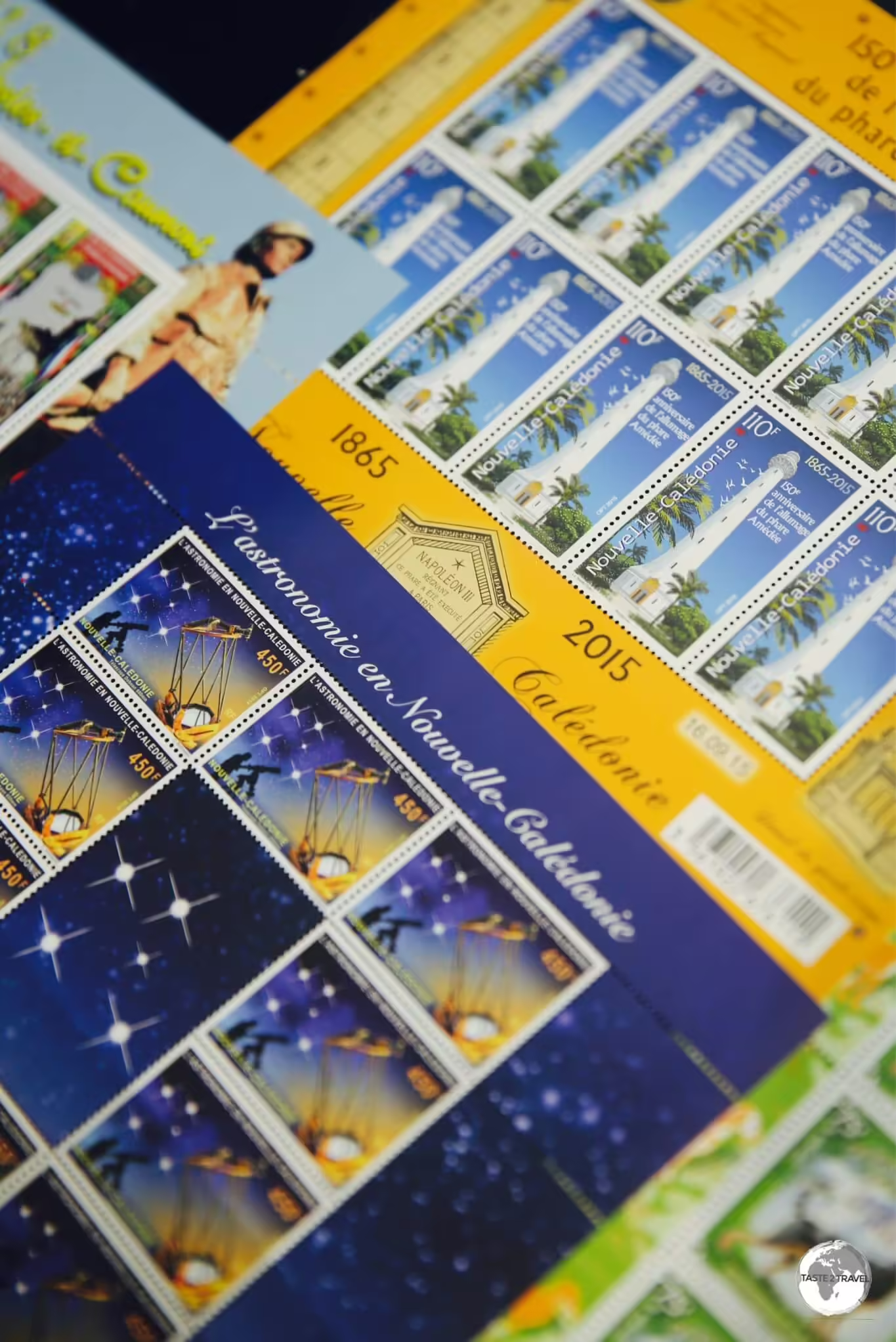
The stamps of Wallis and Futuna are popular among philatelists around the world.

The stamps of Wallis and Futuna are popular among philatelists around the world.

Wallis and Futuna issues its own postage stamps. These stamps often reflect the unique culture, history, and natural beauty of the islands.

The stamps of Wallis and Futuna feature local marine life.

The stamps of Wallis and Futuna feature local marine life.

Popular among philatelists worldwide, the stamps of Wallis and Futuna highlight the cultural heritage of the islands, the fauna and flora – especially marine life, historical events, natural landscapes and much more.

The stamps of Wallis and Futuna showcase local culture and traditions.

The stamps of Wallis and Futuna showcase local culture and traditions.

These stamps are not only functional but also serve as a means of preserving and showcasing the unique identity of Wallis and Futuna to the world. Collectors often value them for their artistic and cultural significance.

Post Office
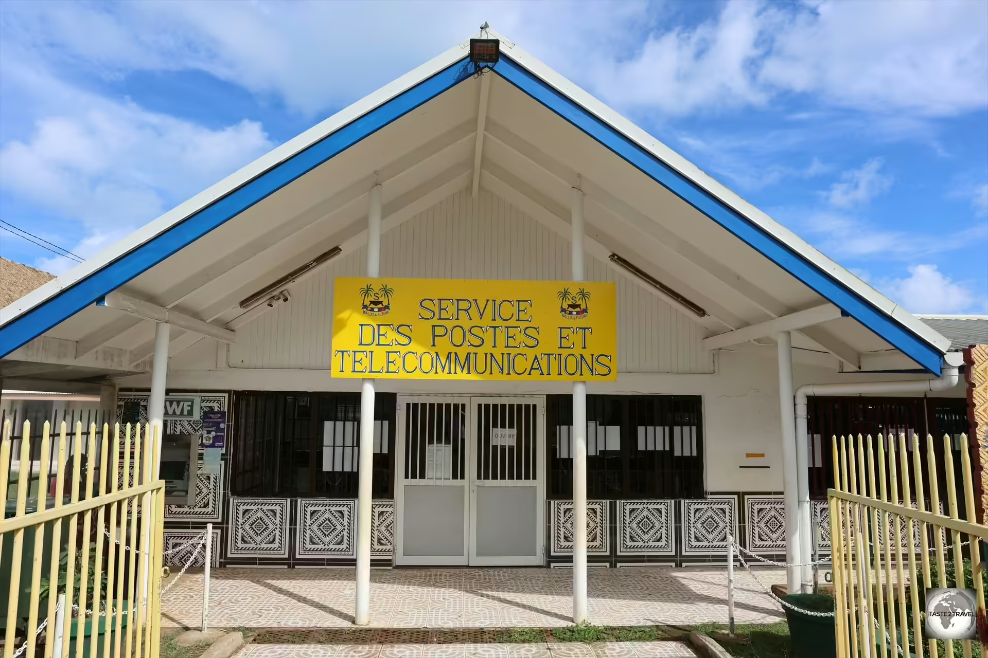
Stamps, post cards and SIM cards can be purchased from the main post office in Mata-Utu.

Stamps, post cards and SIM cards can be purchased from the main post office in Mata-Utu.

Located on the waterfront, across the road from the Royal Palace, the Mata-Utu post office offers philatelic sales (in an adjacent building), along with post cards and SIM cards.

The <i>'Service des Postes et des Télécommunications (SPT)'</i> sign outside the Mata-Utu post office.

The ‘Service des Postes et des Télécommunications (SPT)’ sign outside the Mata-Utu post office.

As in other French territories, the post office is known as “Service des Postes et des Télécommunications”, which is always abbreviated as SPT.

The post office sells stamps and post cards.

The post office sells stamps and post cards.

The friendly and helpful staff assisted me with the purchase of stamps and post cards.

Posting my postcards at the post office in Mata-Utu.

Posting my postcards at the post office in Mata-Utu.

Any postal items can be deposited into the post box which is built into the front wall of the post office.

Wallis Island main post office (SPT headquarters) contacts:

The post office on Futuna Island is located in the main town of Leava.

The post office on Futuna Island is located in the main town of Leava.

Postal services on Futuna Island are offered by SPT at the main post office in Leava.

Futuna Island Post Office Branch contacts:

  • Address: Lieu-dit Faletoa, in Leava (Sigave)
  • Telephone: (+681) 72 36 00
  • Opening hours: Monday to Thursday 7.30 a.m. – 2.30 p.m.; Friday 7.30 a.m. – 1.30 p.m.

SIM Cards

The post office (SPT) is responsible for the sale of SIM cards and mobile top-ups. The local mobile network is called Manuia (by SPT)

When I enquired about purchasing a SIM card, post office staff quoted a price of XPF 5,000 (US$45.32) which includes XPF 3,000 credit and 10 domestic SMS, valid for 90 days.

Current data package rates are published on the SPT website – https://spt.wf/

I declined the offer and chose instead to use free WiFi at my guest house and at local restaurants such as Beach Club and Maloccino.

Currency

The Pacific Franc is used in the French Pacific territories of New Caledonia, French Polynesia and Wallis and Fortuna.

The Pacific Franc is used in the French Pacific territories of New Caledonia, French Polynesia and Wallis and Fortuna.

The official currency of Wallis and Futuna is the CFP franc (Central Pacific Franc), abbreviated as XPF.

The CFP franc is also used in other French overseas collectivities in the Pacific, such as French Polynesia and New Caledonia.
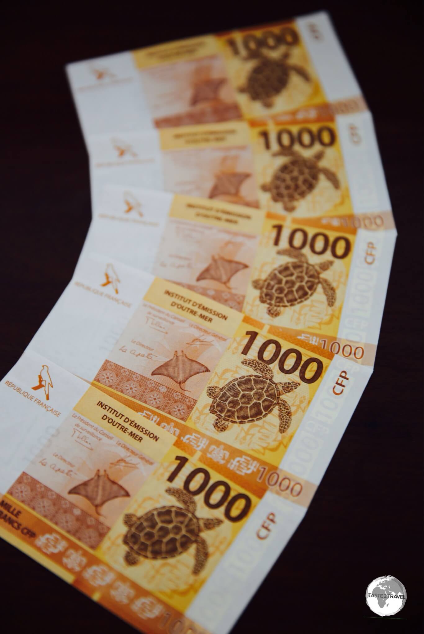
The Pacific Franc is legal tender in French Polynesia, New Caledonia and Wallis and Futuna.

The Pacific Franc is legal tender in French Polynesia, New Caledonia and Wallis and Futuna.

Exchange Rate

  • The CFP franc is pegged to the euro (EUR) at a fixed exchange rate of 1 EUR = 119.33 XPF.
  • Currently (October 2024), US$1 = 107.25 XPF. (Click to view the current rate.)

Banknotes and Coins

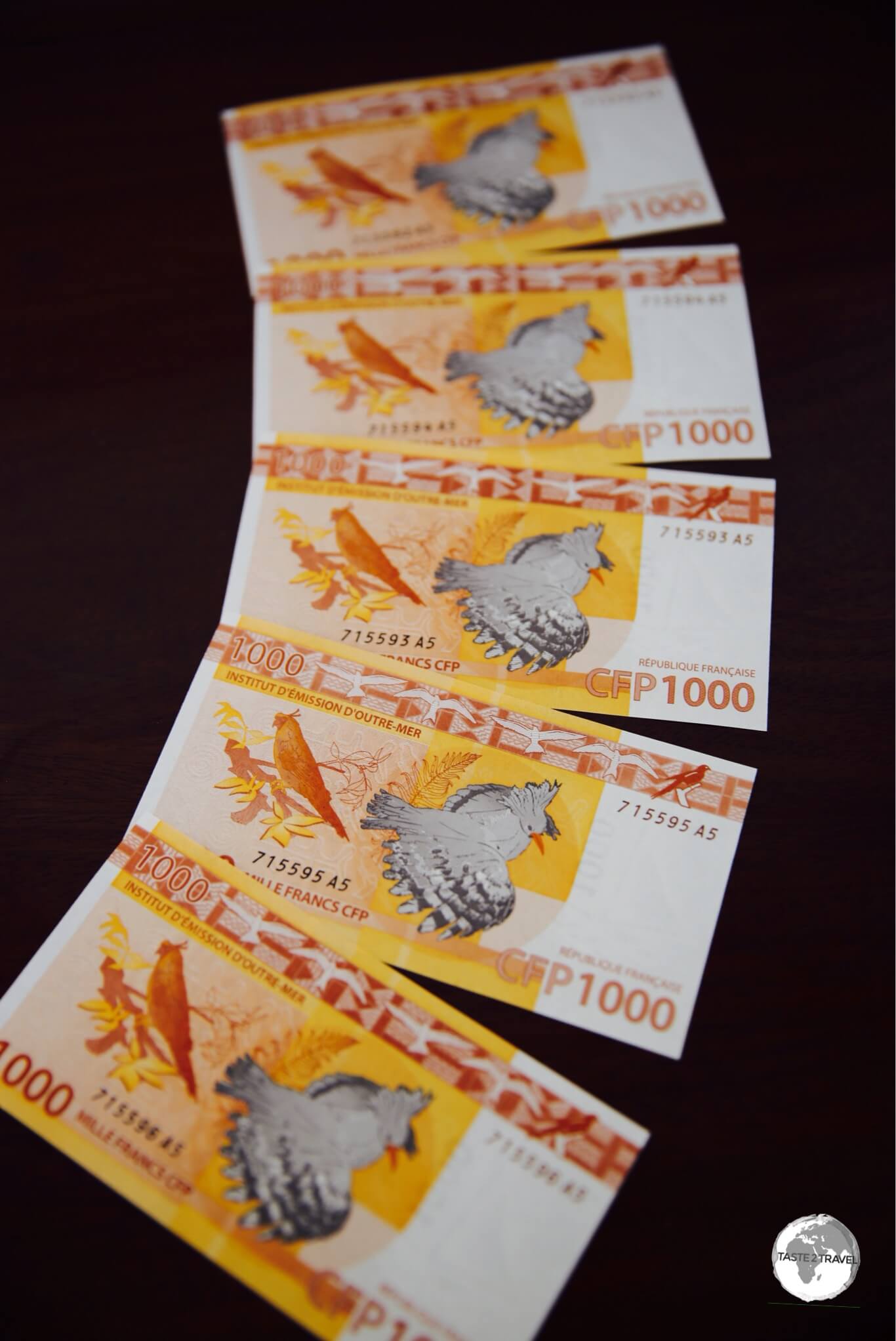
The currency includes both coins and banknotes. Coins come in denominations of 1, 2, 5, 10, 20, 50, and 100 francs, while banknotes are available in denominations of 500, 1,000, 5,000, and 10,000 francs.
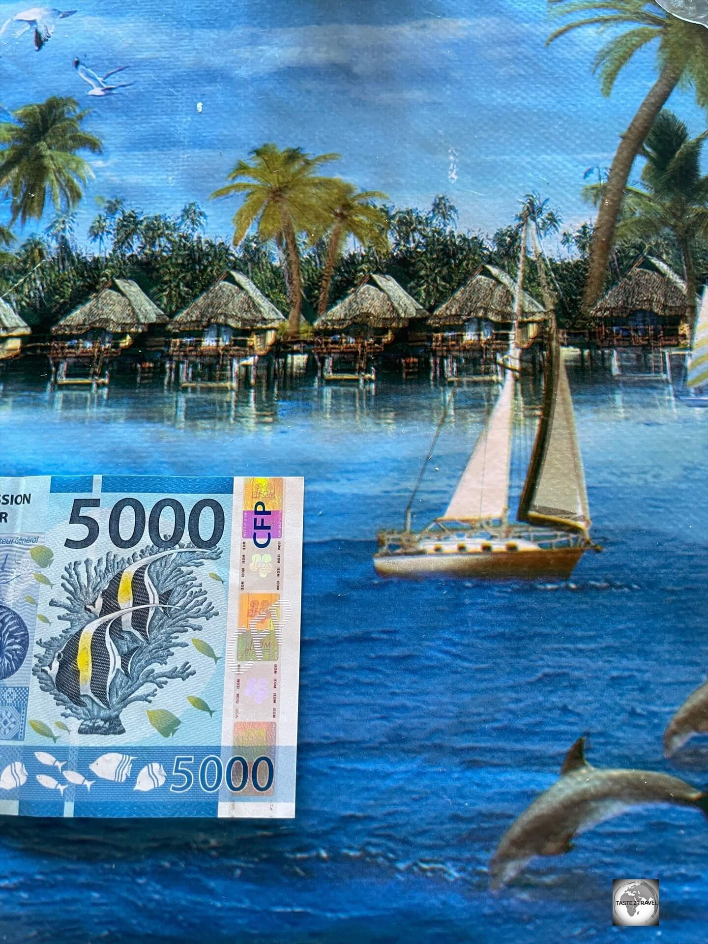
The Pacific Franc (CFP) is the official currency of Wallis and Futuna.

The Pacific Franc (CFP) is the official currency of Wallis and Futuna.

The CFP franc is issued by the Institut d’émission d’Outre-Mer (IEOM), which is the central bank responsible for monetary policy in the French Pacific territories.

Banking Services

Banking services on Wallis and Futuna are provided by the Bank of Wallis and Futuna (BWF).

Banking services on Wallis and Futuna are provided by the Bank of Wallis and Futuna (BWF).

Banking services on Wallis and Futuna are provided by the Bank of Wallis and Futuna (BWF), a subsidiary of BNP Paribas.

The one branch of BWF can be found in the small shopping arcade behind the SEM Supermarket.

Opening Hours: BWF bank is open between 8:00 a.m. and 12:30 p.m., Monday to Friday.

One of two ATMs on Wallis Island can be found at the main post office.

One of two ATMs on Wallis Island can be found at the main post office.

The bank operates two ATMs on Wallis and another on Futuna.

The ATMs on Wallis are located at the main post office in Mata-Utu and at the entrance to the SEM Supermarket complex.

Credit Cards

Credit cards are widely accepted on Wallis and Futuna with cash rarely needed.

Costs

Arriving on a very wet Futuna Island, where a return flight ticket from Wallis costs XPF 29,800 (US$277.85).  

Arriving on a very wet Futuna Island, where a return flight ticket from Wallis costs XPF 29,800 (US$277.85).

Not Cheap!

With extortionate costs for everything, Wallis and Futuna is not a destination for backpacker’s or any traveller who is on a strict budget.

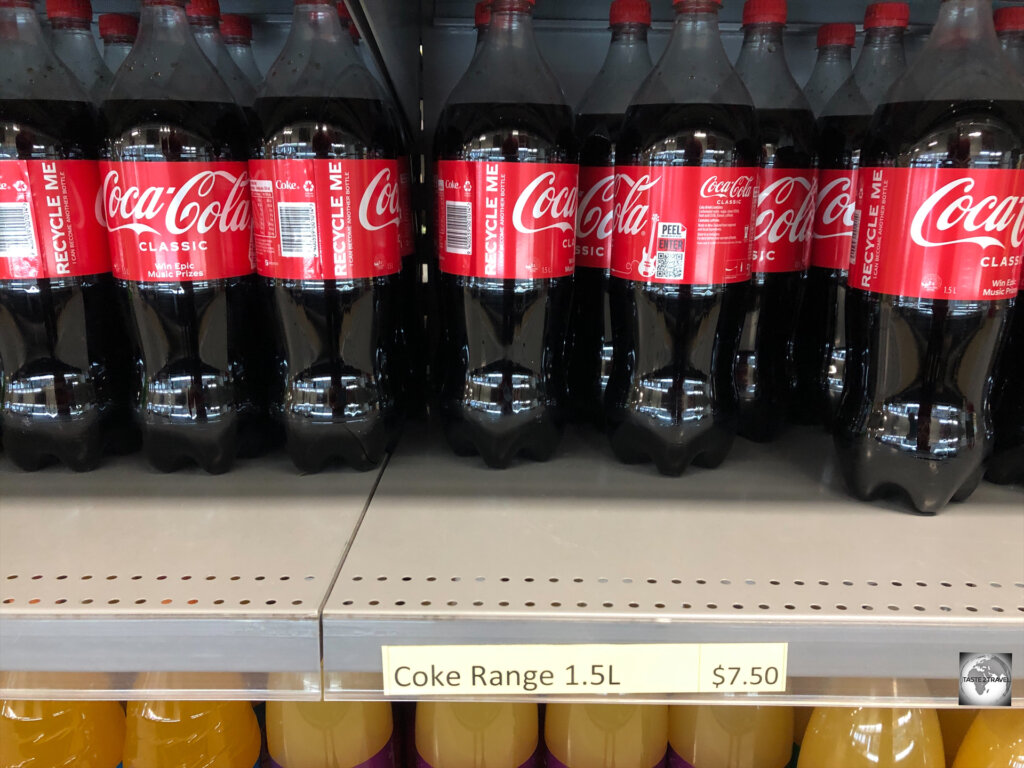
A 500-gram box of Corn Flakes costs XPF 1,100 (US$10.00) at the SEM Supermarket on Wallis.

A 500-gram box of Corn Flakes costs XPF 1,100 (US$10.00) at the SEM Supermarket on Wallis.

A typical return flight with Aircalin from Noumea to Wallis will cost around €700 (if you can book in one of the cheaper economy classes) while a return airfare between Wallis and Futuna Island costs XPF 29,800 (US$277.85).

The limited number of hotels offer rooms between XPF 12,000 (US$109) and XPF 18,000 (US$164).

An average meal price in one of the few restaurants costs between XPF 3,000 – 4,000 (US$27.00 – $36).

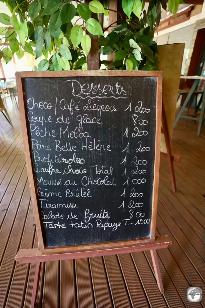
The dessert menu at Maloccino (XPF1,200 = US$10.88).

The dessert menu at Maloccino (XPF1,200 = US$10.88).

Other sample costs: 

  • Craft beer from Wallis Brewery (0.33 litre bottle): XPF 370 (US$3.38)
  • Box of Corn Flakes (500 grams): XCF 1,100 (US$10.00)
  • Car hire (per day) from Lausikula Chambre d’Hôtes: XCF 8,000 (US$72.98)
  • Litre of fuel: XPF 200 (US$1.82)
  • Hamburger and Chips meal at Angélus Garden: XPF 1,500 (US$13.60)
  • Grilled Fish meal at Beach Club: XCF 3,000 (US$27.37)
  • SIM card from the post office: XPF 5,000 (US$45.32)

SEM Supermarket

SEM Supermarket is the largest supermarket on Wallis Island.

SEM Supermarket is the largest supermarket on Wallis Island.

There are few shopping opportunities on Wallis and Futuna.

The largest supermarket in the territory is the SEM supermarket where most produce is imported from France.

A view of SEM Supermarket, the largest on Wallis Island.

A view of SEM Supermarket, the largest on Wallis Island.

Attached to the supermarket is a small shopping arcade where you’ll find the only branch of the Bank of Wallis and Futuna, the Aircalin office, the only museum on Wallis and Futuna, a bakery and several boutiques.

Business Opening Hours

As is typical in the Francophone world, all businesses on Wallis and Futuna, including SEM, close from 12:30 to 14:30 every day for lunch.

Most businesses close at lunchtime on Saturday and remain closed until Monday morning.

Almost nothing is open on Sunday!

Aquatic Sports

Small sail boats available for rent from Vaka Lä.

Small sail boats available for rent from Vaka Lä.

The turquoise waters of the lagoon which surrounds Wallis Island are inviting and there is no better way to get onto the water than by renting some aquatic equipment from Vaka Lä.

Just some of the equipment available to rent from Vaka Lä.

Just some of the equipment available to rent from Vaka Lä.

Located on the waterfront, 300 metres north of the Beach Club restaurant, Vaka Lä rents all sorts of aquatic equipment from surf boards, kayaks, small catamarans, sail boats and much more.

Located on the waterfront, Vaka Lä rents all sorts of aquatic equipment.

Located on the waterfront, Vaka Lä rents all sorts of aquatic equipment.

Vaka Lä Contacts:

A catamaran rental from Vaka Lä will allow you to explore the lagoon which surrounds Wallis Island.

A catamaran rental from Vaka Lä will allow you to explore the lagoon which surrounds Wallis Island.

Sightseeing
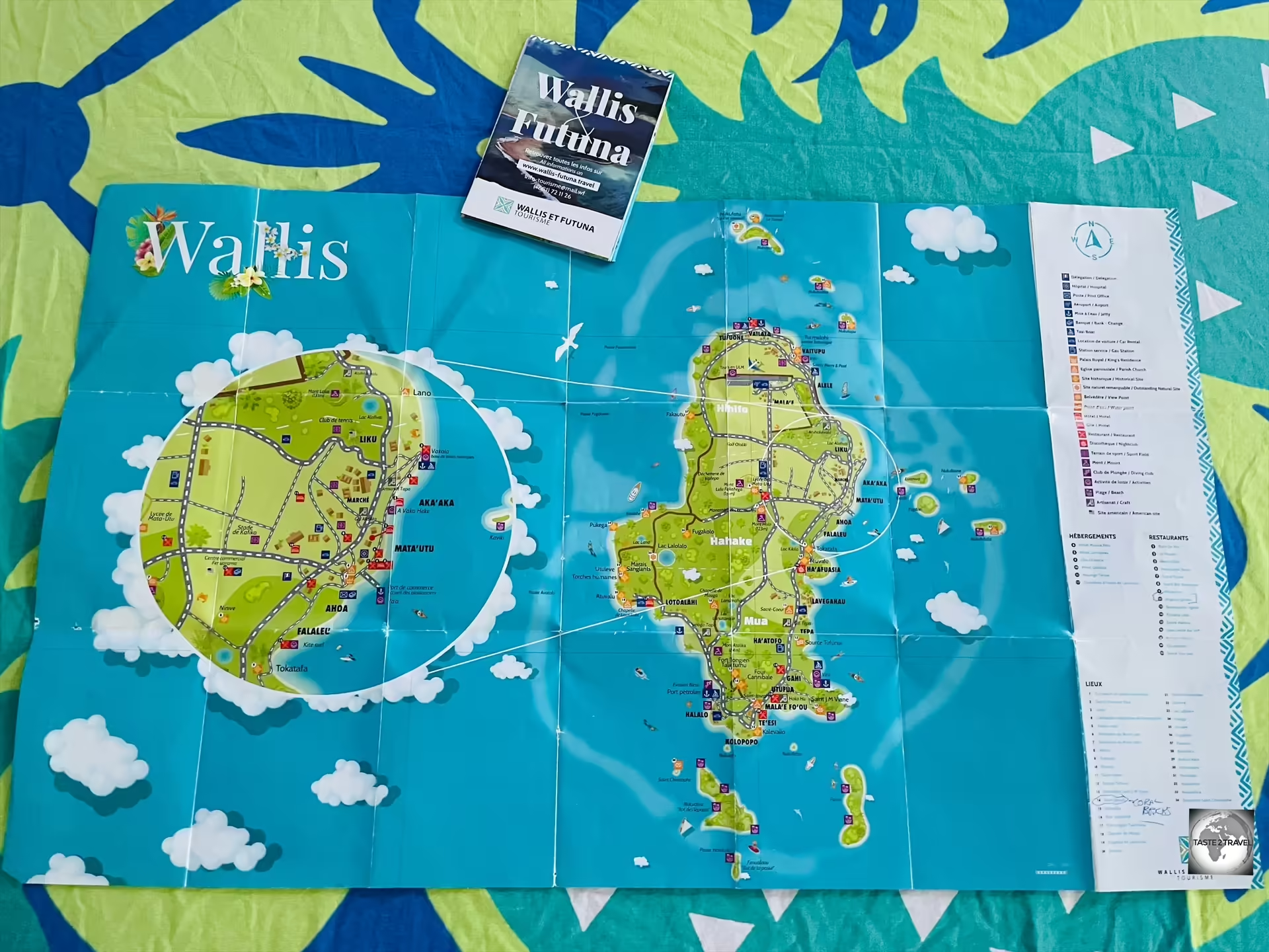
This newly published map of Wallis Island is indispensable while exploring the island.

This newly published map of Wallis Island is indispensable while exploring the island.

Wallis Island

Wallis Island’s blend of natural wonders, historical sites, and cultural experiences makes it a captivating destination for travellers seeking both relaxation and adventure.

Talietumu Fortress
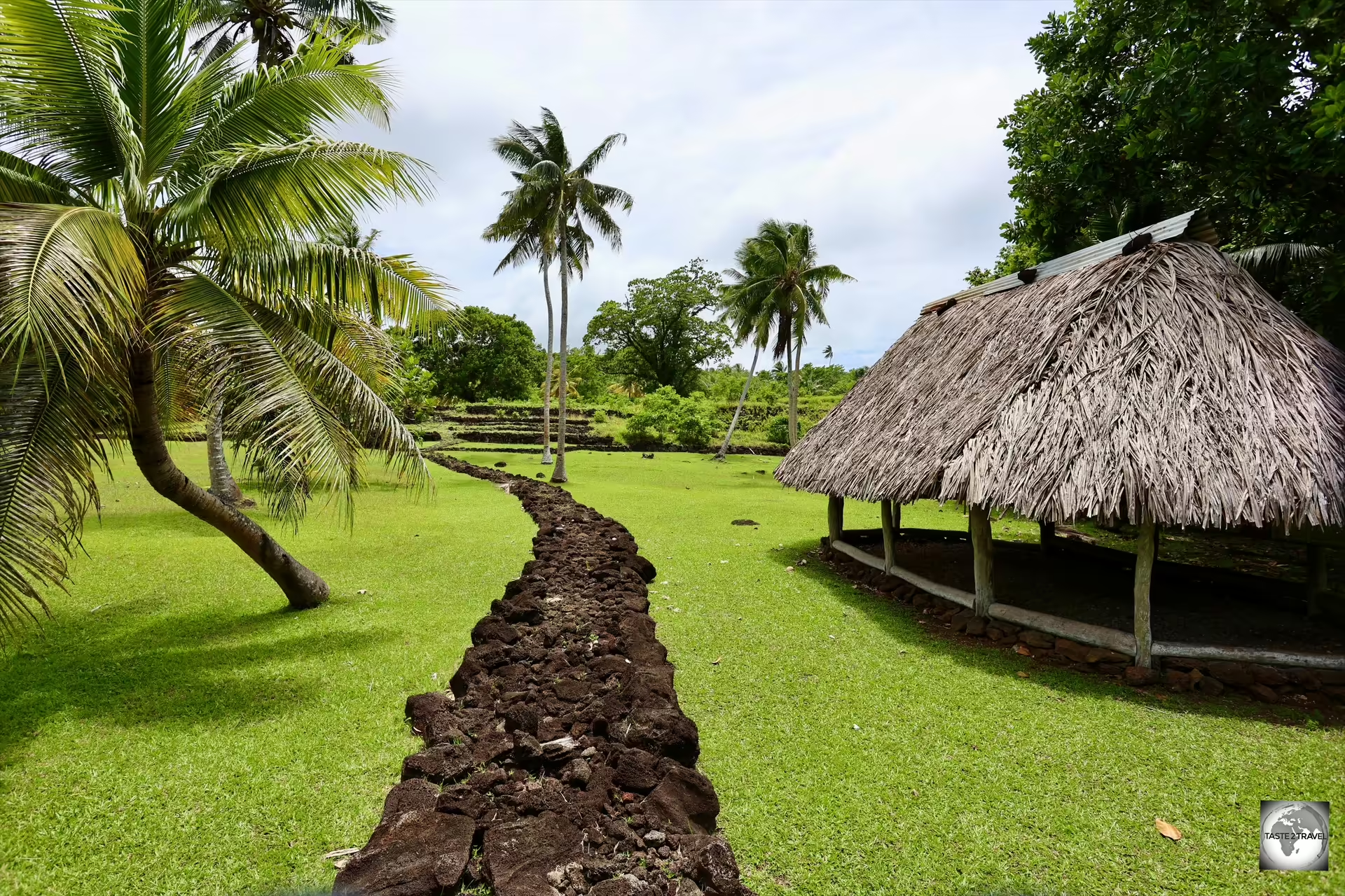
Talietumu is an ancient Tongan fort on Wallis Island.

Talietumu is an ancient Tongan fort on Wallis Island.

Surrounded by lush, tropical vegetation, the ruins of Talietumu Fortress are a highlight of Wallis Island.

Ruins of one of many ancient structures at <i>Talietumu</i>, a former Tongan fort on Wallis Island.

Ruins of one of many ancient structures at Talietumu, a former Tongan fort on Wallis Island.

Dating from the 1450s, and known to the Tongans as Kolo Nui, this former Tongan fortress is enclosed by a large basalt-stone wall and includes well-preserved, basalt-stone, ruins.

Dating from the 1450s, the ancient Tongan fortress of Talietumu was the last holdout of the Tongans on Uvea.

Dating from the 1450s, the ancient Tongan fortress of Talietumu was the last holdout of the Tongans on Uvea.

The fort is located about 9 km (5.6 mi) southwest of Mata-Utu, northeast of the village of Halalo, and is accessed from a (signposted) side road which leads onto a gravel access track.

A stone circle, with the supporting walls of the man-made platform in the background, at the Tongan fort.

A stone circle, with the supporting walls of the man-made platform in the background, at the Tongan fort.

The fort was built on the site of a boundary tri-point, between three ancient kingdoms, which once divided Wallis Island during the Tongan period.

Access to the Tongan fort is through a break in the wall near the car park.

Access to the Tongan fort is through a break in the wall near the car park.

Access into the enclosure is through a break in the wall, near the car park. The site is dominated by a raised, man-made, stone platform called Talietumu, which served as a Marae, i.e. a sacred place.

A view of the man-made stone platform, known as <i>Talietumu.</i>

A view of the man-made stone platform, known as Talietumu.

The large trees which provide shade on the upper platform are covered in wild orchid plants. Unfortunately, no orchids were flowering at the time of my visit.

From the main platform, a couple of steps leads to an upper platform which is completely covered by thick grass.

From the main platform, a couple of steps leads to an upper platform which is completely covered by thick grass.

From the main platform, a short flight of steps leads up to a higher platform which is completely covered in grass.
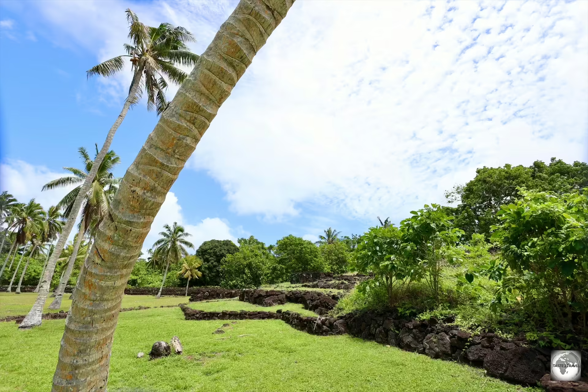
A view of the supporting walls, which support the man-made stone platform at the Tongan fort complex.

A view of the supporting walls, which support the man-made stone platform at the Tongan fort complex.

I visited the site twice and each time I was the only visitor.

Ruins of a former structure at the Tongan fort.

Ruins of a former structure at the Tongan fort.

Much of the outer areas of the site remain untouched, buried beneath lush vegetation.

A stone wall disappears beneath dense forest vegetation.

A stone wall disappears beneath dense forest vegetation.

Untouched, and devoid of visitors, there is a special energy which can be felt here.

The Tongan fort is an interesting place to visit and should be a candidate site for the UNESCO World Heritage list.

Lake Lalolalo

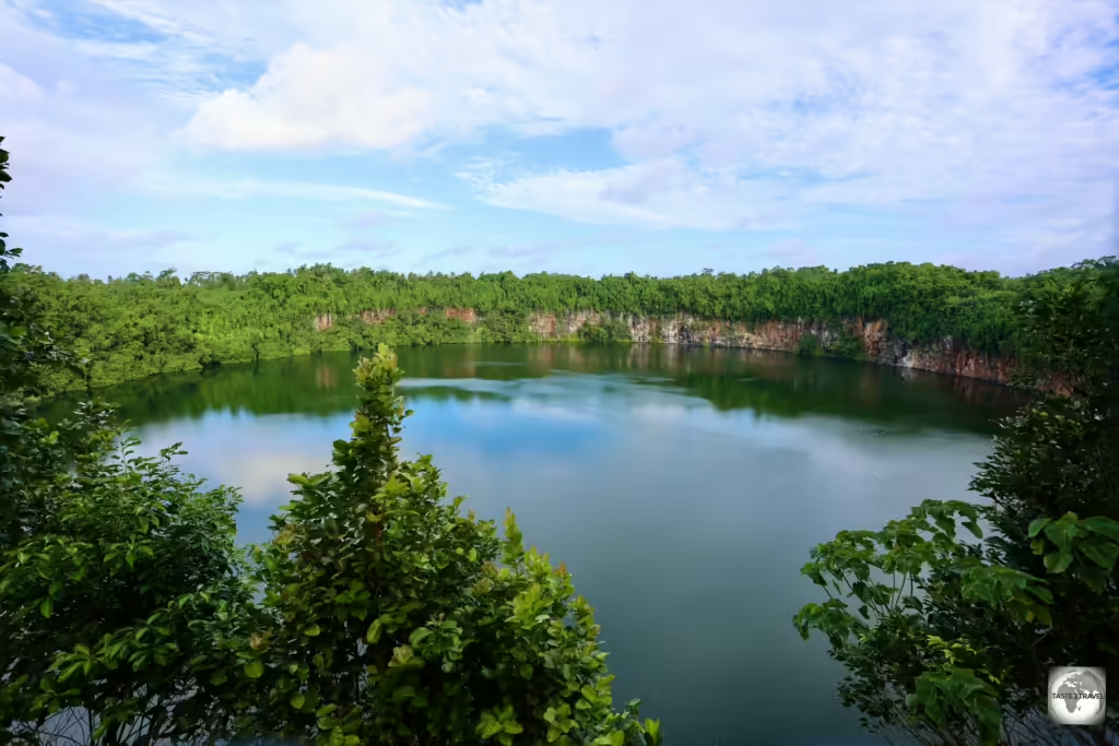
Dramatic and eerie, Lake Lalolalo is the largest of several, perfectly round craters lakes which can be found on this former volcanic island.

Dramatic and eerie, Lake Lalolalo is the largest of several, perfectly round craters lakes which can be found on this former volcanic island.

Lake Lalolalo is the largest of several craters lakes which can be found on the once volcanic Wallis Island.

This perfectly round, isolated, and somewhat eerie lake, is surrounded by lush, tropical jungle with a protective wall of sheer, 30m (98ft) high, cliffs which plunge into the murky depths ensuring no one can get too close.

Reaching a depth of 80-metres (262 feet), scuba divers have found a 2-km long underwater tunnel which runs to the west of the lake. Where the tunnel leads no one is certain with further exploration required.

Lake Lalolalo is completely surrounded by sheer red cliffs.

Lake Lalolalo is completely surrounded by sheer red cliffs.

Protected by its all-encompassing cliffs, the lake is a magnet for birds with flying foxes, terns, brown noddies and other birds constantly wheeling overhead.

At the end of World War II, the U.S. military dumped surplus equipment into the lake.

The lake is located north of Lausikula village along a gravel section of route RT1. A sign posted view point for the lake is located on the right-hand side of the road.

Lake Lanutavake

The emerald-green, Lake Lanutavake is the 2nd largest crater lake on Wallis Island.

The emerald-green, Lake Lanutavake is the 2nd largest crater lake on Wallis Island.

At about half the diameter of Lake Lalolalo, Lake Lanutavake is the 2nd largest crater lake on Wallis Island.

Located northeast of Fineveke village, this emerald-green, 24-metre-deep (78 ft), fresh water lake is completely surrounded by lush vegetation.

While there is no view point, you can easily photograph the lake from the road.

Like Lake Lalolalo, it is rumoured that the US military dumped equipment in the lake at the end of World War II.

Churches

The calm and peaceful, Chapel of Saint John the Baptist, is located in the east coast village of Falaleu.

The calm and peaceful, Chapel of Saint John the Baptist, is located in the east coast village of Falaleu.

As you drive around Wallis and Futuna, it’s hard not to notice the many spectacular churches which can be found in every village on the islands.

The French introduced religion to the islands with the first missionaries arriving in 1837. By 1842, Wallis had completely adopted Catholicism, and by 1846, Futuna followed suit.

Each village in the territory is dominated by an imposing, solid, towering church, most of which have been built from black basalt stone with white limestone mortar.

While Wallisian houses are generally, single-level, modest structures, the churches by contrast are multi-level design extravaganzas with each community seeming to compete with the next for the funkiest church design.

Almost all of the population are practicing Roman Catholics and the presence of the church is felt in every aspect of life. Many Wallisians start each day by attending a 5 a.m. morning mass.

The church plays a central role in education, health care, community activities, social services, and in politics.

Cathedral of Our Lady of the Assumption

The Cathedral of Our Lady of the Assumption in Mata-Utu.

The Cathedral of Our Lady of the Assumption in Mata-Utu.

Sitting alongside the Royal Palace in Mata-Utu, construction work on the Cathedral of Our Lady of the Assumption lasted from 1952 to 1959.

A view of the interior of the Cathedral of Our Lady of the Assumption in Mata-Utu.

A view of the interior of the Cathedral of Our Lady of the Assumption in Mata-Utu.

The church features two towers, with a clock installed in the right-hand tower. Between the towers, the royal insignia of Wallis, a Maltese cross, is installed.

Church of the Sacred Heart

The Church of the Sacred Heart is located in the village of Tepa.

The Church of the Sacred Heart is located in the village of Tepa.


Detail of the basalt-stone brickwork with white limestone mortar at the Church of the Sacred Heart.

Detail of the basalt-stone brickwork with white limestone mortar at the Church of the Sacred Heart.


Detail of one of the doorways at the Church of the Sacred Heart.

Detail of one of the doorways at the Church of the Sacred Heart.


Cemetery at the Church of the Sacred Heart.

Cemetery at the Church of the Sacred Heart.


A statue of Jesus, inside the Church of the Sacred Heart, is bedecked in many colourful <i>leis.

A statue of Jesus, inside the Church of the Sacred Heart, is bedecked in many colourful leis.

Over the centuries, the Wallisians have combined Catholic and Polynesian religious beliefs, including dressing Jesus, and the saints, in traditional leis.

Saint Joseph’s Church

A view of Saint Joseph's Church which dominates the southern village of Mala'efo'ou.

A view of Saint Joseph’s Church which dominates the southern village of Mala’efo’ou.

The very first place of Christian worship in Wallis dates back to 1840 and was dedicated to St. Joseph.

A view of the interior of Saint Joseph's Church.

A view of the interior of Saint Joseph’s Church.

Eager to have their own stone church, parishioners spent 10 years constructing a beautiful house of worship which overlooks the south coast of Wallis in the village of Mala’efo’ou.
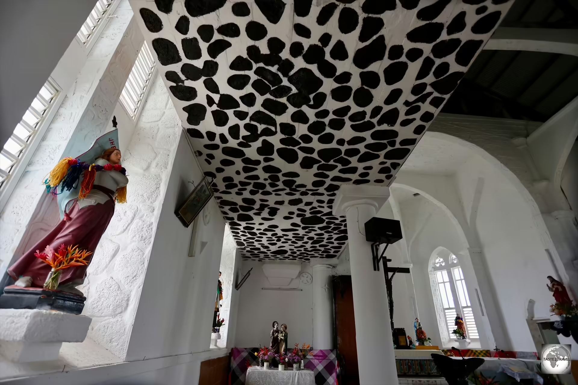
A view of the interior of Saint Joseph's Church.

A view of the interior of Saint Joseph’s Church.

Saint Joseph’s Church was opened in 1869.

Chapel of Saint Bernadette

A view of the enormous interior of the Chapel of Saint Bernadette, Lausikula.

A view of the enormous interior of the Chapel of Saint Bernadette, Lausikula.

A recent addition to the collection of churches on Wallis, the totally oversized Chapel of Saint Bernadette was built following the destruction of the original, smaller, chapel during cyclone Evan which hit the island in December of 2012.

Described as totally ostentatious, the oversized Chapel of Saint Bernadette overlooks the coast in the tiny village of Lausikula.

Described as totally ostentatious, the oversized Chapel of Saint Bernadette overlooks the coast in the tiny village of Lausikula.

The chapel overlooks the south-west coast in the tiny settlement of Lausikula.

This overbearing edifice was built at the urging of the local parish priest and consecrated in 2014.

Church of Saints Peter and Paul

The Church of Saints Peter and Paul overlooks the sea in the east coast village of Vaitupu.

The Church of Saints Peter and Paul overlooks the sea in the east coast village of Vaitupu.

Looking more like a Chinese pagoda, the Church of Saints Peter and Paul overlooks the sea in the sleepy east coast village of Vaitupu.

Traditional Wallisian artwork inside the Church of Saints Peter and Paul.

Traditional Wallisian artwork inside the Church of Saints Peter and Paul.

The Hihifo parish church was initially built in the village of Vailila and later transported to its current location in Vaitupu in October 1848.

Construction work of the present church lasted from 1865 to 1866.

Chapel of Saint Joan of Arc
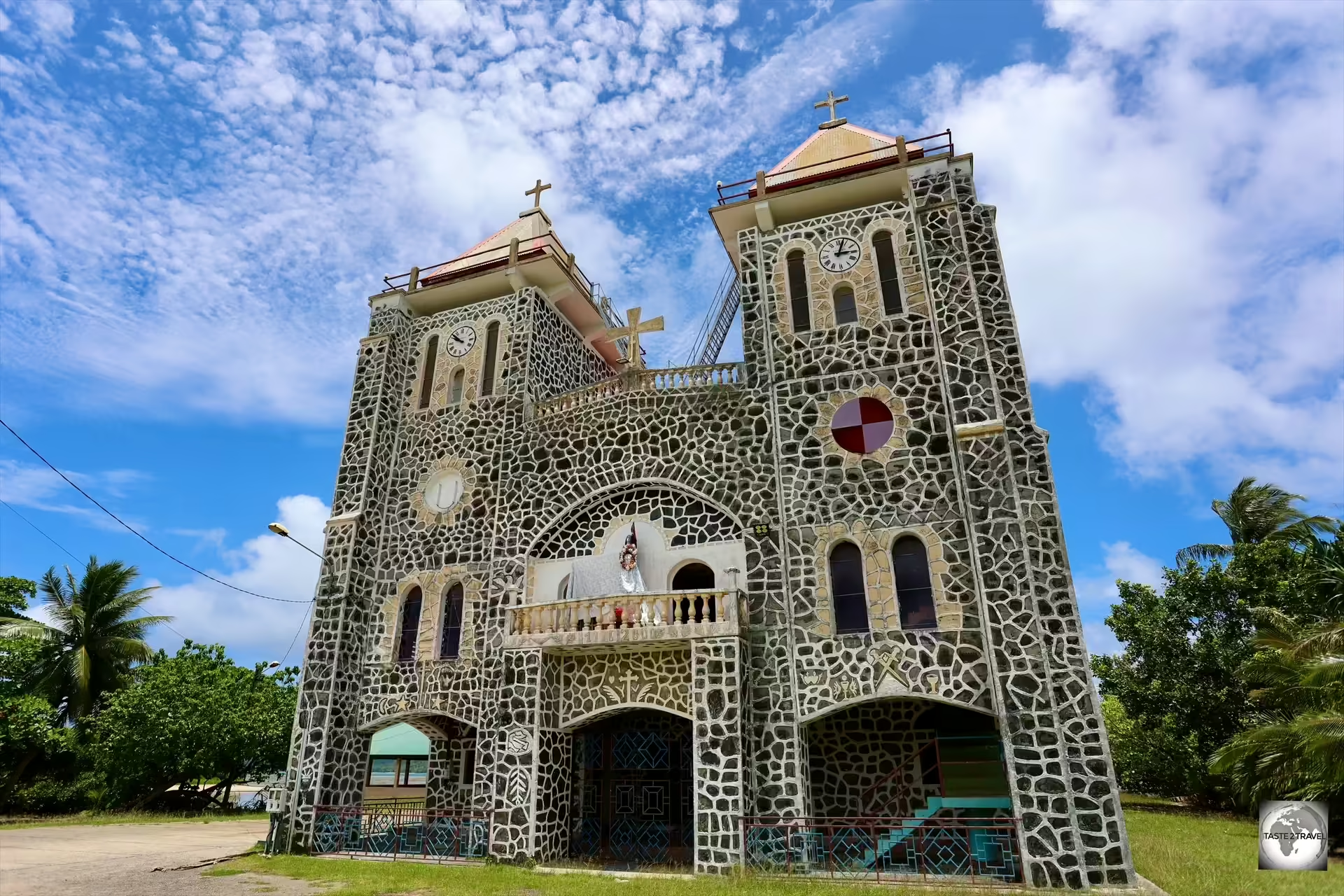
A view of the Chapel of Saint Joan of Arc, Halalo village.

A view of the Chapel of Saint Joan of Arc, Halalo village.

Dominating the tiny south coast village of Halalo, the Chapel of Saint Joan of Arc features a striking interior with the ceiling lined with panels featuring traditional Polynesian designs.

A view of the interior of the Chapel of Saint Joan of Arc, Halalo village.

A view of the interior of the Chapel of Saint Joan of Arc, Halalo village.


Always seen holding a white flag, St. Joan of Arc, the patroness of soldiers and of France, dressed in a traditional <i>lei.

Always seen holding a white flag, St. Joan of Arc, the patroness of soldiers and of France, dressed in a traditional lei.

Wallis Museum

The single-room Wallis Museum is located inside the shopping arcade behind the SEM Supermarket.

The single-room Wallis Museum is located inside the shopping arcade behind the SEM Supermarket.

The only museum on Wallis and Futuna, the one-room Wallis Museum is located inside the shopping arcade behind the SEM Supermarket.

The museum, which is always closed, can be visited by contacting Christophe Laurent at Wallis Voyages in Mata-Utu.

Christophe normally conducts tours every Thursday afternoon after he finishes work at the travel agency.

Contact details for Christophe:

Entrance fee for the museum is XPF 1,000. 

Futuna Island

Flying from Wallis Island to Futuna Island.

Flying from Wallis Island to Futuna Island.

Located 260 km (160 mi) south-west of Wallis Island (halfway between Wallis and Fiji), Futuna Island, and the (almost) uninhabited Alofi Island, form the Hoorn Islands.

This remote archipelago was named by the Dutch navigators Willem Schouten and Jacob Le Maire, who, in 1616, became the first Europeans to visit the islands.

They named it after the Dutch city of Hoorn, from which their expedition had started.

The Hoorn Islands are separated from Wallis Island to the north by the Vitiaz Trench, which reaches a depth of 4,500 metres (14,763 ft).
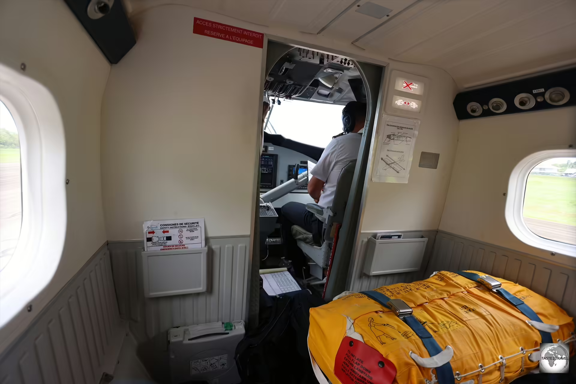
The first row of seats on the Wallis to Futuna flight have been replaced by a life raft, in case the plane has to ditch at sea.

The first row of seats on the Wallis to Futuna flight have been replaced by a life raft, in case the plane has to ditch at sea.

It’s a good thing that the small twin prop plane which connects the two islands has a full-size life raft installed in the first row of the cabin.

In terms of size, at 83 km2 (32 sq mi) in area, Futuna is slightly smaller than Wallis which is 100 km2 (39 sq mi).

A view of the populated, narrow coastal strip and the uninhabited, mountainous, interior of Futuna.

A view of the populated, narrow coastal strip and the uninhabited, mountainous, interior of Futuna.

Unlike Wallis, the interior of Futuna is almost vertical and totally uninhabited. Covered in lush tropical jungle, it is the domain of nesting sea birds such as tern’s, brown noddy’s, frigate and tropic birds.

The highest point on Futuna is Mont Puke, which is 524 metres (1,719 ft) above sea level.

Much of the vegetation on Futuna Island is covered by Mikania micrantha, an invasive and pervasive vine which was deliberately introduced by the U.S. Military during WWII.

Much of the vegetation on Futuna Island is covered by Mikania micrantha, an invasive and pervasive vine which was deliberately introduced by the U.S. Military during WWII.

Much of the vegetation on Futuna is covered by a dense canopy of Mikania micrantha, an invasive and pervasive vine which was deliberately (and recklessly) introduced to both Futuna and Wallis by the U.S. Military during WWII as a form of camouflage for their equipment.

Today, the vine is out of control!

The capital of Futuna is the tiny settlement of Leava.

The capital of Futuna is the tiny settlement of Leava.

The population of Futuna is 3,225 with everyone living along the narrow coastal strip.

The capital of Futuna is the tiny settlement of Leava.

Leava chapel serves the small community of Leava, the capital of Futuna Island.

Leava chapel serves the small community of Leava, the capital of Futuna Island.

Opposite Leava chapel, lies a memorial to Saint Pierre Chanel, who was a Catholic priest, missionary, and martyr.

A memorial to St. Pierre Chanel, a Catholic priest, missionary, and martyr.

A memorial to St. Pierre Chanel, a Catholic priest, missionary, and martyr.

Chanel arrived on Futuna in November 1837 and was clubbed to death in April 1841 at the instigation of a chief upset because his son converted to Catholicism.

Church of Saint Joseph 

A view of the Church of Saint Joseph which dominates the village of Nuku.

A view of the Church of Saint Joseph which dominates the village of Nuku.

Located in the coastal village of Nuku, in the constituency of Sigave, the Church of Saint Joseph is where the king of Sigave attends mass.

The royal throne, which is used by the King of Sigave whenever he attends service at St. Joseph's church in Nuku.

The royal throne, which is used by the King of Sigave whenever he attends service at St. Joseph’s church in Nuku.

The king’s ornate, wooden throne can be seen in the front row of the church.

A view of the interior of the Church of Saint Joseph, Nuku.

A view of the interior of the Church of Saint Joseph, Nuku.

The King of Sigave (titled as Tu`i Sigave) is the ruler of the polity of Sigave, one of the two chiefdoms located on Futuna.

Sigave encompasses the western part of the island.

Mary and Jesus, both wearing <i>leis</i>, on the altar of St. Joseph's church.

Mary and Jesus, both wearing leis, on the altar of St. Joseph’s church.

At the altar, both Mary and Jesus can be seen, adorned in traditional leis.

One of the many <i>fale fono</i> - traditional meeting houses - on Futuna Island.

One of the many fale fono – traditional meeting houses – on Futuna Island.

While there are many churches on Futuna, there are even more ‘fale fono‘ – traditional meeting houses, a place where elders gather to discuss matters of importance, much like their forebears did.

A view of a traditional meeting house.

A view of a traditional meeting house.

Accommodation

Wallis Island

There are very few accommodation options on Wallis Island and most of the properties cannot be booked online nor do they respond to email enquiries, or answer the telephone, which makes it very difficult to book a room.

The best option is to book one of the two Airbnb properties, which allows you to book online, pay in advance and to communicate with your host online.

There are four accommodation options on Wallis Island and two on Futuna Island. All are covered in this section.

Lausikula Chambre d’Hôtes

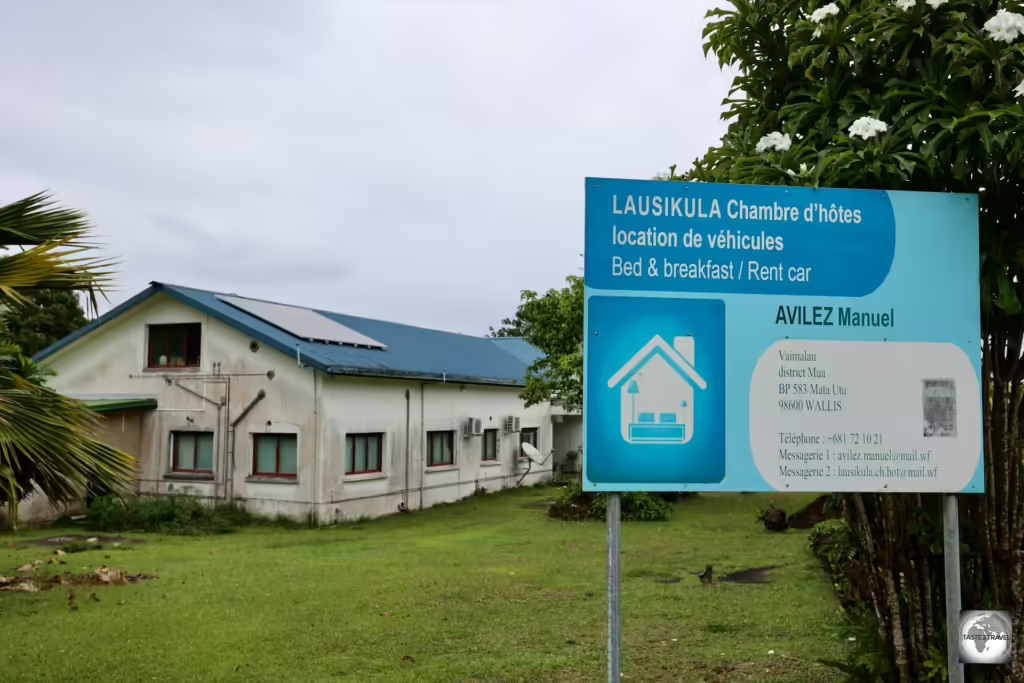
Lausikula Chambre d'Hôtes, my homestay on Wallis Island, which I booked online via Airbnb.

Lausikula Chambre d’Hôtes, my homestay on Wallis Island, which I booked online via Airbnb.

Using Airbnb, I booked a room in Lausikula Chambre d’Hôtes – a family run guesthouse which is located in the seaside village of Lausikula, on the remote south-west coast of Wallis Island.

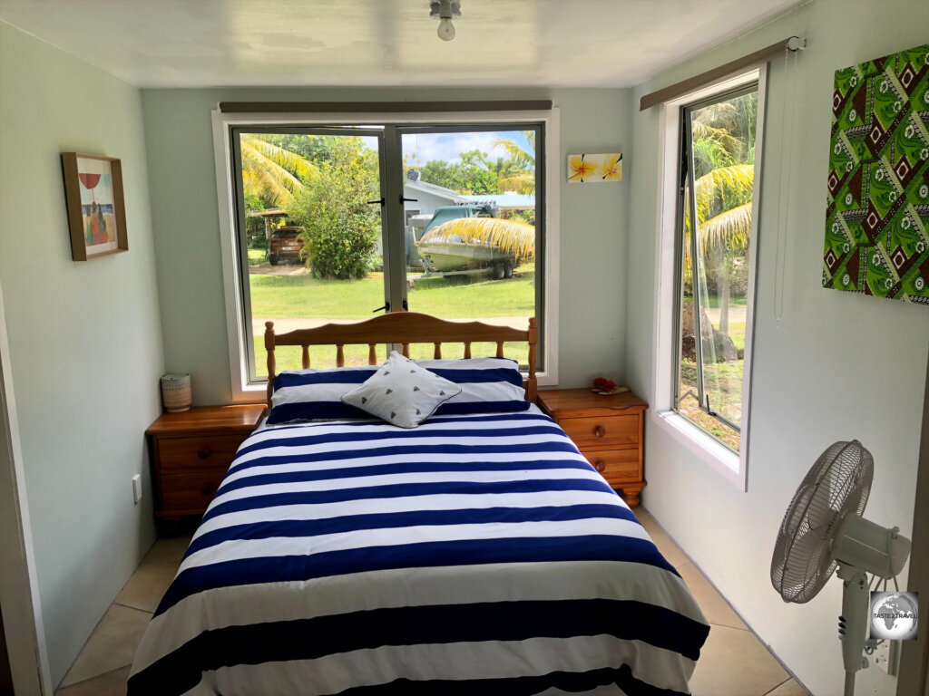
My room at Lausikula Chambre d'Hôtes on Wallis Island.

My room at Lausikula Chambre d’Hôtes on Wallis Island.

Rooms

Operated by Manuel Avilez, a Spanish/ French expat who has lived on Wallis Island since 2003, the guesthouse consists of 4 large rooms, all with private bathrooms.

My spacious bathroom at Lausikula Chambre d'Hôtes.

My spacious bathroom at Lausikula Chambre d’Hôtes.

Although the rooms are old and tired, they are spacious and comfortable and cost XPF 12,000 (US$109) per night.

Meals

Breakfast, served by Manuel at <i>Lausikula Chambre d'Hôtes</i>, included Wallis Island honey - some of the purest honey in the world.

Breakfast, served by Manuel at Lausikula Chambre d’Hôtes, included Wallis Island honey – some of the purest honey in the world.

  • Breakfast, which consists of fresh baguettes, jam and local honey (truly delicious!) is included in the room rate.
  • Dinner, which is always a 2-course (main and dessert) gourmet affair costs XPF 4,000 (US$36.37).

I highly recommend the dinners served by Manuel, which were comparable to meals served in the two best restaurants in town.

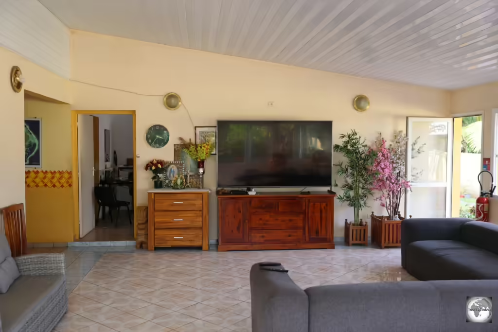
The living room at Lausikula Chambre d'Hôtes on Wallis Island.

The living room at Lausikula Chambre d’Hôtes on Wallis Island.

If you wish to eat out, the only restaurants are in Mata’Utu, which is a 20-minute drive.

It should be noted that at night, there is no street lighting on Wallis and no street signs anywhere! If venturing out, you must be confident with the directions back to the guesthouse!

Self-Catering

Manuel has no problem with guests using his fully equipped kitchen, which allows guests to self-cater.

Airport Transfers

Manuel offers airport transfers at XPF 1000 (US$9.00) which is totally reasonable considering the airport is at the opposite end of the island from his guesthouse.

Rental Cars

I rented this Toyota Hilux from Manuel for XPF 8,000 per day.

I rented this Toyota Hilux from Manuel for XPF 8,000 per day.

Due to the remote location of the guesthouse, you will need to hire a rental car.

Manuel offers several manual cars (not in the best condition but perfectly drivable) for XPF 8,000 (US$72.74) per day.

Fuel on the island costs XPF 200 (US$1.82) per litre.

A half tank of fuel at the end of my week-long stay cost XPF 9,000 (US$81.84).

Contact details for Manuel: 

The best way to contact Manuel is by WhatsApp messenger.

Hotel Lomipeau

Rooms at the Hotel Lomipeau overlook the swimming pool - the only pool on the island.

Rooms at the Hotel Lomipeau overlook the swimming pool – the only pool on the island.

Despite being the principal hotel on Wallis Island, you should not expect any response to any accommodation enquiries from the (seemingly) invisible staff at Hotel Lomipeau.

When I was first planning my trip to Wallis, I tried to contact the hotel using email, telephone and even Instagram message. I never received any response from the hotel.

The view of Wallis Island from the terrace of the Hotel Lomipeau.

The view of Wallis Island from the terrace of the Hotel Lomipeau.

When I was on the island, I visited the hotel, which is located in the heart of Mata-Utu, and found no one in attendance.

The reception door was open, but the lights were off and there were no staff to be found anywhere. I was assured by locals that the hotel is open and functioning.

Hotel Lomipeau is located in the heart of Mata-Utu, the capital of Wallis Island.

Hotel Lomipeau is located in the heart of Mata-Utu, the capital of Wallis Island.

Rooms 

If you can manage to make a reservation, the hotel offers 10 rooms with room rates being:

  • Single Room: XPF 18,000 (US$164)
  • Double Room: XPF 21,000 (US$191)
  • Twin Room: XPF 21,000 (US$191)

Room rates include breakfast!

The hotel boasts the only swimming pool on the island.

Hotel Lomipeau Contact Details: 

Hotel Moana Hou

Located on the waterfront, Hotel Moana Hou offers a variety of rooms.

Located on the waterfront, Hotel Moana Hou offers a variety of rooms.

Located directly on the waterfront, below the Hotel Lomipeau, the Hotel Moana Hou offers 22 rooms, 7 studios and 3 bungalows.

Artwork, on the wall of the restaurant at the Hotel Moana Hou.

Artwork, on the wall of the restaurant at the Hotel Moana Hou.

The hotel is located 400 metres from Beach Club (see the ‘Eating Out‘ section below) and 1.5 km from Mata-Utu Cathedral and the Royal Palace.

Room Rates

Room rates at the Hotel Moana Hou are:

  • Single room: XPF 12,500 (US$113.66)
  • Double room: XPF 15,500 (US$140.94)
  • Family room: XPF 15,500 (US$140.94)
  • Suite: XPF 20,000 (US$181.86)

Meals

The restaurant at Hotel Moana Hou on Wallis Island.

The restaurant at Hotel Moana Hou on Wallis Island.

Hotel Moana Hou offers a restaurant service with breakfast included in the nightly rate.

Lunch and dinner are also available.

Hotel Moana Hou Contact Details: 

Manager: Madame Malia Kulikovi
Telephone: (+681) 72 21 35
Email: moana-hou@mail.wf
Facebook: Hôtel Moana Hou

Hotel Ulukula

Located a short walk inland from Mata-Utu, Hotel Ulukula offers 26 rooms.

Located a short walk inland from Mata-Utu, Hotel Ulukula offers 26 rooms.

Located a short distance inland from Mata-Utu, Hotel Ulukula resembles a roadside motel with guests parking their rental cars outside their rooms.

The reception area at Hotel Ulukula on Wallis Island.

The reception area at Hotel Ulukula on Wallis Island.

This is a clean and functional property which is centrally located.

Rooms

Hotel Ulukula offers 21 rooms plus 5 studio apartments.

Nightly room rates, which include breakfast, are:

  • Studio/ room for 1 person: XPF 9,000 (US$81.84)
  • Studio/ room for 2 persons: XPF 13,000 (US$118.21)
  • Studio/ room for 3 persons: XPF 18,000 (US$163.67)
  • Studio/ room for 4 persons: XPF 19,000 (US$172.77)

Hotel Ulukula Contacts: 

Futuna Island

There are two accommodation options on Futuna Island and they can be fully booked. It’s best to check room availability before booking flights to Futuna.

Hotel FiaFia

Hotel FiaFia is one of two hotels on Futuna Island.

Hotel FiaFia is one of two hotels on Futuna Island.

Like everything on Futuna Island, Hotel Fiafia is located on the narrow coastal strip, in the village of Nuku, which is a five minutes’ drive from the island’s capital – Leava.

Rooms

A view of my room at Hotel FiaFia on Futuna Island.

A view of my room at Hotel FiaFia on Futuna Island.

The hotel offers 9 rooms which consist of 2 single rooms, 4 double rooms (with a balcony) and 3 suites.

At the time of my visit, the hotel was booked out by a team of visiting French marine biologists who were on the island conducting underwater surveys. As part of their job, they were paid to scuba dive each day in the waters surrounding this paradise island.

Rooms at Hotel FiaFia include a fridge, TV and microwave.

Rooms at Hotel FiaFia include a fridge, TV and microwave.

I was able to secure one of their double rooms for just one night.

A very average breakfast is included in the room rate. Breakfast consisted of jam and dried crackers (even though fresh baguettes are available on the island).

Rooms rates at Hotel Fiafia are:

  • Single room: XPF 9,000 (US$81.84)
  • Double room with balcony and a view of the sea: XPF 12,000 (US$109.12)
  • Suite: XPF 14,000 (US$127.30)

Airport Transfers

Hotel Fiafia offers airport transfers at XPF 3000 one way (US$27.00) which is expensive considering the airport is just 11km from the hotel.

Meals

With just one snack shop on Futuna, which operates on a very part time basis, most guests eat at the hotel restaurant, where a 2-course meal (main and dessert) costs XPF 3,500 (US$31.83).

The hotel offers a very good lunch and dinner at the same rate.

Hotel Fiafia Contacts:

  • Manager: Monsieur Tortey Patrick
  • Main Contact: Damien (the son of Tortey Patrick)
  • Telephone: (+681) 72 32 45
  • Email: hotel_fiafia@yahoo.fr

Hotel de Somalama Park

One other option on Futuna Island is the more distant Hotel de Somalama.

Located in the seaside village of Toloke, this family-run hotel offers 8 rooms.

Room Rates:

  • Single occupancy: XPF 9,000
  • Double occupancy: XPF 12,000
  • Triple occupancy: XPF 15,000
Meals 
Lunch and dinner are available at XPF 1,500 (US$13.64)

Hotel de Somalama Park Contacts: 

Eating Out

A perfect Tuna Tataki, served at Maloccino restaurant.

A perfect Tuna Tataki, served at Maloccino restaurant.

The cuisine of Wallis and Futuna combines French and local cooking traditions, with one of my favourite meals being local tuna tataki as a main course, finished with a Café gourmand for dessert.

A French classic dessert served with a local twist - a divine Café gourmand, with homemade mango ice cream, served at Beach Club.

A classic French dessert served with a local twist – a divine Café gourmand, with homemade mango ice cream, served at Beach Club.

Wallis Island

Apart from the excellent meals served by Manuel at my homestay on Wallis, there are a small number of restaurants on Wallis Island.

All restaurants are listed on the Eating Out page of the Wallis and Futuna Tourism website.

Maloccino

Located in the heart of Mata-Utu, Maloccino offers fantastic local and international cuisine.

Located in the heart of Mata-Utu, Maloccino offers fantastic local and international cuisine.

If I had to pick one favourite restaurant on Wallis, it would have to be Maloccino.

The restaurant offers a selection of local and international dishes with my favourite being the amazingly fresh Tuna tataki (pictured above).

Set in a garden, opposite the hospital, the menu at Maloccino features duck, beef, fish and much more.

The desserts are superb, with the creamy and smooth Mousse au Chocolat being a favourite.

Opening Hours:

  • Monday to Saturday: 8 a.m. to 3 p.m.
  • Friday and Saturday: 7 p.m. to 10 p.m.

Beach Club

Located directly on the waterfront, Beach Club offers a chilled ambiance with excellent food and drinks.

Located directly on the waterfront, Beach Club offers a chilled ambiance with excellent food and drinks.

Despite its name, there is no beach to be found at the Beach Club.

However, for both location and value, it’s hard to beat this seaside chill-out zone which is both a bar and restaurant.

The waterfront wooden dining deck at Beach Club is kept cool by a constant sea breeze.

The waterfront wooden dining deck at Beach Club is kept cool by a constant sea breeze.

The popular Beach Club is truly all things to all people, offering a chillout lounge, bar and restaurant, all of which is kept chilled by a constant sea breeze.

The view from the deck at Beach Club.

The view from the deck at Beach Club.

Apart from wonderful cuisine, Beach Club offers unbeatable views of the lagoon and some of the offshore islets.

One of the only bars on Wallis can be found at Beach Club.

One of the only bars on Wallis can be found at Beach Club.

The best value lunch on Wallis would have to be Beach Club’s excellent Salad buffet which offers unlimited salad, rice, pasta, charcuterie (cold cuts), shrimps and tuna tataki.
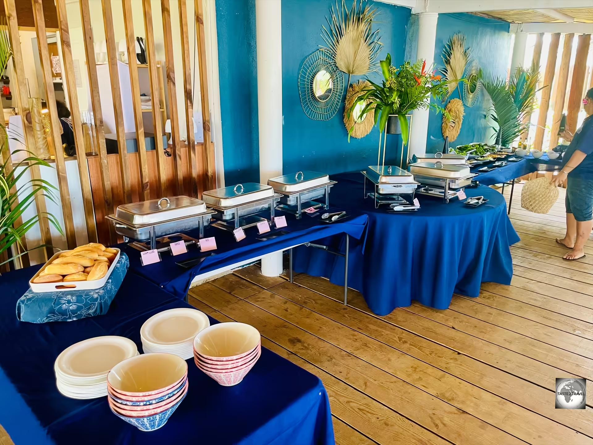
The best value lunch on Wallis - the Salad buffet at Beach Club.

The best value lunch on Wallis – the Salad buffet at Beach Club.

The buffet à volonté (all-you-can-eat) costs XPF 3,600 (US$32.63) which is a bargain when you consider a regular salad from the menu costs XPF 3,000.

Grilled local fish, mashed potato and homemade lemonade at Beach Club.

Grilled local fish, mashed potato and homemade lemonade at Beach Club.

Apart from the excellent value buffet lunch, regular menu items feature local produce with French influences.
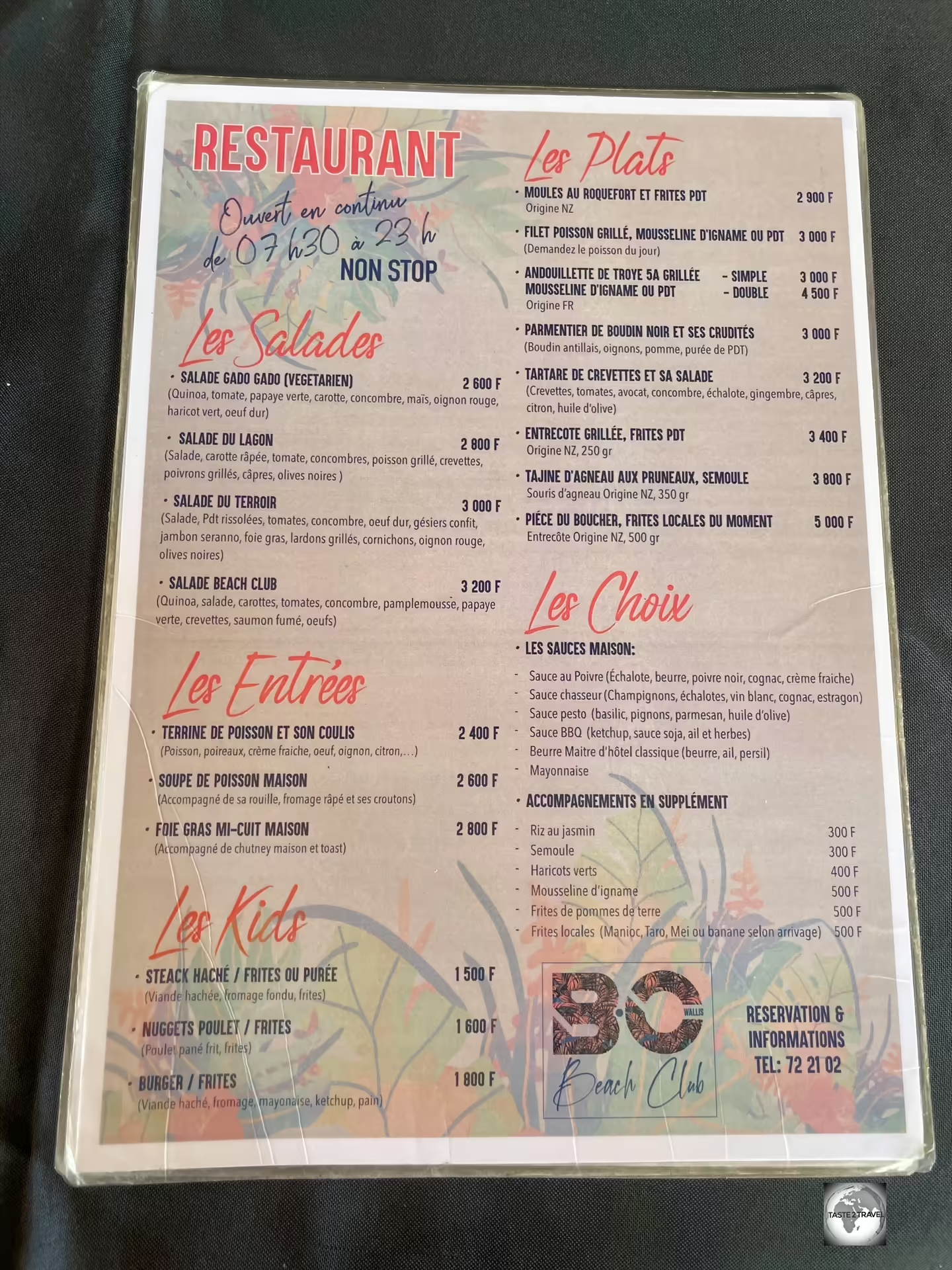
The food menu at Beach Club.

The food menu at Beach Club.

Located on the waterfront, Beach Club is open from breakfast to dinner from 7:30 a.m. to 11 p.m.

Angélus Garden

The restaurant at Angélus Garden.

The restaurant at Angélus Garden.

Located next to a roundabout in the interior of Wallis Island, Angélus Garden offers a menu of affordable, family favourites such as hamburgers and chips.

A classic hamburger with chips costs XPF 1,500 (US$13.60).

Located in the interior of Wallis Island, Angélus Garden is a popular restaurant with local families.

Located in the interior of Wallis Island, Angélus Garden is a popular restaurant with local families.

This is a popular restaurant with local families and, on each Sunday (the day of rest for all Wallisian’s), Angélus Garden offer a children’s playground complete with a bouncy castle.

Lausikula Chambre d’Hôtes

One of the many gourmet meals served by Manuel - a perfectly cooked steak <i>(à point)</i> with fresh garden salad and taro.

One of the many gourmet meals served by Manuel – a perfectly cooked steak (à point) with fresh garden salad and taro.

During my stay on Wallis Island, I ate most dinners at my accommodation – Lausikula Chambre d’Hôtes – where the owner, Manuel, offered 2-course dinners (main and dessert) for XPF 4,000 (US$36.37).

Manuel served food which was as good as anything offered in the local restaurants, without the need to drive anywhere.

A keen gardener, Manuel always included his fresh garden produce in the nighty meal.

Each evening, most guests chose to eat dinner at the guesthouse which was always finished with dessert and espresso coffee.

Futuna Island

On Futuna Island, your dining choices are limited to meals served at Hotel FiaFia or the nearby Snack Non-Stop.

Hotel FiaFia

Lunch at Hotel FiaFia - a perfectly cooked steak, served with taro chips and a beautiful fresh salad.

Lunch at Hotel FiaFia – a perfectly cooked steak, served with taro chips and a beautiful fresh salad.

The best meals on Futuna are served in the restaurant at Hotel FiaFia where a 2-course meal (main and dessert) costs XPF 3,500 (US$31.83).

The restaurant is open for lunch and dinner each day.

Snack Non-Stop 

Despite its name, Futuna's only eatery, "Snack Non-Stop", is closed more than it's open.

Despite its name, Futuna’s only eatery, “Snack Non-Stop”, is closed more than it’s open.

Despite its name, Snack Non-Stop is closed more than its open.

Located in the main settlement of Leava, this snack shop is a short walk from Hotel FiaFia.

The menu features sandwiches, paninis, fried chicken, local fish and more.

Wallis & Futuna Brewery

The spotlessly clean brew house at <i>Brasserie d'Uvea.</i>

The spotlessly clean brew house at Brasserie d’Uvea.

The brewing wizards at Brasserie d’Uvea have created some of the finest tasting craft beers I have ever had the pleasure to quaff – and I have sampled beers around the world!

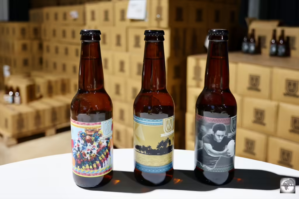
A degustation of the three types of delectable, bottled craft beers from the Wallis Island Brewery.

A degustation of the three types of delectable, bottled craft beers from the Wallis Island Brewery.

Using local water and ingredients, the brewery bottles three different craft beers:

  • Tokaleleï (right) – a very tasty Pale Ale (5.0% alc.)
  • Oseania (top left) – a refreshing wheat ale (5.0% alc.)
  • 1966 (bottom left) – a powerful Blonde Ale / Golden Ale (7.0% alc.)
The three different types of bottled beer offered by the Wallis Island Brewery.

The three different types of bottled beer offered by the Wallis Island Brewery.

Unfortunately for beer lovers, in order to sample these amazing beers, you will need to make the long trek to Wallis Island as the beer is not exported.

Wallis Island craft beer for sale at the SEM supermarket.

Wallis Island craft beer for sale at the SEM supermarket.

Currently the beer is only sold on the island, including in the SEM supermarket – the largest supermarket on Wallis Island, where a bottle of beer costs XPF 370 (US$3.34).

Brasserie Bar Nights
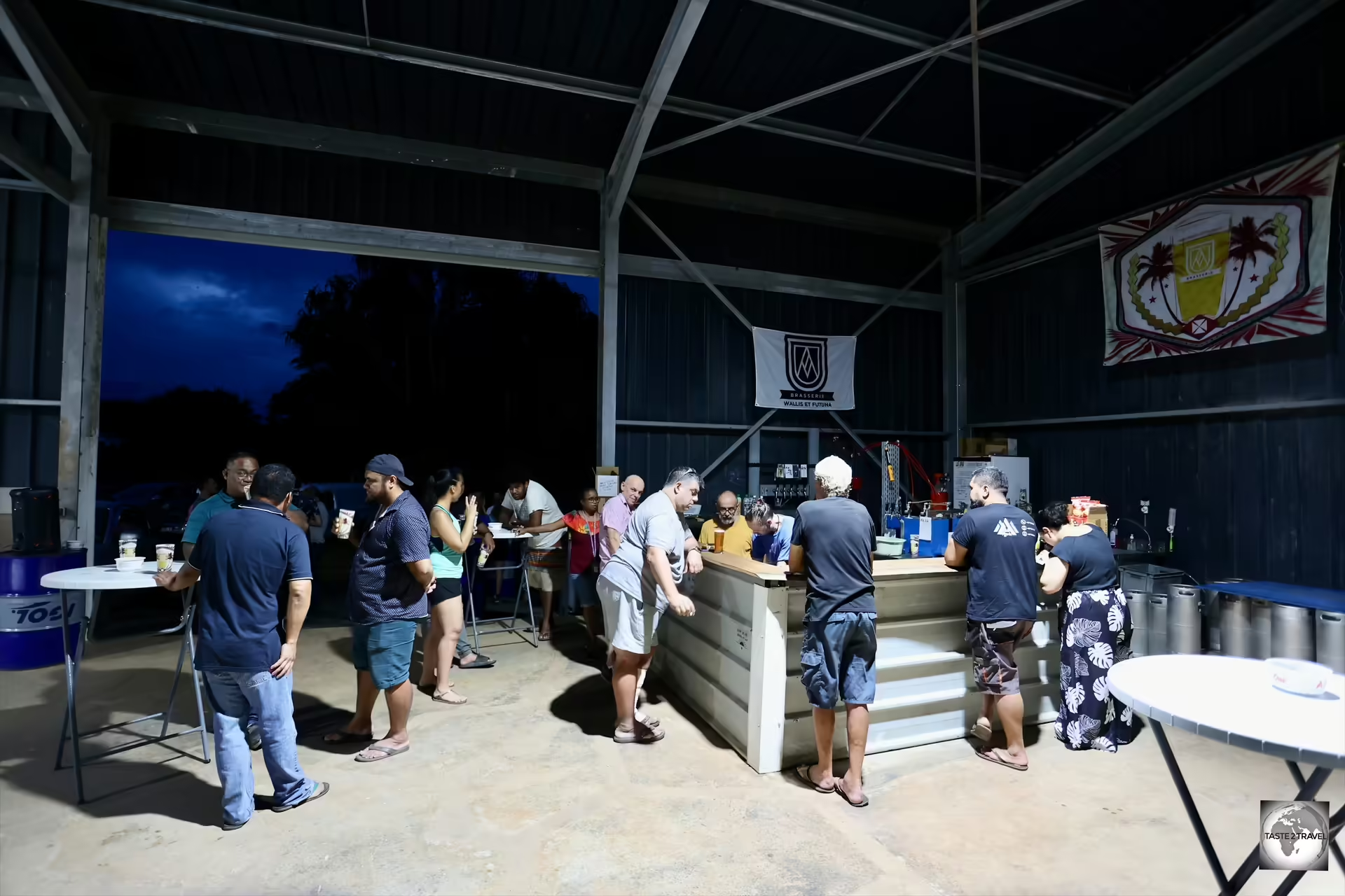
A gathering place for locals, the bar at <i>Brasserie d'Uvea</i> on a Friday night.

A gathering place for locals, the bar at Brasserie d’Uvea on a Friday night.

For those who consider themselves to be a beerologist, libationist, beer devotee, wert guru, beer maven, beer expert or a hophead, a highlight of a visit to Wallis Island would have to be the opportunity to enjoy the excellent craft beers direct from the Brasserie d’Uvea bar.

The bar at <i>Brasserie d'Uvea</i> opens every Friday and Saturday evening.

The bar at Brasserie d’Uvea opens every Friday and Saturday evening.

Located inside the brewery, the brasserie bar opens at 5 p.m. on both Friday and Saturday evening, with happy hour commencing at 6 p.m. and ending at 7 p.m.

Boxes of bottled craft beer for sale at Brasserie d'Uvea on Wallis Island.

Boxes of bottled craft beer for sale at Brasserie d’Uvea on Wallis Island.

Drinks at the bar normally cost 500 XPF (US$4.50) for a half pint or 1,000 XPF (US$9.00) for a pint. However, during happy hour, you can enjoy 2 for 1 drinks.

In addition to the three bottled beers, there were two other craft beers on sale at the bar which were available only from the keg: a New England Pale Ale (labelled as “NEIPA“) and another beer called “Fia Fia” – another excellent, tasty ale!

The three different types of craft beers can be purchased direct from the brasserie.

The three different types of craft beers can be purchased direct from the brasserie.

If you are staying on the island, you can purchase a 20-litre keg of craft beer for XPF 15,000 and a tap kit for XPF 5,000.

The brewery is located in the south of Wallis Island, in the remote village of Halalo.

Housed inside a huge, purpose-built, tin shed, on the corner of the main road (RT1) and the turnoff to the historic Tongan fort (Talietumu Fortress), the brasserie produces 50,000 litres of excellent craft beer annually.

Brasserie d’Uvea contacts: 

Visa Requirements

My arrival form for Wallis and Futuna.

My arrival form for Wallis and Futuna.

Wallis and Futuna, as a French overseas collectivity, follows a visa policy similar to that of mainland France, but with some specific considerations due to its remote location and unique status.

My entry and exit stamps from Hihifo Airport, the only international gateway to Wallis and Futuna.

My entry and exit stamps from Hihifo Airport, the only international gateway to Wallis and Futuna.

For European Union (EU) and European Economic Area (EEA) Citizens:

Visa Exemption: Citizens of EU and EEA member states (blue on the visa policy map), as well as Switzerland, do not need a visa to enter Wallis and Futuna. They can stay, work, and reside in the territory without any special permit.
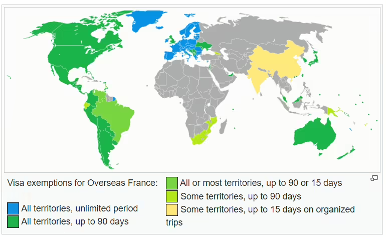
Visa policy for Overseas France.

Visa policy for Overseas France.
Source: Wikipedia

For Citizens of Countries with Visa-Free Agreements with France:

Visa Exemption: Nationals of countries that have visa-free agreements with France (dark green on the visa policy map) can enter Wallis and Futuna without a visa for short stays (typically up to 90 days within a 180-day period). This includes countries like the United States, Canada, Australia, New Zealand, Singapore, Japan, and many others.

For Citizens of Other Countries:

Visa Requirement: Nationals of countries that do not have visa-free agreements (gray on the visa policy map) with France must obtain a visa before traveling to Wallis and Futuna. This is generally the same type of visa required to enter France or other French overseas territories.

Types of Visas:

Short-Stay Visa: For visits up to 90 days, such as tourism, family visits, or business trips. This is similar to a Schengen visa but specifically for French overseas territories.
Long-Stay Visa: For stays longer than 90 days, including work, study, or permanent residency. Applicants must meet specific criteria and provide documentation related to the purpose of their stay.

Special Considerations:

French Overseas Visa: It’s important to note that the visa for Wallis and Futuna is specifically for French overseas territories and is not the same as a Schengen visa, which covers mainland France and other Schengen Area countries. If a visa is required, it must be explicitly valid for French overseas territories.
Non-Schengen Area: Wallis and Futuna is not part of the Schengen Area, so Schengen visas do not apply here. Visitors must have a visa valid specifically for Wallis and Futuna or French overseas territories if required.

Entry Requirements:

Passport Validity: Visitors typically need a passport valid for at least three months beyond the planned departure date.
Proof of Accommodation and Return Ticket: Travelers may be asked to show proof of accommodation and a return or onward ticket.

You can check your visa requirements by consulting the Visa Policy of Wallis and Futuna Islands.

Getting There

Hihifo Airport on Wallis Island is the only international gateway to Wallis and Futuna.

Hihifo Airport on Wallis Island is the only international gateway to Wallis and Futuna.

Air

Wallis and Futuna each have an airport, however, the only international gateway is Hihifo Airport (IATA: WLS) which is located in the north of Wallis Island.

The only airline to serve Wallis and Futuna is Aircalin, the national carrier of New Caledonia.

Wallis Island

Arriving at Hihifo Airport on Wallis Island.

Arriving at Hihifo Airport on Wallis Island.

The only international gateway to Wallis and Futuna Islands is Hihifo Airport (IATA: WLS) which is located at the northern end of Wallis Island.

A traditional carved wooden sign at Wallis "Hihifo" Airport.

A traditional carved wooden sign at Wallis “Hihifo” Airport.

The airport is located 5.6 km north of Mata-Utu, the capital city.

It was constructed during WWII by US Seabees (i.e. United States Naval Construction Battalions) in March 1942 as a bomber field.

Flights

Aircalin at Wallis Airport.

Aircalin at Wallis Airport.

The only airline which flies to Wallis is Aircalin, the national carrier of New Caledonia, who operate 2x weekly flights from Noumea, every Saturday and Monday.

The distance between Noumea Airport (NOU) and Wallis (WLS) is 2,100 km (1,300 mi).

Monopoly Operator

Aircalin flight SB330, on approach to Wallis Airport.

Aircalin flight SB330, on approach to Wallis Airport.

For decades, Aircalin have had exclusive operating rights to Wallis and Futuna and they fight hard to protect their monopoly operation.

Able to charge high ticket prices and chop and change their schedule at will, the long-suffering residents of Wallis and Futuna would dearly love to have a choice of airlines when flying.

During the recent 6-week period of unrest on New Caledonia, all flights from Noumea airport were suspended. This meant that no flights operated to Wallis and Futuna.

The Aircalin office on Wallis Island is located in the small shopping arcade behind the SEM Supermarket.

The Aircalin office on Wallis Island is located in the small shopping arcade behind the SEM Supermarket.

In the past, the much larger, Fiji Airways have applied for permission to fly to Wallis from Nadi Airport.

The distance between Nadi Airport (NAN) and Wallis Island Airport (WLS) is just 845 km (525 mi) with a flight time of 1 hour.

However much they try, Fiji Airways have never been able to secure landing rights at Wallis Airport as they have always been blocked by Aircalin.

Unlike sleepy Noumea airport, which has just a couple of flights per day, the much busier Nadi airport is the main aviation hub for the South Pacific, offering regular flights to Australia, New Zealand, North America, Singapore and most Pacific Island nations.

Fiji Airways also offer much more competitively priced airfares, compared to Aircalin.

Fiji Airways and Nadi Airport would be a win-win for the residents of Wallis and Futuna.

Given a choice, the residents of Wallis and Futuna would most likely vote with their feet and Aircalin know this!

It is for this reason, that the New Caledonian carrier continues to block any application by Fiji Airways to offer flights to Wallis and Futuna.

In the meantime, Aircalin continue to charge at least €700 for a return ticket from Noumea to Wallis.

They also continue to chop and change their schedule.

Originally, when I booked my ticket from Noumea to Wallis in August, Aircalin offered flights 3x flights per week – on Monday, Thursday and Saturday. I booked to fly in and out of Wallis on a Thursday.

However, a week before I was due to fly, Aircalin cancelled both of my flights and scrapped all of the Thursday flights, leaving just the Saturday and Monday flights.

I had just a few days to reschedule my flights which was done by the helpful staff at the Aircalin office in Sydney.

The check-in area at Wallis Airport.

The check-in area at Wallis Airport.

Ticket Cost
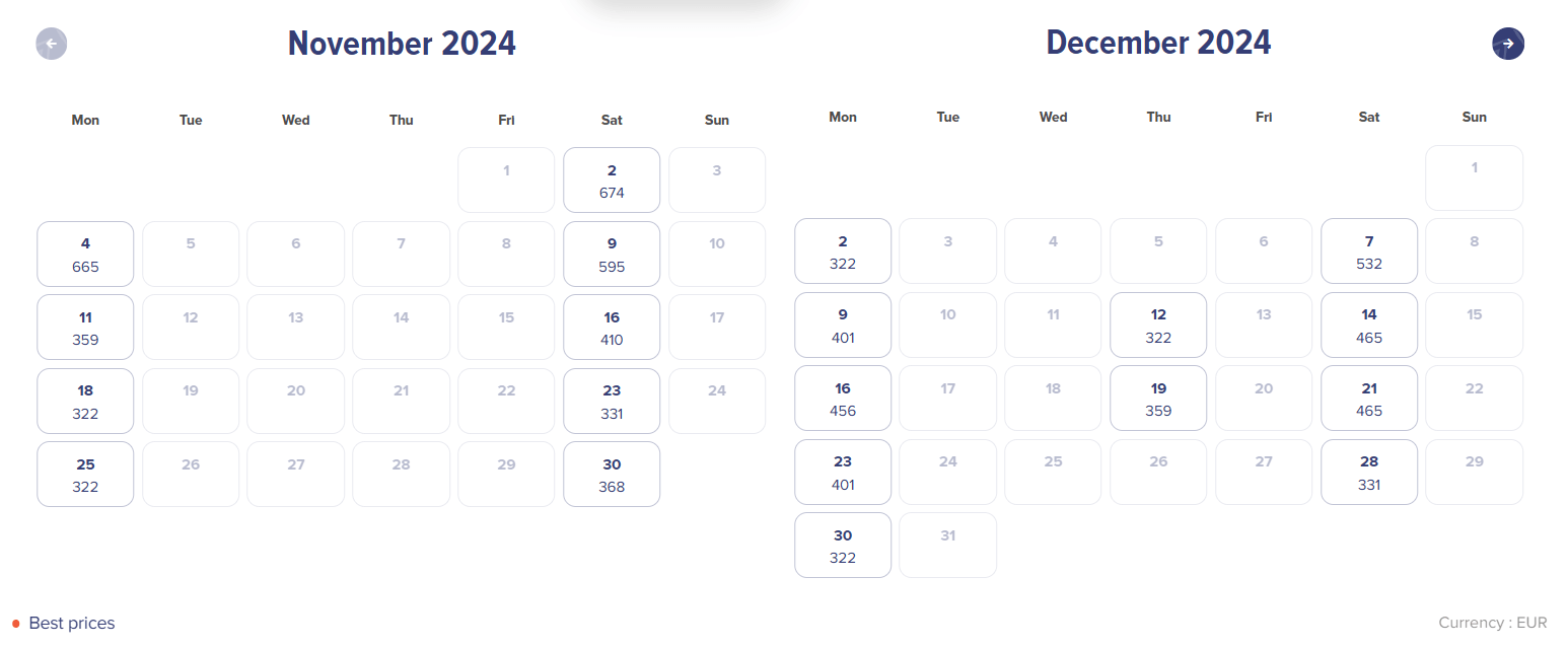
A view of Aircalin one-way fares between Noumea and Wallis (in Euro).

A view of Aircalin one-way fares between Noumea and Wallis (in Euro).

Due to its monopoly position, Aircalin are able to charge whatever they wish for those travelling to Wallis and Futuna.

A typical return airfare between Noumea and Wallis costs around €700 (US$760) but, if the lower fare classes are sold out on the dates you wish to travel, you could end up paying more than €1,000 for a return flight.

The much shorter, 1.5-hour, flight between Nadi and Wallis is priced at around 3/4 of the cost of the flight from Noumea.
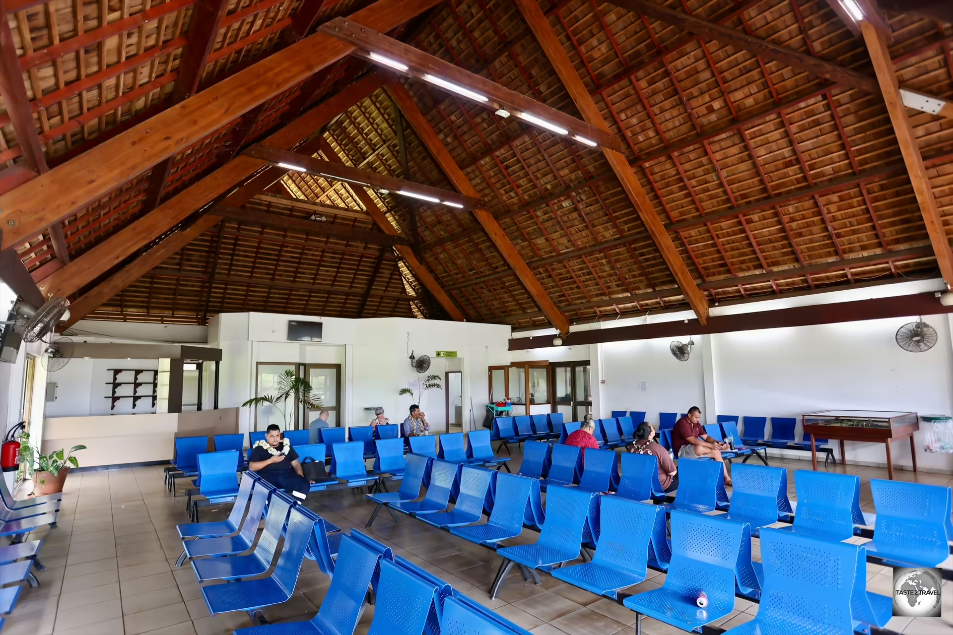
The departure lounge at Wallis Airport.

The departure lounge at Wallis Airport.

Airfare comparison – Noumea to Wallis versus Nadi to Wallis

There are 4 different fare types offered by Aircalin between Noumea and Wallis. The following represent the cheapest available (one-way) airfares, on the same day, in each class:

  • Economy Saver: between Noumea and Wallis = €322
  • Economy Value: between Noumea and Wallis = €359
  • Economy Flex: between Noumea and Wallis = €456
  • Premium Economy: between Noumea and Wallis = €556

Fares offered by Aircalin between Nadi and Wallis. The following represent the cheapest available (one-way) airfares, on the same day, in each class:

  • Economy Saver: between Nadi and Wallis = €240
  • Economy Value: between Nadi and Wallis = €283
  • Economy Flex: between Nadi and Wallis = €377
  • Premium Economy: between Nadi and Wallis = €434
My boarding pass, flying with Aircalin, from Noumea to Wallis Island.

My boarding pass, flying with Aircalin, from Noumea to Wallis Island.

Flight Routings

Each flight operates from Noumea to Wallis with a transit stop at Nadi International Airport (IATA: NAN).

The order of the transit stop in Fiji is switched between the two flights with the Saturday flight stopping at Fiji on the way to Wallis while the Monday flight stops at Fiji after leaving Wallis.

Saturday flight routing:

  • (Flight SB330) Noumea – Nadi – Wallis
  • (Flight SB331) Wallis – Noumea

Monday flight routing:

  • (Flight SB340) Noumea – Wallis
  • (Flight SB341) Wallis – Nadi – Noumea

Futuna Island

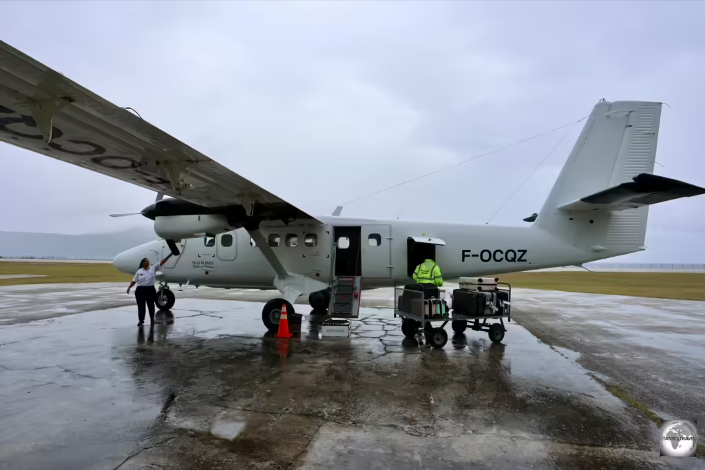
This single aircraft, operated by Air Loyauté, connects Wallis and Futuna Island twice a day.

This single aircraft, operated by Air Loyauté, connects Wallis and Futuna Island twice a day.

Futuna Island lies 234 km (145 mi) southwest of Wallis Island, about halfway between Wallis Island and Fiji.

Futuna Airport 'boutique'.

Futuna Airport ’boutique’.

Pointe Vele Airport (IATA: FUT) is the airport serving Futuna Island. There are no international flights arriving here!

Air Loyauté arriving at Futuna Airport.

Air Loyauté arriving at Futuna Airport.

Located in the south-east corner of the island, the airport is located 10 kilometres (6 mi) east of Leava, the capital of Futuna.

The waiting area at Futuna Airport.

The waiting area at Futuna Airport.

Air Loyauté, a carrier from New Caledonia, operate twice daily flights between Wallis and Futuna Islands using a small de Havilland Canada DHC-6 Twin Otter with a seating capacity for 12 passengers.

The check-in desk at Futuna Airport.

The check-in desk at Futuna Airport.

A return flight between Wallis and Futuna costs 29,800 XPF (EUR €249.80 / USD$277.85). 

The office of <i>Wallis Voyages</i> in downtown Mata-Utu.

The office of Wallis Voyages in downtown Mata-Utu.

Tickets, which cannot be booked online, must be booked through Wallis Voyages who can be contacted via email at:  wallisvoyages@mail.wf
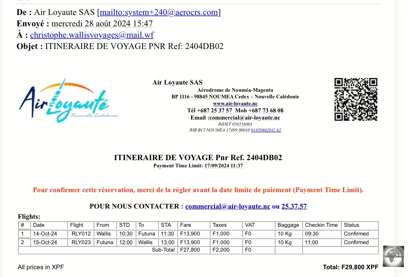
A copy of my flight ticket from Wallis to Futuna Island.

A copy of my flight ticket from Wallis to Futuna Island.

Flights tend to be booked out weeks in advance so it’s best to book your seat as far in advance as possible.

Your email will most likely be answered by the very helpful Christophe Laurent, who speaks French and English.

Air Loyauté baggage tags from FUT to WLS airport.

Air Loyauté baggage tags from FUT to WLS airport.

Christophe also holds the key to the Wallis Museum and is the man to contact if you wish to arrange a visit to the one-room museum.

Contact details for Christophe:

Airport Transport

There are no taxis or public transport on Wallis and Futuna. You will need to organise an airport transfer with your accommodation provider.

Wallis Island

On Wallis Island, my Airbnb host, Manuel, provided airport transfers at a rate of XPF 1,000/trip (US$9.00).

Futuna Island

On Futuna Island, my hotel, Hotel FiaFia, provided airport transfers for XPF 3,000/ trip (US$27.00).

Sea

No commercial boat company exists in this remote territory, therefore travel between Wallis and Futuna is exclusively by plane.

Getting Around
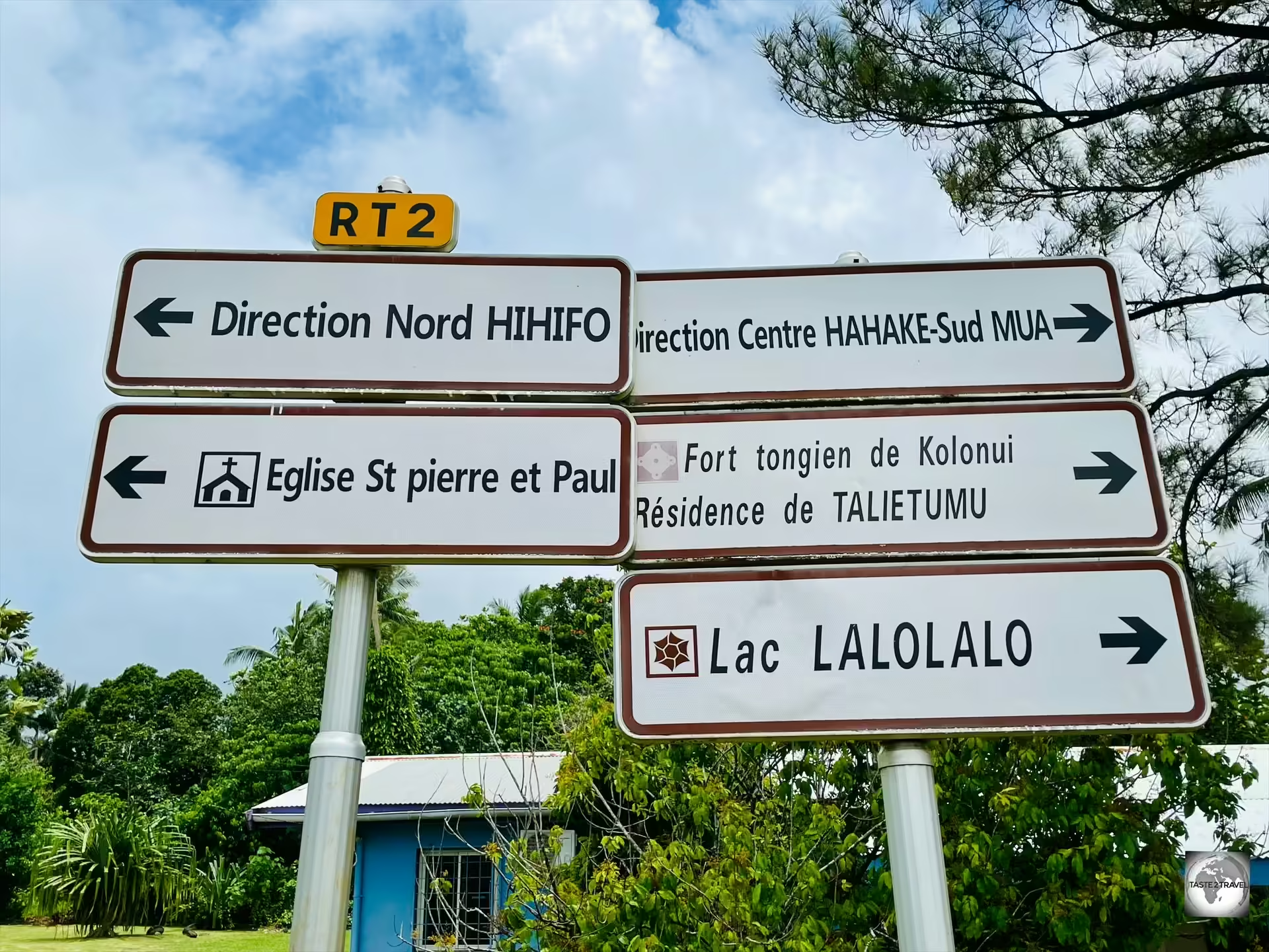
This sign, which is located directly outside the airport, is one of the few road signs on Wallis Island.

This sign, which is located directly outside the airport, is one of the few road signs on Wallis Island.

There is no public transport, nor are there any taxis, on either Wallis or Futuna Islands. 

The only feasible way to explore the islands, and to maximise your time, is with a rental car.

Wallis Island has about 120 km of roads, much of which are paved. There are no street lights at night and very few road signs, since everyone knows where they are going!

A single coastal ring road circumnavigates the very mountainous Futuna Island.

While you can travel through the interior of Wallis Island, you cannot access the near-vertical interior of Futuna Island (unless you hike).

Rental Car

Exploring Wallis Island in my Toyota Hilux rental car, which I hired through Lausikula guesthouse.

Exploring Wallis Island in my Toyota Hilux rental car, which I hired through Lausikula guesthouse.

With a complete lack of public transport on the islands, a rental car is the only feasible transport option on Wallis and Futuna.

I organised a rental car through Manuel, the owner of Lausikula guesthouse who charged me XPF 8,000/day (US$72.74) for a trusty Toyota Hilux.

Fuel on the island costs XPF 200 (US$1.82) per litre.

Please refer to the ‘Accommodation‘ section for more details.

All car license plates on Wallis and Futuna are suffixed with 'WF'.

All car license plates on Wallis and Futuna are suffixed with ‘WF’.

There are several providers of rental cars on Wallis and Futuna, all of which are listed on the transport page of the Wallis and Futuna Tourism website.

Interestingly, insurance companies do not insure cars on Wallis and Futuna so people drive their cars until they fall apart.

I once passed a car which had obviously rolled at some point. The entire car was smashed and flattened and all windows were broken, but the owner was still able to drive the car and so he did!


That’s the end of my Wallis and Futuna Islands Travel Guide.

If you wish to leave any comments/ feedback, you can do so using the form below.

Safe Travels!
Darren


Further Reading

Following is a list of other travel guides from the Pacific Ocean region:

Pitcairn Islands Photo Gallery

Cover Photo: Pitcairn Islands Photo Gallery

Pitcairn Islands Photo Gallery

This is a Pitcairn Islands Photo Gallery from taste2travel.

To read about this destination, please refer to my Pitcairn Islands Travel Guide.


All images are copyright! If you wish to purchase any images for commercial use, please contact me via the Contact page.


About taste2travel!

Hi! My name is Darren McLean, the owner of taste2travel.

I’ve been travelling the world for 36 years and, 239/251 countries and territories (189/193 UN countries), and seven continents later, I’m still on the road.

Taste2travel offers travel information for destinations around the world, specialising in those that are remote and seldom visited. I hope you enjoy my content!

Ever since I was a child, I have been obsessed with the idea of travel. I started planning my first overseas trip at the age of 19 and departed Australia soon after my 20th birthday. Many years later, I’m still on the road.

In 2016, I decided to document and share my journeys and photography with a wider audience and so, taste2travel.com was born.

My aim is to create useful, usable travel guides/ reports on destinations I have visited. My reports are very comprehensive and detailed as I believe more information is better than less. They are best suited to those planning a journey to a particular destination.

Many of the destinations featured on my website are far off the regular beaten tourist trail. Often, these countries are hidden gems which remain undiscovered, mostly because they are remote and difficult to reach. I enjoy exploring and showcasing these ‘off-the-radar’ destinations, which will, hopefully, inspire others to plan their own adventure to a far-flung corner of the planet.

I’m also a fan of travel trivia and if you are too, you’ll find plenty of travel quizzes on the site.

Photography has always been a passion and all the photos appearing in these galleries were taken by me.

If you have any questions or queries, please contact me via the contact page.

I hope you this gallery and my website.

Safe travels!

Darren


Follow me on Instagram: 

[instagram-feed feed=1]

Pitcairn Islands Travel Guide

Cover Photo: Pitcairn Islands Travel Guide.

Pitcairn Islands Travel Guide

This is a Pitcairn Islands Travel Guide from taste2travel.com

Date Visited: June 2024

Introduction

Visiting Pitcairn Island has always been a long-held travel dream!

I used to look at its remote location on a world map and dream that one day I would make the long journey there.

Pitcairn Islands Travel Guide: The much-photographed longboat shed at Bounty Bay.

The much-photographed longboat shed at Bounty Bay.

It was only recently that I decided to allocate the time and the (considerable) funds to make my dream come true.

Pitcairn is a truly remote destination which is unlike any of the other place which I have visited.

My journey to Pitcairn was also surprisingly emotional – the realisation of a big travel dream, combined with the wonderful, welcoming, warmth and hospitality for which the Pitcairners are famous, a warmth which embraces you immediately upon arrival and holds you close until you leave.

A view of the rugged south coast of Pitcairn Island.

A view of the rugged south coast of Pitcairn Island.

Upon arrival on the island, everyone gathers to welcome you, and upon departure everyone turns out at Bounty Bay to bid you farewell. A truly special and moving experience.

A visit to one of the remotest, populated, islands on earth is a special travel experience, and offers an insight into a unique way of life which is currently lived by the 40+ souls who call Pitcairn Island home.

A miniature model of the HMS Bounty, inside a bottle, at the Pitcairn Museum.

A miniature model of the HMS Bounty, inside a bottle, at the Pitcairn Museum.

Most of the population are descendants of the HMS Bounty mutineers, a story which has been immortalised in books, and three Hollywood movies:

  • Mutiny on the Bounty (1935), starring Clark Gable and Charles Laughton.
  • Mutiny on the Bounty (1962), starring Marlon Brando and Trevor Howard.
  • The Bounty (1984), starring Mel Gibson and Anthony Hopkins.
A view of the only church on Pitcairn Island - the Seventh-day Adventist church in Adamstown.

A view of the only church on Pitcairn Island – the Seventh-day Adventist church in Adamstown.

The shortest possible trip to Pitcairn Island requires 8 days and will cost approximately:

  • US $6,556
  • NZD $10,716
  • AUD $9,892
  • EUR €6,110

There are 4 major cost components, all of which are fully described in the ‘Costs‘ section below.

The cost of travelling to Pitcairn Island will only ever increase in price. Recently, the cost of a berth on the supply ship – the MV Silver Supporter – has increased by NZ$500!

A volcanic island, Pitcairn is surrounded by the deep waters of the Pacific Ocean, with waves pounding against high coastal cliffs.

A volcanic island, Pitcairn is surrounded by the deep waters of the Pacific Ocean, with waves pounding against high coastal cliffs.

If you wish to travel to Pitcairn, it’s best to do it sooner rather than later!

I have included detailed information below which will allow you to book your own Pitcairn Island adventure.

Highly recommended!

Breadfruit and the Bounty

Originally from Tahiti, Breadfruit can now be found growing around the world.

Originally from Tahiti, Breadfruit can now be found growing around the world.

The story of breadfruit is integral to the story of Pitcairn Island. Without breadfruit, there would be no story!

The story of British involvement with Breadfruit is fascinating and starts with Captain James Cook, who first discovered it on Tahiti (French Polynesia) where he referred to it as ‘bread growing on a tree’.

A display at the Pitcairn Museum - "Breadfruit - that evil fruit".

A display at the Pitcairn Museum – “Breadfruit – that evil fruit”.

Upon his return to England, Captain Cook reported its existence to the King of England, who decided that a starchy staple that grows on a tree would be ideal to feed a growing slave population in the Caribbean.

The King then commissioned Captain William Bligh to sail the HMS Bounty to Tahiti, to collect, then transplant, 150 young breadfruit trees to the Caribbean.

This journey ended abruptly, off the coast of Tonga, when Fletcher Christian and crew staged their Mutiny on the Bounty!

This was the culminating event of what had been an exceptionally long and arduous sea voyage which was captained by Bligh – someone who apparently had a difficult and abrasive personality.

A plaque, which overlooks Bounty Bay, commemorates the Bounty Mutineers and their Tahitian wives, who first settled on Pitcairn Island in 1790.

A plaque, which overlooks Bounty Bay, commemorates the Bounty Mutineers and their Tahitian wives, who first settled on Pitcairn Island in 1790.

The mutineers returned to Tahiti, collected their girlfriends/ wives and set sail for anywhere off the radar. They eventually settled on the very remote Pitcairn Island.

Meanwhile, after rowing 6,500 kilometres west, across the Pacific Ocean, in a small row boat, Captain Bligh reached Batavia (Jakarta) where he then hitched a ride back to England.

Determined as ever, Bligh set sail again for Tahiti, collected a new batch of breadfruit trees, then transported them to the Caribbean, where they were planted on various British-controlled islands.

Today, Breadfruit is a staple of the Caribbean diet and forms an integral part of Jamaican BBQ.

One of the original breadfruit trees, which was planted by Bligh, can be seen today in the Kingstown Botanical Garden, in the capital of Saint Vincent and the Grenadines!

The British eventually transported breadfruit around the world, planting it in those tropical areas where it could grow, providing a valuable food source for young colonies and settlements.

The story of the dispersal of breadfruit from its native Tahiti is a global one, and has been included in many of my Travel Guides. I have included links (above) to those reports which contain mentions of the breadfruit story.


Norfolk Island Travel Guide

To fully understand the story of Pitcairn Island, you also need to understand the story of Norfolk Island, presently an Australian territory which is located a mere 6,271 km (3,300 mi) west of Pitcairn Island, on the other side of the Pacific Ocean.

Norfolk Island is actually home to most of the descendants of the HMS Bounty mutiny.

Following the mutiny, the mutineers settled on Pitcairn Island with their Tahitian wives.

With nothing much to do, by the 1850’s, the swelling population had outgrown its tiny (5 square km) island home.

The Pitcairners appealed to Queen Victoria for a larger piece of real estate, somewhere in the Pacific Ocean.

She responded by allocating the recently abandoned, former penal colony, of Norfolk Island, which lies 1,673 km off the east coast of Australia.

The connection between Norfolk Island and Pitcairn Island is symbolised through the many Norfolk Island pine trees which can be found growing on Pitcairn Island.

The connection between Norfolk Island and Pitcairn Island is symbolised through the many Norfolk Island pine trees which can be found growing on Pitcairn Island.

On the 3rd of May 1856, a British government-supplied ship relocated 194 Pitcairn Islanders (the entire population) to Norfolk Island, who arrived at their new home on the 8th of June 1856.

The Pitcairn Islanders originally lived in the abandoned convict buildings in Kingston before moving to their own 50-acre land grants, where they built homes and farms.

A plaque written in <i>Norfuk</i>, a creole language from Norfolk Island, based on English and Tahitian, installed on the 200th anniversary of the settlement of Pitcairn Island.

A plaque written in Norfuk, a creole language from Norfolk Island, based on English and Tahitian, installed on the 200th anniversary of the settlement of Pitcairn Island.

The descendants of the Pitcairn Islanders now make up about a half of the island’s population, and a walk through the rows of headstones in the islands’ one cemetery in Kingston show those who were direct descendants of the Bounty mutineers, with numerous gravestones bearing the surnames of Christian, Quintal, McCoy, Adams and Young.

The Norfolk Island Museum includes relics from the Bounty which were carried to the island when Pitcairn was abandoned in 1856.

Sometime later, a small group of Pitcairners decided to return to Pitcairn Island, where they resettled.

You can read more about Norfolk Island in my Norfolk Island Travel Guide.


Location

Adamstown PCRN 1ZZ, Pitcairn Islands

Pitcairn Island is a remote island located in the southern Pacific Ocean. It is part of the Pitcairn Islands group, which is a British Overseas Territory.

Hilly Pitcairn Island offers spectacular views in all directions.

Hilly Pitcairn Island offers spectacular views in all directions.

The territory consists of Pitcairn Island, Oeno Island, Henderson Island and Ducie Island, with Pitcairn being the only inhabited island.

The island is situated roughly halfway between Peru and New Zealand, and it is one of the most isolated inhabited islands in the world.

Waves, crashing against the south coast of Pitcairn Island.

Waves, crashing against the south coast of Pitcairn Island.

The capital of Pitcairn Island is Adamstown, which is located roughly 2,170km (1,350 miles) south-east of Tahiti, just over 6,600km (4,100 miles) from Panama, 5,310km (3,300 miles) from Auckland, New Zealand and 7,495 km (4,657 mi) from Sydney, Australia.

The Pitcairn Islands were formed by a centre of upwelling magma called the Pitcairn hotspot.

A former volcano, Pitcairn Island is surrounded by treacherous coastal cliffs such as 'Down Rope'.

A former volcano, Pitcairn Island is surrounded by treacherous coastal cliffs such as ‘Down Rope’.

Pitcairn Island is a volcanic remnant primarily formed of tuff, where the north side of the cone has been eroded.

A view of Adamstown, the only settlement on Pitcairn Island.

A view of Adamstown, the only settlement on Pitcairn Island.

Adamstown, the main settlement on the island, lies within the volcanic basin.

Water Supply

Water at my homestay was stored in these rainwater tanks which held 70,000 litres of fresh rainwater.

Water at my homestay was stored in these rainwater tanks which held 70,000 litres of fresh rainwater.

Pitcairn Island has no rivers, springs, reservoirs or any source of fresh water.

The only water supply on the island is collected from the sky. Rainwater is collected in tanks from the rooftops of each home.

Early water tanks on Pitcairn Island were made from wooden palings which made them very leaky.

Early water tanks on Pitcairn Island were made from wooden palings which made them very leaky.

My homestay featured 4 large tanks which held 70,000 litres of fresh, pure rainwater.

The water was served chilled and also lightly carbonated as Sparkling Pitcairn water. It was just like San Pellegrino!

Chemical-free, it tasted amazing.

People

My hosts, Heather and Kerry Young are both descendants of Bounty Mutineers.

My hosts, Heather and Kerry Young are both descendants of Bounty Mutineers.

As of April 2021, the total resident population of the Pitcairn Islands was 47.

It is rare for all the residents to be on-island at the same time; it is common for several residents to be off-island for varying lengths of time visiting family or for medical reasons.

A diaspora survey completed by Solomon Leonard Ltd in 2014 for the Pitcairn Island Council and the United Kingdom Government projected that by 2045, if nothing were done, only three people of working age would be left on the island, with the rest being very old.

In addition, the survey revealed that residents who had left the island over the past decades showed little interest in coming back.

Most of the residents of Pitcairn Island are descendants of the mutineers from HMS Bounty and their Tahitian companions.

The small population, and remote location, make Pitcairn Island one of the least populous territories in the world.

Population Decline

An abandoned property on Pitcairn Island.

An abandoned property on Pitcairn Island.

Pitcairn’s population has significantly decreased since its peak of over 200 in the 1930s, to fewer than fifty permanent residents today.

The island’s community recognise that for the long-term sustainability, re-population is the number one strategic development objective.

The government is committed to attracting migrants, offering free land packages.

Only two children were born on Pitcairn in the 21 years prior to 2012.

However, in this period other children were born to Pitcairn mothers who travelled to New Zealand to receive increased health care safeguards during pregnancy and childbirth.

In 2014, the government’s Pitcairn Islands Economic Report stated that “no one will migrate to Pitcairn Islands for economic reasons as there are limited government jobs, a lack of private sector employment, as well as considerable competition for the tourism dollar.”

The Pitcairners take turns to accommodate those few tourists who occasionally visit the island.

Schooling

There is one school on Pitcairn Island which has been closed for the past two years due to the fact that there are no school-age children living on the island.

Religion

The only church on Pitcairn Island is the Seventh-day Adventist church in Adamstown.

The only church on Pitcairn Island is the Seventh-day Adventist church in Adamstown.

In 1886, the Seventh-day Adventist layman John Tay visited Pitcairn and persuaded most of the islanders to accept his faith.

He returned in 1890 on the missionary schooner Pitcairn with an ordained minister to perform baptisms.

Installed outside the church is this bell from the <i>HMS Dainty</i>, a British Royal Navy destroyer which was decommissioned in 1971.

Installed outside the church is this bell from the HMS Dainty, a British Royal Navy destroyer which was decommissioned in 1971.

Since then, the majority of Pitcairn Islanders have been Adventists.

A view of the interior of the Seventh-day Adventist church on Pitcairn Island.

A view of the interior of the Seventh-day Adventist church on Pitcairn Island.

There is just one church on Pitcairn which is the Seventh-day Adventist church in Adamstown.

It’s open for service each Saturday from 11 am to 12 pm and is the main social event on the island each week with locals gathering in the square after the service.

Due to Adventism, the main working day on the island, when most businesses and the one museum is open, is Sunday.

Health

One of the requirements for those wishing to travel to Pitcairn Island is to provide Pitcairn Tourism with a copy of your travel insurance policy which must include medical evacuation coverage.

Pitcairn Island is a long way from the nearest hospital – which is in Papeete, the capital of French Polynesia, 2,320 km to the north-west.

Since there is no airport on Pitcairn, and helicopters cannot reach the island, any medical evacuation involves the slow journey on the supply ship (if it’s not on one of its quarterly trips to New Zealand) to Mangareva.

Once in Mangareva, a special medi-vac flight will need to be organised to fly a patient to Papeete hospital which is a 1,650 km (4-hour) flight.

One medical emergency occurred on the island when a local experienced appendicitis.

At the time, the supply ship was in New Zealand.

The only available option was to use the longboat to travel 540-km in the open ocean to Mangareva.

Unfortunately the patient died before the boat could reach Mangareva.

There is one small clinic on Pitcairn Island and one doctor (currently an Australian) who serves on a yearly contract basis.

Pitcairn Reed Warbler

The Pitcairn reed warbler is the only bird which is endemic to Pitcairn Island.

The Pitcairn reed warbler is the only bird which is endemic to Pitcairn Island.

The Pitcairn reed warbler is the one and only bird which is endemic to Pitcairn Island.

The Pitcairn reed warbler, the only land bird on Pitcairn Island.

The Pitcairn reed warbler, the only land bird on Pitcairn Island.

Locally known as the “sparrow”, it used to be common throughout the island, where it is the only land bird.

Although listed as 'endangered', the Pitcairn reed warbler can be seen throughout the island.

Although listed as ‘endangered’, the Pitcairn reed warbler can be seen throughout the island.

It was formerly classified as a vulnerable species by the IUCN due to its small range, but new research has shown it to be rarer than it was believed.

I found the Pitcairn reed warbler often in banana trees, where it feeds off of any exposed fruit.

I found the Pitcairn reed warbler often in banana trees, where it feeds off of any exposed fruit.

Consequently, it was up-listed to endangered status in 2008.

Wildlife

The only wildlife you are likely to see on Pitcairn Island is the odd wild (but very cute) cat!

The only wildlife you are likely to see on Pitcairn Island is the odd wild (but very cute) cat!

There is no wildlife on Pitcairn Island, except for a few wild, but very cute, cats who are kept busy keeping the local rat population in check!

Some of these cats have been adopted by the Pitcairners.

Previously, there was a large population of wild goats but these were culled!

Pitcairn Island Tourism

For all things related to tourism on Pitcairn Island, you should refer to the Pitcairn Island Tourist Office website.

Tourism plays a major role on Pitcairn, being the main revenue-maker for the island!

Tourism is the focus for building the economy.

It focuses on small groups coming by charter vessel and staying at “home stays”.

As of 2019, the government has been operating the MV Silver Supporter as the island’s only dedicated passenger/ cargo vessel, providing adventure tourism holidays to Pitcairn on a regular basis.

Tourists stay with local families and experience the island’s culture while contributing to the local economy.

Providing accommodation is a growing source of revenue, and some families have invested in private self-contained units adjacent to their homes for tourists to rent.

Pitcairn Government

For all things government, you should refer to the Pitcairn Government Website.

Shopping

Pitkern Artisan Gallery

My souvenir of Pitcairn - a woven basket which was woven by Daphne Warren, an octogenarian weaver and the last of her kind (glasses case provides scale).

My souvenir of Pitcairn – a woven basket which was woven by Daphne Warren, an octogenarian weaver and the last of her kind (glasses case provides scale).

While the journey to one of the remotest places on planet Earth can be long, those wishing to purchase products from Pitcairn Island can do so without leaving home, thanks to the online Pitkern Artisan Gallery.

While orders can be placed online in a matter of minutes, it can take several months to receive your shipment.

All orders are first dispatched from Pitcairn Island to New Zealand on the quarterly supply ship.

Once in New Zealand, shipments enter into the international mail system and will then be forwarded onto customers around the world.

Pitcairn Honey

Pitcairn honey on toast for breakfast at my homestay.

Pitcairn honey on toast for breakfast at my homestay.

One especially popular item from this remote outpost is Pitcairn Honey – which is often sold out due to high demand.

A jar of Pitcairn honey (as pictured above) currently sells for US$35!

Pitcairn bees, which have existed in blissful isolation for centuries, are known for their good health and purity. They produce a honey of intense, unique, subtle flavour.

Beehives on Pitcairn Island, home to the purest honey in the world!

Beehives on Pitcairn Island, home to the purest honey in the world!

I was fortunate to be able to enjoy Pitcairn honey on my morning toast while staying with Heather and Kerry Young.

You can purchase Pitcairn honey online through the PIPCO website although all deliveries from the island are dispatched on the quarterly supply ship to New Zealand where they are then posted to customers around the world.

Other honey-related products (e.g. Honey soap) are available for purchase from the Pitkern Artisan Gallery.

General Store 

The General Store in Adamstown is the only mini-market on the island.

The General Store in Adamstown is the only mini-market on the island.

Located in the Pamai Centre, the General Store is the only mini-market on the island.

Built in 2020, with funds from the European Union, the Pamai Centre is the only commercial centre on the island, housing the General Store, Post Office and Treasury Office.

The General Store sells a limited range of grocery and household items which arrive on the island every 3-months on the supply ship from New Zealand.

The store is closed more than its open! During my visit, it was open only on Sunday morning for about 2 hours!

Flag

The Flag of Pitcairn Island.

The Flag of Pitcairn Island.

The Pitcairn flag features a Blue Ensign with the Pitcairn coat of arms on the fly side.

The design was suggested by the Island Council in December 1980 and approved on 2 April 1984.

It was first flown in May 1984, during a visit by the then-governor Sir Richard Stratton.

The flag of Pitcairn Islands, flying over the main square in Adamstown.

The flag of Pitcairn Islands, flying over the main square in Adamstown.

The Pitcairn coat of arms features several symbols relevant to the ancestral history and culture of the Pitcairn Islanders, most of whom are descended from the sailors who mutinied on the HMS Bounty in 1789.

The blue, yellow and green of the shield symbolise the island of Pitcairn rising from the Pacific Ocean, while the anchor and Bible are symbols of the Bounty.

The crest of Pitcairn Islands.

The crest of Pitcairn Islands.

The shield is surrounded by a green and gold wreath, and crested by a helmet bearing a wheelbarrow and a slip of miro, a local tree, which represents the role agriculture played in helping the mutineers survive on the island.

Time Zones

Pitcairn Island's time zone is GMT-8.

Pitcairn Island’s time zone is GMT-8.

Pitcairn Island is located in the GMT -8 time zone, along with most of the west coast of Canada and the United States.

  • There is a one-hour time difference between Papeete (GMT -10) and Mangareva (GMT -9).
  • There is a one-hour time difference between Mangareva (GMT -9) and Pitcairn Island (GMT -8).

WiFi

Despite its remote location, Pitcairn Island enjoys incredibly fast WiFi thanks to Starlink, high speed satellite internet, which is the brain child of Elon Musk and SpaceX.

Television

ABC (Australia) is the only TV channel which is received by the satellite on Pitcairn Island.

ABC (Australia) is the only TV channel which is received by the satellite on Pitcairn Island.

There is one satellite on Pitcairn Island which picks up one TV channel – ABC Australia.

However, thanks to super-fast internet from Starlink, most locals watch online streaming services such as Netflix, YouTube etc.

Philately

The stamps of Pitcairn Island make for inexpensive souvenirs.

The stamps of Pitcairn Island make for inexpensive souvenirs.

Stamps from remote islands are always popular with philatelists around the world, and with Pitcairn Island being one of the remotest islands, its stamps are especially popular.

The sale of stamps is an important source of revenue for tiny Pitcairn Island.

The sale of stamps is an important source of revenue for tiny Pitcairn Island.

Pitcairn Island stamps used to be sold online by the Pitcairn Islands Philatelic Bureau but, since 2021, are sold online through Tower Mint in the UK.

The Pitcairn Island post office is located in the one small commercial centre in Adamstown.

The Pitcairn Island post office is located in the one small commercial centre in Adamstown.

If you are ordering stamps online, you will receive your stamps much faster from Tower Mint, who dispatch from the UK, rather than from Pitcairn Island post office, where all items are dispatched on the quarterly supply ship to New Zealand and then posted from there.

I purchased this sheet of Pitcairn stamps for NZ$16! It will one day be framed and displayed on a wall. An ideal souvenir of Pitcairn Island!

I purchased this sheet of Pitcairn stamps for NZ$16! It will one day be framed and displayed on a wall. An ideal souvenir of Pitcairn Island!

On the island, stamps can be purchased at the Pitcairn Islands General Post Office in Adamstown.

The post office is located in the Pamai Centre, alongside the General Store and the Treasury Office.

Like everything else on the island, the post office is closed more than it’s open!

The best time to visit is Sunday morning when the post office is open from 8 am to 10 am.

Introducing Charlene, the friendly and helpful postmaster on Pitcairn Island.

Introducing Charlene, the friendly and helpful postmaster on Pitcairn Island.

The main benefit of purchasing stamps from the post office is that they will be postmarked with the (rather plain) Pitcairn Islands postmark.

The (somewhat plain) Pitcairn Islands postmark.

The (somewhat plain) Pitcairn Islands postmark.

It would be nice to see some artwork on the postmark – maybe an image of the HMS Bounty.

A display of stamps for sale at the Pitcairn post office.

A display of stamps for sale at the Pitcairn post office.

The post office displays the latest postage stamps and has all matter or philatelic items available for purchase.

Postcards

The post office sells a range of post cards - excellent gifts for friends and family.

The post office sells a range of post cards – excellent gifts for friends and family.

The only place to purchase postcards is at the post office.

I don’t normally send post cards but Pitcairn is no ordinary destination and many requests for postcards were received from family and friends!

Whenever will people have the opportunity to receive a postcard from such a remote corner of the world?

All postal items from Pitcairn Island are sent to New Zealand on the quarterly supply ship from where they enter the international postal system.

Currency

The New Zealand dollar (NZD) is the official currency of Pitcairn Island.

The New Zealand dollar (NZD) is the official currency of Pitcairn Island.

The official currency of Pitcairn Islands is the New Zealand Dollar (NZD).

As a British Overseas Territory, Pitcairn Islands do not have their own currency, so they use the New Zealand Dollar as their official currency.

The New Zealand Dollar is also used in other Pacific Island nations, such as Niue, Tokelau, and the Cook Islands, which are also associated with New Zealand.

The official currency of Pitcairn Island is the New Zealand Dollar (NZD).

The official currency of Pitcairn Island is the New Zealand Dollar (NZD).

While the New Zealand dollar is the official currency, many prices are quoted in United States dollars (USD) which are also widely accepted on the island.

Banking Services

There are no banks on Pitcairn Island, however, cash advances, on credit card, are available at the Treasury Office, which is located in the Pamai Centre, between the post office and the general store.

ATMs

There are no ATMs on Pitcairn Island.

Credit Cards

Credit Cards are only accepted at the Treasury Office for the purpose of cash advances.

Costs

A trip to Pitcairn isn’t cheap. The high cost of travel ensures that the island only receives the most dedicated and determined of visitors.

There are four main cost components involved with a trip to Pitcairn. They are:

  1. A return flight to Papeete, French Polynesia from wherever you are located in the world (e.g. US$1,200 from San Francisco).
  2. A return flight from Papeete to Mangareva (US$886).
  3. A return trip on the MV Silver Supporter supply ship (NZ$6000 – approximately US$3,670).
  4. Four days accommodation on Pitcairn Island (US$800).

Therefore, a one-week trip to Pitcairn Island will cost approximately:

  • US $6,556
  • NZD $10,716
  • AUD $9,892
  • EUR €6,110

This does not include any accommodation costs in French Polynesia. 

Cost item 1

Papeete, the capital of Tahiti, is the international gateway for trips to Pitcairn Island.

Papeete, the capital of Tahiti, is the international gateway for trips to Pitcairn Island.

Flights to Papeete (pronounced as pah-pay-eh-tay) are limited and, hence, expensive!

The following airlines provide international flights to/ from Papeete:

  • Air France – flies to/ from Los Angeles, Paris–Charles de Gaulle
  • Air New Zealand – flies to/ from Auckland
  • Air Rarotonga – flies to/ from Rarotonga
  • Air Tahiti Nui – flies to/ from Auckland, Los Angeles, Paris–Charles de Gaulle, Seattle/Tacoma, Tokyo–Narita
  • Aircalin – flies to/ from Nadi, Nouméa
  • French Bee – flies to/ from Paris–Orly, San Francisco
  • Hawaiian Airlines – flies to/ from Honolulu
  • United Airlines – flies to/ from San Francisco

A typical return airfare from San Francisco, with United Airlines, costs around US$1,200 while a return airfare from Auckland, with Air New Zealand, typically costs around US$1,100.

Cost item 2 

My Air Tahiti flight at Mangareva.

My Air Tahiti flight at Mangareva.

The only airline which flies between Papeete and Mangareva (the main island in the Gambier Islands group) is Air Tahiti who fly the 1,640 km trip twice a week – every Tuesday and Saturday.

The MV Silver Supporter times its schedule to coincide with the Tuesday flight. You fly into Mangareva on a Tuesday and fly out again the following Tuesday.

The cost for a return flight to Mangareva is typically US$886. 

With such an expensive airfare, to what is a stunningly beautiful and truly remote part of the world, it would be a shame to treat the Gambier Islands as simply a transit point.

At the end of my trip to Pitcairn, I stayed longer in Mangareva, departing on the Saturday flight, which gave me 4 days to explore the Gambier Islands.

Highly recommended!


Mangareva Travel Guide

The lagoon at Mangareva, the main island of the Gambier Islands, one of five archipelagoes in French Polynesia.

The lagoon at Mangareva, the main island of the Gambier Islands, one of five archipelagoes in French Polynesia.

Mangareva is the main island of the tiny Gambier Islands group, the remotest archipelago in French Polynesia.  

It’s a long way to the Gambier Islands from Papeete, (a flight of 4-hours and a distance of 1,640 km) and it’s not cheap to reach, with a typical return airfare costing US$886.

I decided it was worth spending some time exploring the Gambier Islands before flying back to Papeete.

When would one ever visit this part of the world again? 

For a unique, authentic experience far away from anywhere, I would recommend spending some days on the very relaxed and sleepy Mangareva.

I have included information for the Gambier Islands in my French Polynesia Travel Guide.


Cost item 3

The MV Silver Supporter is the dedicated supply and passenger ship for Pitcairn Islands.

The MV Silver Supporter is the dedicated supply and passenger ship for Pitcairn Islands.

The cost of a return passage on the Pitcairn Island supply ship – the MV Silver Supporter – is NZ$6000!

The cost has recently increased from NZ$5,500 which is a decision made in London by the UK government and not a decision made by anyone on Pitcairn Island.

A berth on the MV Silver Supporter can be booked on the Pitcairn Islands Tourism website.

Locals travel on the boat for a flat fee of NZ$500 – even if travelling all the way to Tauranga, New Zealand!

The boat can carry a maximum of 12 passengers in 6 twin-share cabins.

Please refer to the ‘Getting There‘ section below for full details on how to book.

Cost item 4

'Big flower' - the stylish and modern home of Heather and Kerry Young, my homestay on Pitcairn Island.

‘Big flower’ – the stylish and modern home of Heather and Kerry Young, my homestay on Pitcairn Island.

With a complete lack of hotels, accommodation on Pitcairn Island is in the form of homestays, with a typical homestay costing US$200 per night.

The cost includes all meals and return transfers from Bounty Bay on a 4WD quad bike!

A four day stay on the island will be billed at 4 x US$200 = US$800. 

Please refer to the ‘Accommodation‘ section below for full details on how to book.

Sightseeing

A map in Adamstown indicates places, sights and walking trails on Pitcairn Island.

A map in Adamstown indicates places, sights and walking trails on Pitcairn Island.


Pitcairn Island Virtual Tour

Interesting in viewing some of the sights of Pitcairn Island from the comfort of your armchair?

You can do so through the virtual tour page on the Pitcairn Islands Tourism Website.


Videos:

Following are three videos taken from the back of the quad bike while exploring Pitcairn Island with my informative host, Kerry Young.


Bounty Bay

A view of Bounty Bay from Adamstown.

A view of Bounty Bay from Adamstown.

Named after the HMS Bounty, Bounty Bay is the one harbour which connects Pitcairn Island to the outside world.

Due to the bay’s shallow depth (15 metres), ships must moor offshore.

With no airport on the island, the bay serves a crucial role as a point of entry and exit to the island for people and goods.

Quad bikes, the most common vehicle on Pitcairn Island, parked at Bounty Bay.

Quad bikes, the most common vehicle on Pitcairn Island, parked at Bounty Bay.

The mutineers sailed the Bounty to Pitcairn Island and destroyed it by fire in the bay, thereby committing themselves to their remote island home and ensuring that no passing boat would locate the Bounty and the hiding mutineers.

All travellers to Pitcairn are brought by longboat into Bounty Bay.

Unloading the quarterly supply shipment at Bounty Bay.

Unloading the quarterly supply shipment at Bounty Bay.

Pitcairn currently uses one aluminum longboat, built to the islander’s specifications, and named “Moss”.

The boat is around 13 metres in length and can carry up to 10 tonnes of cargo at any one time.

All goods which arrive on the quarterly supply ship – the MV Silver Supporter, are shipped to shore using the “Moss”.

This single longboat is of vital importance to the island.

A view of the longboat shed at Bounty Bay from Adamstown.

A view of the longboat shed at Bounty Bay from Adamstown.

Bounty Bay is connected to Adamstown by a concrete road which winds its way up the ‘Hill of Difficulty‘.


Video:

Travelling up the ‘Hill of Difficulty’, from Bounty Bay, after my arrival on Pitcairn Island.

The quad bike, which is loaded with myself, and my luggage, is driven by Kerry Young, my host.


Adamstown

A road sign in Adamstown, the capital of Pitcairn Island.

A road sign in Adamstown, the capital of Pitcairn Island.

Pitcairn Museum

The one museum on Pitcairn Island is open every Sunday morning.

The one museum on Pitcairn Island is open every Sunday morning.

Established in 2005, the Pitcairn Island Museum includes archaeological material from the earliest Polynesian settlers, as well as artefacts from HMS Bounty.

Views of the informative displays at the Pitcairn Museum.

Views of the informative displays at the Pitcairn Museum.

Originally, volcanic Pitcairn Island was used as a stone quarry by Polynesian seafarers who used the volcanic stones to build adzes and other weapons and tools.

The museum provides interesting insights into early Polynesian settlement of the island.

A view of the Pitcairn Museum.

A view of the Pitcairn Museum.

Most of the displays are dedicated to the HMS Bounty and include a cannon which was restored by the Queensland Museum, before being returned to Pitcairn Island.

A display at the Pitcairn Museum.

A display at the Pitcairn Museum.

The museum is open every Sunday morning!

Bounty Anchor

The anchor from the HMS Bounty, on display in the main square of Adamstown.

The anchor from the HMS Bounty, on display in the main square of Adamstown.

The anchor from the HMS Bounty is on display in the main square in Adamstown.

Public Hall

The former Public Hall on Pitcairn Island.

The former Public Hall on Pitcairn Island.

The Bounty anchor is installed in front of the former Public Hall which has now been abandoned due to structural issues.

A new hall is currently being constructed across the street.

Bounty Canon

A cannon from the HMS Bounty, on display in Adamstown.

A cannon from the HMS Bounty, on display in Adamstown.

A rust-covered cannon from HMS Bounty is on display on the main street in Adamstown.

This cannon was retrieved from the watery depths of Bounty Bay.

John Adam’s Grave 

A view of John Adam's grave in Adamstown.

A view of John Adam’s grave in Adamstown.

Adamstown is named after John Adams, who was the last survivor of the Bounty mutineers who settled on Pitcairn Island in January 1790, the year after the mutiny.

Adamstown is named after John Adams, who was the last surviving Bounty mutineer on Pitcairn Island.

Adamstown is named after John Adams, who was the last surviving Bounty mutineer on Pitcairn Island.

His grave is located in Adamstown, where he is buried alongside his Tahitian wife and daughter.

Adams’ grave on Pitcairn is the only known grave site of a Bounty mutineer.

Pitcairn Cemetery

A gravestone in Pitcairn cemetery.

A gravestone in Pitcairn cemetery.

While John Adams and his wife and daughter are buried in their own private plot, the island has one cemetery in Adamstown, which is the final resting place for anyone who has passed away on the island.

As can be expected, the grave stones reflect the island’s Bounty heritage with most markers bearing the surnames of Christian, Young, Brown etc.

Wooden Longboat

The last wooden longboat built on Pitcairn Island is on display in Adamstown.

The last wooden longboat built on Pitcairn Island is on display in Adamstown.

Everything not produced on Pitcairn arrives by sea and is shipped ashore using longboats.

In 1819 Captain Henry King donated a boat to the Island and in 1880 Queen Victoria gifted two whaleboats.

The longboats of Pitcairn are reputed to be modelled on this whaleboat pattern. Over time the boats have been modified and enlarged but essentially retain the same look.

The Pitcairners built their own boats, and up until the 1980s, the boats were made of wood.

The last wooden boat was made in 1983 and retired in 1995 when it was replaced with a New Zealand made aluminum boat.

The last wooden longboat is on display in Adamstown opposite the General Store.

Pitcairn Prison 

A view of the Pitcairn Prison which was built in 2004 to house six inmates convicted of sex offenses.

A view of the Pitcairn Prison which was built in 2004 to house six inmates convicted of sex offenses.

In the early 2000’s, tiny Pitcairn Island made worldwide news due to a sex scandal which dated back generations!

A British policewoman, Gail Cox from Kent, was stationed on Pitcairn Island in 1999 for a short-duty secondment, but during her stay she discovered evidence of historic child sex offenses.

Her report led to historic sex charges, one dating back to 1972, against a number of Pitcairn Island men.

On 24 October 2004, the Pitcairn Supreme Court convicted six of the seven accused on 35 of the 55 charges.

Views of the former prison cells at Pitcairn prison.

Views of the former prison cells at Pitcairn prison.

Those who were convicted represented most of the island’s able-bodied men.

Following the convictions, a prison needed to be built on the island to house the six inmates.

A plaque installed at the Pitcairn cemetery offers and apology for the sexual offenses of the past.

A plaque installed at the Pitcairn cemetery offers and apology for the sexual offenses of the past.

However, the only people who could construct the prison were those who had been convicted.

After they had built the prison complex, the six convicted inmates then served their time!

A view of one of the empty prison cells which have been used to accommodate tourists in the past.

A view of one of the empty prison cells which have been used to accommodate tourists in the past.

However, the men were needed on a regular basis to perform their usual, crucial, tasks on the island and hence were frequently released.

Today, the prison gate is always open and the empty cells are unlocked.

The very comfortable former cells have served multiple purposes such as tourist accommodation or even a gym.

Saint Paul’s Pool

St. Paul’s Pool, a natural lava rock pool at the westernmost point of Pitcairn Island.

St. Paul’s Pool, a natural lava rock pool at the westernmost point of Pitcairn Island.

One of the most dramatic and spectacular sights on Pitcairn Island is Saint Paul’s Pool, a natural lava rock pool at the westernmost point of the island.

A wave inundates St. Paul's Pool, a natural lava swimming pool.

A wave inundates St. Paul’s Pool, a natural lava swimming pool.

While the turquoise blue waters of the pool look inviting, the pool can be very dangerous during high sea swells, which are very common on the totally exposed Pitcairn Island!

St. Paul's Pool is not a safe place to swim during large swells.

St. Paul’s Pool is not a safe place to swim during large swells.

During such swells, large waves inundate the normally calm waters of the pool, creating strong currents that can wash you out to sea.

Pawala Valley Ridge

A distance indicator at the highest point on the island at the Pawala Valley Ridge.

A distance indicator at the highest point on the island at the Pawala Valley Ridge.

Pawala Valley Ridge, is the highest point of the Pitcairn Islands, with an elevation of 347 metres (1,138 ft).

A lookout, marked by a distance indicator, provides panoramic views in all directions.

Views over Pitcairn Island and Adamstown from the Pawala Valley Ridge.

Views over Pitcairn Island and Adamstown from the Pawala Valley Ridge.

Christian’s Cave

A sign points the way to Christian's cave on Pitcairn Island.

A sign points the way to Christian’s cave on Pitcairn Island.

One of the many hikes on Pitcairn Island is to Christian’s cave.

However, hikers should be warned that the final part of the trek is a scramble up a slippery, 45°, slope that is without any sort of track and without much in the way of traction. It’s a slope of slippery gravel and grass!

The steep, slippery slope which you must climb to reach Christian's cave.

The steep, slippery slope which you must climb to reach Christian’s cave.

The cave hike is off-limits to visiting cruise ship passengers and it is advised that you only climb the slope with an experienced local hiker such as Kerry Young, who has mapped hiking trails throughout the island.

You should also only attempt this climb if you are wearing proper hiking boots with very good grip.   

A view of the north coast of Pitcairn Island from near Christian's cave.

A view of the north coast of Pitcairn Island from near Christian’s cave.

Accommodation

A view of my beautiful homestay on Pitcairn Island - "Big Flower" - the home of Heather and Kerry Young.

A view of my beautiful homestay on Pitcairn Island – “Big Flower” – the home of Heather and Kerry Young.

With a total lack of hotels on Pitcairn Islands, all visitors are accommodated in the homes of local families.

My cosy room at 'Big Flower', the home of Heather and Kerry Young.

My cosy room at ‘Big Flower’, the home of Heather and Kerry Young.

Accommodation arrangements are to be made, and paid for, in advance through the Pitcairn Island Tourist Office.

The modern and stylish living room at 'Big Flower'.

The modern and stylish living room at ‘Big Flower’.

Accommodation options can be viewed on the Where-to-Stay page of the Pitcairn Island Tourist Office website. There are currently 12 homestays listed on the website.

The inviting outdoor area at my homestay.

The inviting outdoor area at my homestay.

With no builders on the island, locals are responsible for building their own homes, using materials which are shipped in from New Zealand on the quarterly supply ship.

It took Heather and Kerry two years to build their beautiful home which is perched on a high ledge, above Adamstown.

The view of Pitcairn Island, with Adamstown below, the MV Silver Supporter, and the endless blue of the Pacific Ocean, from my homestay.

The view of Pitcairn Island, with Adamstown below, the MV Silver Supporter, and the endless blue of the Pacific Ocean, from my homestay.

Most accommodation packages cost around US$200 per person, per day, which will be billed at US$800 for a 4-day stay.

Heather and Kerry have also built 'Little Flower' a self-contained cottage, on an adjacent block of land.

Heather and Kerry have also built ‘Little Flower’ a self-contained cottage, on an adjacent block of land.

Eating Out

All of my meals on Pitcairn, such as this delicious roast lamb dinner, were prepared by Heather Young, who is an amazing cook.

All of my meals on Pitcairn, such as this delicious roast lamb dinner, were prepared by Heather Young, who is an amazing cook.

There is no such thing as ‘Eating Out’ on Pitcairn Island – you always ‘Eat In’.

With a total lack of dining options on Pitcairn Island, home cooked meals for visitors are included in their accommodation package.

The garden at Heather and Kerry's homestay. The potatoes and onions were drying out in the sun as they had just arrived on the supply ship from New Zealand.

The garden at Heather and Kerry’s homestay. The potatoes and onions were drying out in the sun as they had just arrived on the supply ship from New Zealand.

Due to its remote location, and the unreliable nature of supply ships, locals tend to be self-sufficient when it comes to food production, with the fertile volcanic soil on the island put to good use.

Throughout the island, locals grow a wide range of fruit and vegetables.

Delicious apple pies which Heather prepared for dinner one evening.

Delicious apple pies which Heather prepared for dinner one evening.

There are pop-up gardens everywhere, and everyone has their own backyard garden.

In the garden of my homestay, there was a productive vegetable and herb garden, orange, lemon and avocado trees.

As you walk around the island, you pass many fruit trees, where the fruit can be freely picked.

A fresh batch of amazingly delicious cookies which were baked by Heather Young.

A fresh batch of amazingly delicious cookies which were baked by Heather Young.

Despite being an island surrounded by an abundance of fish and seafood most locals buy imported New Zealand meat at the General store.

One evening, Heather prepared a delicious roast lamb dinner. Divine!

Visa Requirements

One of the world's rarest passport stamps.

One of the world’s rarest passport stamps.

The Pitcairn Island passport stamp is one of the rarest passport stamps in the world.

Pitcairn Island is welcoming to all!

You can visit for up to 14 days without a visa if you plan to arrive and depart on the same ship.

The Pitcairn Island Landing Card must be completed by all arriving passengers.

The Pitcairn Island Landing Card must be completed by all arriving passengers.

You must fill in a landing card on arrival.

Passports will be stamped when you come ashore at Bounty Bay.

The immigration officer will stamp both your entry and exit stamp at the same time. You simply date your exit stamp when you depart from the island.

To stay on Pitcairn Island for more than 14 days, you must contact Pitcairn Immigration for entry clearance before making any travel plans.

If you wish to immigrate to Pitcairn, you should contact Pitcairn Immigration using the link above. 


A sad fact is, that as rare as the Pitcairn Island passport stamp is, many of the passports which bear this stamp belong to people who have never actually set foot on the island. 

Most visitors to Pitcairn arrive via cruise ships, which make a scheduled stop of just a few hours, mooring offshore from the island. 

If weather conditions aren’t favourable, the ship’s captain will most likely decide not to land passengers ashore. 

Instead, Pitcairn immigration will come on board the cruise ship and stamp passenger’s passports – in return for a payment of US$10. 

I read that on one cruise ship, 100 passengers paid to receive Pitcairn passport stamps in their passports – without ever leaving the ship. 

Sitting on a ship, offshore from anywhere, could never be considered a visit. 

I personally could never have my passport stamped with the stamp of a place which I never actually visited. 


Getting There

Pitcairn Island has no airport!

Being a rugged half-crater, rising to some 340 metres (1,100 feet) and girded by precipitous coastal cliffs, there isn’t enough flat land on Pitcairn Island for an airstrip.

The only way to reach Pitcairn Island is by boat!

However, since the island does not have a sea port, all boats must moor offshore with passengers and freight transferred to the island, through Bounty Bay, by long boat.

Although a shallow harbour, with a water depth of 15 metres, Bounty Bay is the only harbour on the island, equipped with a launch ramp accessible only by small longboats.

Access to the rest of the shoreline is restricted by jagged rocks and coastal cliffs.

Air

The nearest airport to Pitcairn Island is Totegegie Airport (IATA: GMR), an airport on Totegegie Island in the Gambier Islands, 540-km to the north-west of Pitcairn.

Totegegie Island is located 9-km across the lagoon from Mangareva.

Sea

MV Silver Supporter

The MV Silver Supporter is a dedicated passenger and cargo supply ship chartered by the Pitcairn Island government.

The MV Silver Supporter is a dedicated passenger and cargo supply ship chartered by the Pitcairn Island government.

A dedicated passenger and cargo supply ship chartered by the Pitcairn Island government, the MV Silver Supporter, which was freshly refurbished in 2019, is the principal form of transport which links Pitcairn to the outside world – specifically – Mangareva in the Gambier Islands of French Polynesia.

Every three months, the supply ship travels to Tauranga, New Zealand to collect supplies for Pitcairn Island.


Video: 

The slow voyage from Mangareva to Pitcairn Island on the MV Silver Supporter.


Mangareva lies 540 km (335 mi) north-west of Pitcairn Island, a sea voyage of 35 hours.

The MV Silver Supporter is certainly a slow boat to Pitcairn Island, travelling at just 10 knots (about 15km/h)!

Painfully slow!

Cabins

My cabin on the MV Silver Supporter.

My cabin on the MV Silver Supporter.

The MV Silver Supporter is fully air-conditioned and accommodates up to 12 passengers in 6 spacious twin cabins.

A view of my cabin on the MV Silver Supporter.

A view of my cabin on the MV Silver Supporter.

In addition to the bedroom, each cabin on this Norwegian-built ship includes ample storage space, a private bathroom and a separate office/lounge area.

A view of my cabin bathroom on the MV Silver Supporter.

A view of my cabin bathroom on the MV Silver Supporter.

Meals

Meals on board the MV Silver Supporter are served 3-times per day in the dining room.

Meals on board the MV Silver Supporter are served 3-times per day in the dining room.

In the communal dining area guests share daily meals with their fellow passengers.

A typical meal served on the MV Silver Supporter.

A typical meal served on the MV Silver Supporter.

Meals are served at the following times:

  • Breakfast is served at 7:30am.
  • Lunch is served at 11:30am
  • Dinner is served at 5:30pm

The ship also features a comfortable lounge area where guests can relax and socialise.

WiFi

The ship offers complimentary onboard Wi-Fi which is totally useless.

It’s impossible to get any kind of signal from the satellite receiver.

It would be better if the owner’s installed Starlink – just like everyone else on Pitcairn Island.

Cost

The current cost for a return journey on the MV Silver Supporter from Mangareva to Pitcairn, back to Mangareva, is NZ$6,000 (US$3,700).

This includes accommodation and all meals.

Shipping Schedule

The current shipping schedule for the MV Silver Supporter is posted on the Pitcairn Islands Tourism website.

Trip Duration

Most voyages include a 4-day stay on Pitcairn Island, allowing plenty of time to explore this tiny Pacific Island jewel.

With a 35-hour voyage, each way, from Mangareva, plus 4-days on Pitcairn Island, you will need to allow 8-days for the entire trip to Pitcairn Island.  

On the voyage to Pitcairn Island, the ship will normally arrive at Pitcairn around midnight on Wednesday night. Passengers disembark the following morning after breakfast.

Likewise, on the voyage to Mangareva, the ship will normally arrive at around midnight on Monday night. Passengers disembark the following morning after breakfast, then transfer to the airport for the flight to Papeete.

Booking a Berth 

My booking confirmation for the MV Silver Supporter which was emailed to me by Pitcairn Islands Tourism.

My booking confirmation for the MV Silver Supporter which was emailed to me by Pitcairn Islands Tourism.

Full details for booking a berth on the MV Silver Supporter are included on the Pitcairn Islands Tourism website.

Enquiries and bookings should be made through the Contact page of the Pitcairn Islands Tourism website, or by emailing Pitcairn Island Tourism at: tourism@pitcairn.pn

Journey to Pitcairn Island
The municipal ferry which connects Totegegie Airport to Mangareva, from where the MV Silver Supporter departs for Pitcairn Island.

The municipal ferry which connects Totegegie Airport to Mangareva, from where the MV Silver Supporter departs for Pitcairn Island.

All passengers to Pitcairn Island must first fly to Totegegie Airport (IATA: GMR), which is located on an uninhabited coral atoll, 9-km across the lagoon from Mangareva Island.

The only airline which flies to Mangareva is Air Tahiti, with flights operating every Tuesday and Saturday.

Since the MV Silver Supporter departs on Tuesday, most passengers fly from Papeete, to Mangareva, on the Tuesday flight.  

An early morning view of Pitcairn Island from the MV Silver Supporter.

An early morning view of Pitcairn Island from the MV Silver Supporter.

The airport is connected to Mangareva by a municipal ferry which charges CFP 1,000 for the 40-minute crossing.

All passengers must board this ferry as it’s the only means of reaching Mangareva.

Once the ferry docks at Mangareva port, the crew of the MV Silver Supporter, who will be in a small yellow tender boat, will meet and assist passengers.

The crew will load all luggage into the tender while the passengers walk 300-metres down the road to have their passports stamped with an exit stamp from French Polynesia at the local Gendarmerie office.

Note: It should be noted that, this being a French Territory, the Gendarmerie office closes for the standard, French, 2-hour lunch break from 12 noon until 2 pm. If you arrive during this time, you will need to wait for the Gendarme officer to return from lunch.

Normally, Mangareva isn’t an official entry/ exit point for French Polynesia, but, through an MOU (Memorandum of Understanding) between the British and French governments, the French have made an exception for Pitcairn Island passengers, thus allowing the local Gendarmerie to stamp passports.

Once all passports have been stamped, the passengers then return to the port to board the tender for the short transfer to the MV Silver Supporter which will be moored offshore in the lagoon.

The 35-hour journey to Pitcairn then commences.

The Pitcairn Longboat, "Moss", which will transport us to the island.

The Pitcairn Longboat, “Moss”, which will transport us to the island.

The MV Silver Supporter will normally arrive at Pitcairn Island around midnight on Wednesday night.

The transfer from the supply ship to the longboat is by way of a rope ladder.

The transfer from the supply ship to the longboat is by way of a rope ladder.

After breakfast on Thursday, it’s time to disembark.

The Pitcairn longboat – the “Moss”, will pull up alongside the MV Silver Supporter.

Boarding the "Moss" longboat at sea, for the short transfer to Bounty Bay.

Boarding the “Moss” longboat at sea, for the short transfer to Bounty Bay.

Once all luggage has been loaded, its the turn of the passengers to climb down a rope ladder ship and into the longboat.

The journey to shore, and the realisation that you are about to land on one of the remotest, populated, places on earth can be strangely emotional.

Approaching Bounty Bay on the "Moss" longboat.

Approaching Bounty Bay on the “Moss” longboat.

Upon arrival at Bounty Bay, all visitors report to the immigration officer (Brenda) who has her desk setup alongside the longboat shed.

Here, passports are stamped and arrival cards are collected.

Arrival at Bounty Bay.

Arrival at Bounty Bay.

Once you have completed formalities and collected your luggage, you’ll board a quad bike with your host for the journey up the ‘Hill of Difficulty” and on to your homestay.

Journey to Mangareva
The "Moss" longboat in the longboat shed, prior to being launched.

The “Moss” longboat in the longboat shed, prior to being launched.

The return journey to Mangareva, starts from the dock at Bounty Bay at 4pm on Sunday, when all the island turns out to bid farewell to its visitors.

This is a real social occasion with everyone coming together.

The Pitcairners are known for their warmth and hospitality and the time of departure is an emotional experience for all.

You have become a part of a close-knit community and now it’s time to say goodbye.

The heavy "Moss" longboat is launched from the boat shed by attaching a rope to a tractor which then pulls it down the boat ramp.

The heavy “Moss” longboat is launched from the boat shed by attaching a rope to a tractor which then pulls it down the boat ramp.

The first step in the departure process is launching the heavy “Moss” longboat from the boat shed into Bounty Bay.

This is done by attaching a rope to a tractor and the boat. The tractor then reverses quickly, pulling the Moss out of the boat shed and down the ramp.

The freshly launched "Moss' longboat in Bounty Bay.

The freshly launched “Moss’ longboat in Bounty Bay.

Once in the water, the Moss ties up at the wharf where all passengers and their luggage is loaded.

The Moss then heads out to sea to meet the MV Silver Supporter which is always moored offshore.

It is worth noting that the “Moss” is the only functioning longboat on Pitcairn Island at this time – a potential single point of failure for the island!


Video: 

Departing Pitcairn Island on the “Moss” longboat, on our way to board the MV Silver Supporter for the journey back to Mangareva, French Polynesia.


Once all passengers are aboard, the MV Silver Supporter commences its slow crawl back to Mangareva, arriving at around midnight on Monday night.

After breakfast on Tuesday morning, all passengers disembark, arriving at Mangareva port at 8:30 am.

First stop in Mangareva is the local Gendarmerie to get an entry stamp into French Polynesia.

From there, the municipal ferry to the airport (costs CFP 1,000) usually departs from the dock at around 9am.

The flight back to Papeete departs from Mangareva at 12 noon, arriving at 14:50.

Cruise Ships

When I arrived at Pitcairn Island, the majestic Bark Europa was visiting the island.

When I arrived at Pitcairn Island, the majestic Bark Europa was visiting the island.

Several cruise ships call at Pitcairn Island each year.

All cruise ship arrivals are listed on the Cruise Ship Schedule page on the Pitcairn Island Tourist Office website.

Cruise ships typically spend just a few hours on the island with a landing being dependent on the sea conditions and at the discretion of the ship’s captain.

If a landing isn’t possible, the Pitcairn islanders will instead set up an arts and crafts pop-up store on board the ship where purchases can be made.

Ship passengers can also pay to have their passports stamped by Pitcairn Immigration.

Getting Around

Pitcairn Island road signs.

Pitcairn Island road signs.

There is one 6.4 km (4 mi) concrete road leading up from Bounty Bay through Adamstown.

A typical country lane on Pitcairn Island.

A typical country lane on Pitcairn Island.

There are many hiking trails and gravel tracks which provide access to most corners of the island.

There are many towering banyan trees on Pitcairn Island.

There are many towering banyan trees on Pitcairn Island.

Whenever walking or hiking, caution must be front of mind since there are no medical facilities (except for a small clinic) anywhere near Pitcairn Island.

While there are no taxis on Pitcairn, Steve Christian has converted his quad bike into a deluxe ride, complete with a taxi sign.

While there are no taxis on Pitcairn, Steve Christian has converted his quad bike into a deluxe ride, complete with a taxi sign.

In the event of a medical emergency, people need to be evacuated to French Polynesia on the slow supply ship then flown to the nearest hospital which is in Papeete – a journey of many days and many thousands of miles.

Exploring Pitcairn Island with my host Kerry Young on his quad bike.

Exploring Pitcairn Island with my host Kerry Young on his quad bike.

The main modes of transport on Pitcairn Islands are four-wheel drive quad bikes and foot.


That’s the end of my Pitcairn Islands Travel Guide.

If you wish to provide feedback or leave a comment, you can do so using the form below.

Safe Travels!
Darren


Further Reading

Following is a list of other travel guides from the Pacific Ocean region:

Niue Photo Gallery

Limu pools offers magical snorkeling.

Niue Photo Gallery

This is an Niue Photo Gallery from taste2travel.

To read about this destination, please refer to my Niue Travel Guide.


All images are copyright! If you wish to purchase any images for commercial use, please contact me via the Contact page.


About taste2travel!

Hi! My name is Darren McLean, the owner of taste2travel.

I’ve been travelling the world for 36 years and, 230 countries and territories, and seven continents later, I’m still on the road.

Taste2travel offers travel information for destinations around the world, specialising in those that are remote and seldom visited. I hope you enjoy my content!

Ever since I was a child, I have been obsessed with the idea of travel. I started planning my first overseas trip at the age of 19 and departed Australia soon after my 20th birthday. Many years later, I’m still on the road.

In 2016, I decided to document and share my journeys and photography with a wider audience and so, taste2travel.com was born.

My aim is to create useful, usable travel guides/ reports on destinations I have visited. My reports are very comprehensive and detailed as I believe more information is better than less. They are best suited to those planning a journey to a particular destination.

Many of the destinations featured on my website are far off the regular beaten tourist trail. Often, these countries are hidden gems which remain undiscovered, mostly because they are remote and difficult to reach. I enjoy exploring and showcasing these ‘off-the-radar’ destinations, which will, hopefully, inspire others to plan their own adventure to a far-flung corner of the planet.

I’m also a fan of travel trivia and if you are too, you’ll find plenty of travel quizzes on the site.

Photography has always been a passion and all the photos appearing in these galleries were taken by me.

If you have any questions or queries, please contact me via the contact page.

I hope you this gallery and my website.

Safe travels!

Darren


Follow me on Instagram: 

[instagram-feed feed=1]

Niue Travel Guide

A raised limestone reef with no beaches, but plenty of cliffs and reef, Niue is affectionally known as ‘The Rock’.

Niue Travel Guide

This is a Niue Travel Guide from taste2travel.com

Date Visited: December 2023

Introduction

Affectionally known as ‘The Rock’, the tiny Pacific Ocean island of Niue is a charming, remote, off-the-beaten track destination.

A raised limestone reef with no beaches, but plenty of cliffs and reef, Niue is affectionally known as ‘The Rock’.

A raised limestone reef with no beaches, but plenty of cliffs and reef, Niue is affectionally known as ‘The Rock’.

With a small and friendly population of 1,620 Polynesians, tiny Niue is full of surprises. The name Niue (pronounced ‘Noo-ay‘) translates as ‘behold the coconut’.

A raised slab of limestone reef, the profile of Niue is similar to that of a ‘top hat’, with sheer cliffs rising up 20 metres from the sea, forming the sides of the hat.

Colourful Niuean design.

Colourful Niuean design.

The top of the hat is a large flat plateau, while the ‘rim’ of the hat is a fringing reef which surrounds the entire island. There are just a few places where narrow channels through the reef allow locals to access the sea.

Niue is entirely surrounded by a fringing reef.

Niue is entirely surrounded by a fringing reef.

The entire population lives on the plateau, with everyone living along the coast, while the empty interior of the island is uninhabited and occupied by forest and taro fields.

Niue Blue! Another perfect day in paradise!

Niue Blue! Another perfect day in paradise!

A 62 km (38 mi) ring road around the coast links all of the island’s communities. Two cross-island roads link the west and east coast, a drive of just 19 km (12 mi).

Artwork in Alofi.

Artwork in Alofi.

Most of population lives on the west coast (the leeward side of the island), in and around the main town, and administrative centre of Alofi.

The east coast (the windward side of the island) is sparsely populated, being home to a few sleepy villages.

A hidden gem - tiny Tamakautoga Beach is one of the few beaches on Niue.

A hidden gem – tiny Tamakautoga Beach is one of the few beaches on Niue.

Being surrounded by a fringing reef, Niue lacks the sandy beaches which might otherwise attract the tourist hordes. However, what the island lacks in beaches, it makes up for in other ways.

A view of Talava Arch, a highlight of Niue.

A view of Talava Arch, a highlight of Niue.

The entire coast is lined with dramatic limestone caves, chasms, arches and other geological wonders.

Well maintained sea tracks provide access to turquoise-blue swimming holes where a rich array of tropical fish can be found. There are many snorkeling opportunities on the island.

Close to the shore, the water depth is around 50 metres, while a few kilometres from shore, the water depth is 2,000 metres.

Close to the shore, the water depth is around 50 metres, while a few kilometres from shore, the water depth is 2,000 metres.

Beyond the reef, the island slopes away quickly, with water depths ranging from 50 m (165 ft) near the shore, to a depth of over 2,000 m (6,560 ft) within a few kilometres of shore.


Update: August 2024 – “Protecting Paradise: The Story of Niue”

A recently released National Geographic documentary, “Protecting Paradise: The Story of Niue”, captures the spirit of the Niueans and the beauty of this special paradise island.


Scuba Diving conditions on Niue are perfect! With an absence of sand and a lack of rivers on the island, there is nothing that disturbs the incredible clarity of the sea water. Water visibility is excellent up to 85 metres.

With excellent underwater visibility, Niue is a scuba diver's paradise.

With excellent underwater visibility, Niue is a scuba diver’s paradise.

There is one scuba diving shop on the island – the excellent and professional Niue Blue. I did a 2-tank dive with them which was a highlight of my trip. For more information, please refer to the ‘Scuba Diving‘ section below.

Enjoying scuba diving on Niue with Niue Blue.

Enjoying scuba diving on Niue with Niue Blue.

While not a cheap destination (please refer to the ‘Costs‘ section below for more information), Niue is a charming, surprising and engaging destination.

With a small and friendly local population, this tiny island will surprise and delight with all it offers.

A view of the north coast of Niue at Uluvehi.

A view of the north coast of Niue at Uluvehi.

In just over 3-hours flying time from Auckland, New Zealand, visitors to Niue will find themselves transported to another world. With its Jurassic-like geological formations and crystal-clear waters, Niue is like no other destination!

Highly recommended!

Location

Niue is a small island nation located in the South Pacific Ocean. It is situated about 2,400 kilometres (about 1,500 miles) northeast of New Zealand, within the triangle formed by the Cook Islands, Tonga, and Samoa.

Niue is known as a raised coral atoll, and its terrain is characterized by limestone cliffs, caves, and a central plateau.

A view of the reef which completely encircles Niue.

A view of the reef which completely encircles Niue.

The island has a total land area of about 260 square kilometres (100 square miles).

The coastline features a fringing reef which is backed by rugged cliffs.

Not a place for a beach holiday, Niue is a raised limestone rock, completely surrounded by reef.

Not a place for a beach holiday, Niue is a raised limestone rock, completely surrounded by reef.

The capital and largest village is Alofi, located on the western coast of the island.

While Niue is a relatively small and isolated island, it is surrounded by the vast expanse of the Pacific Ocean, making it a remote but scenically beautiful destination.

Sunset on Niue.

Sunset on Niue.

The island’s isolation and unique geography contribute to its distinct cultural and environmental characteristics.

A noticeboard on Niue illustrates cyclone intensity levels. Watch what happens to the tree at each level.

A noticeboard on Niue illustrates cyclone intensity levels. Watch what happens to the tree at each level.

Niue is located in the Pacific cyclone zone and has been battered by severe cyclones in the past.

In 2004, Cyclone Heta, a Category 5 cyclone, caused massive damage to Niue, with huge waves breaking on top of the (20 metre high) sea cliffs.

People

The 1,620 inhabitants of Niue are predominantly Polynesians.

The 1,620 inhabitants of Niue are predominantly Polynesians.

The people of Niue are known as Niueans. Home to a small, close-knit community of 1,620 souls, the population is, predominately, of Polynesian descent.

Due to its small population and close-knit community, social relationships are often tightly woven, and individuals often have multiple roles within the community.

Religion, particularly Christianity, is also an important aspect of Niuean life, and the majority of the population is affiliated with various Christian denominations.

Niueans are known for their warm hospitality and strong sense of community.

Colourful artwork adorns a small wooden building in Alofi.

Colourful artwork adorns a small wooden building in Alofi.

The culture places a high value on respect for elders and a communal approach to decision-making. Traditional customs and practices, such as dance, music, and art, play a significant role in Niuean life.

The Niuean language, closely related to other Polynesian languages, is an essential part of their cultural identity.

In recent years, Niue has faced challenges related to depopulation, with some Niueans migrating to New Zealand and other countries for better economic opportunities.

However, efforts are being made to preserve and promote Niuean culture and identity both on the island and within the diaspora.

Niuean Hiapo

Hiapo art work on display at the Niue Visitors Centre in Alofi.

Hiapo art work on display at the Niue Visitors Centre in Alofi.

Traditional bark cloth painting is something which is found throughout the islands of the south Pacific.

On Niue this lost art form, which is known locally as Hiapo, is being revived by Niuean artist Cora-Allan Wickliffe.

Hiapo art work on display at the Scenic Matavai Resort Niue.

Hiapo art work on display at the Scenic Matavai Resort Niue.

Examples of Hiapo art adorn the walls of the Niue Visitors Centre and the Scenic Matavai Resort Niue.

Flag

The flag of Niue.

The flag of Niue.

The flag of Niue was adopted on 15 October 1975. It consists of the Union Jack in the upper left corner with a star in the middle of the Union Jack and four stars forming a diamond around it.

It is very unusual for a flag based on a British ensign design, in having not only a yellow background, but also a defaced (edited) Union Jack in the canton.

The flag of Niue, flying on Niue.

The flag of Niue, flying on Niue.

The flag was designed by Patricia Rex, the wife of the then-Premier Robert Rex.

The design elements of the flag include the Union Jack, which symbolises the protection granted by the United Kingdom in 1900 after petitioning by the Kings and Chiefs of Niue.

The yellow field symbolises “the bright sunshine of Niue and the warm feelings of the Niuean people towards New Zealand and her people.”

The association with New Zealand, which took over responsibility and administration of Niue in 1901, is also represented by the four small stars that depict the Southern Cross.

The flag of Niue.

The flag of Niue.

Finally, the blue disc containing a larger star represents the deep blue sea surrounding the self-governing island of Niue

Currency

The official currency of Niue is the New Zealand Dollar (NZD).

The official currency of Niue is the New Zealand Dollar (NZD).

The official currency of Niue is the New Zealand Dollar (NZD). Niue does not have its own separate currency and has chosen to use the New Zealand Dollar as its official legal tender.

The colourful New Zealand dollar banknotes are printed on polymer.

The colourful New Zealand dollar banknotes are printed on polymer.

This arrangement is part of Niue’s status as a self-governing territory in free association with New Zealand.

As a result, the New Zealand Dollar is widely used for everyday transactions, and the Reserve Bank of New Zealand is responsible for issuing and regulating the currency in Niue. The coins and banknotes used in Niue are the same as those used in New Zealand.

Exchange Rates

The New Zealand dollar (NZD) is the official currency of Niue.

The New Zealand dollar (NZD) is the official currency of Niue.

As of December 2023, the exchange rate between the NZD and USD was:

$1 NZD = $0.60 USD

To check the current exchange rate, please click here.

Banking Services

There is just one bank on Niue – the Niue Development Bank.

The bank also serves as the one branch of the Niue Post Office.

ATMs

While there are no ATMs on Niue, cash can be accessed at the one branch of the Niue Development Bank in Alofi.

While there are no ATMs on Niue, cash can be accessed at the one branch of the Niue Development Bank in Alofi.

There are no ATMs on Niue, but you can withdraw cash at the one branch of the Niue Development Bank which is located in Alofi.

Credit Cards

Credit cards, such as MasterCard and Visa are widely accepted on Niue.

Most merchants on the island have EFTPOS terminals and prefer cashless payments.

Rarely did I need to use cash, however, it’s prudent to carry some cash from New Zealand for emergencies.

While your home bank will most likely charge you an ‘exchange’ fee for any overseas credit card transactions, businesses on Niue will additionally charge you a credit card usage fee, which is typically around 3-5% on each transaction.

Philately

The stamps of Niue are popular with philatelists around the world.

The stamps of Niue are popular with philatelists around the world.

Niue is known for issuing a variety of colourful  and thematic postage stamps.

Stamps are often issued to commemorate special occasions, anniversaries, and international events, making them not only a means of postage but also a form of cultural expression and representation for the people of Niue.

The stamps of Niue showcase local culture, history, fauna and flora.

The stamps of Niue showcase local culture, history, fauna and flora.

These stamps often feature unique designs that showcase the natural beauty, culture, history, and important events related to Niue.

The themes of Niuean stamps can vary widely, including marine life, endemic flora and fauna, cultural symbols, historical figures, and significant events.

The stamps of Niue feature scenes from this beautiful Pacific island.

The stamps of Niue feature scenes from this beautiful Pacific island.

Niue is part of the wider philatelic community and often collaborates with other countries on joint stamp issues. These joint issues may commemorate shared historical or cultural connections.

Niue Philatelic and Numismatic Corporation

The office of the <i>Niue Philatelic and Numismatic Corporation</i> (NPNC) is in a small shopping complex behind Swanson's supermarket.

The office of the Niue Philatelic and Numismatic Corporation (NPNC) is in a small shopping complex behind Swanson’s supermarket.

While on the island, stamps can be purchased from either the one branch of Niue Post which is housed inside the Niue Development Bank branch in Alofi or from the Niue Philatelic and Numismatic Corporation (NPNC), which is in a small shopping complex, behind Swanson’s supermarket.

Niue First Day Covers (FDC's) at the Niue Philatelic and Numismatic Corporation.

Niue First Day Covers (FDC’s) at the Niue Philatelic and Numismatic Corporation.

Also available from the NPNC are specially issued Niue commemorative coins, which are produced by the New Zealand Mint.

Folders of Niue stamps at the NPNC.

Folders of Niue stamps at the NPNC.

The staff at the NPNC can be contacted for any overseas orders.

Contact details are:

The stamps of Niue feature local flora, fauna, landscapes and cultural and historical themes.

The stamps of Niue feature local flora, fauna, landscapes and cultural and historical themes.

Internet Services

Telecom Niue is the only telecom service provider on the island.

Telecom Niue is the only telecom service provider on the island.

One of the first stops for many visitors to Niue is the office of Telecom Niue, the sole provider of telecom services on the island.

Telecom Niue does not have any international roaming agreements with foreign operators; therefore, you cannot use roaming while in Niue.

The Visitor SIM package from Telecom Niue.

The Visitor SIM package from Telecom Niue.

If you wish to have internet connection while on Niue, you will need to buy a Visitor SIM card, which can be purchased from the Telecom Niue office which is located in the Alofi Commercial Centre.

All services are provided on a fast 4G network. However, if there is a power outage in Alofi (as happened several times during my stay), internet is lost across the entire island.

A Visitor SIM costs NZ$50, is valid for 14 days and includes 6GB of data, plus unlimited local calls, and 10 minutes of calls to Australia or New Zealand.

Costs

The menu at the popular Fana Cafe.

The menu at the popular Fana Cafe.

Most people visit Niue for 7 nights, which coincides with the flight schedule. With a 2nd weekly flight now operating, it is possible to visit for 3 nights.

The cost of a holiday on Niue isn’t cheap, with the biggest expenses being flights, accommodation, car rental and food. Everything really!

Sample Costs: 

  • Coca Cola (1.5 litre bottle) at Swanson’s: NZ$7.50 (US$4.70)
  • Water (0.33 litre bottle): NZ$1.80 (US$1.13)
  • Can of beer at Crow’s Nest: NZ$5.00 (US$3.13)
  • Cafe Latte at the Crazy Uga Cafe: NZ$5 (US$3.13)
  • Scrambled eggs breakfast at Fana Cafe: NZ$15 (US$9.40)
  • Car rental (daily rate) from Niue 4×4 Rentals: NZ$60 (US$37.55)
  • Litre of fuel: NZ$3.50 (US$2.20)
  • Fish and chip meal at Crow’s Nest: NZ$11 (US$6.90)
  • Meal at the Scenic Matavai Resort Niue: NZ$30+ (US$18.80+)
  • Room at the Scenic Matavai Resort Niue: NZ$250+ (US$156+)
  • Airbnb cottage (David’s Fale): NZ$160 (US$100)
  • Return flights to Niue from Auckland with Air New Zealand: NZ$800 return (USD$500)

Shopping

Niue sarongs for sale at Niue International Airport.

Niue sarongs for sale at Niue International Airport.

Tahiono Art Gallery

Ahi Cross, who, along with her husband, artist - Mark Cross - operate the Tahiono Art Gallery in Alofi.

Ahi Cross, who, along with her husband, artist – Mark Cross – operate the Tahiono Art Gallery in Alofi.

As can be expected on a tiny, remote island, shopping opportunities are limited. There are a couple of shops in Alofi which sell locally produced artworks and handicrafts.

Despite its small population, the people of Niue are especially creative and talented. There are several artists living on the island, who produce magnificent works of art which make for ideal souvenirs.

The artwork of Mark Cross can be purchased at the Tahiono Art Gallery in Alofi.

The artwork of Mark Cross can be purchased at the Tahiono Art Gallery in Alofi.

One of the most prominent artists on the island is Mark Cross, a New Zealander who is married to a Niuean – the wonderful Ahi Cross (pictured above).

Mark and Ahi run the Tahiono Art Gallery which is located in the Alofi Commercial Centre.

The walls of the gallery display Mark’s paintings which depict Niuean scenes which are interpreted in his unique style.

Kauhi Krafts

The Kauhi Kraft shop is owned by Niuean artist Olga Wilson who is known for her floral artwork which is applied to a variety of materials, including textiles.

The Kauhi Kraft shop is owned by Niuean artist Olga Wilson who is known for her floral artwork which is applied to a variety of materials, including textiles.

Also located in the Alofi Commercial Centre is Kauhi Kraft.

This gallery/ ice cream shop is owned and operated by Niuean artist, Olga Wilson, and her husband, Alan Wilson, who is originally from Perth, Western Australia.

Olga is known for her floral artwork which she applies to a variety of materials, including textiles. If you are staying at the Scenic Matavai Resort Niue, you will dine on table runners which have been designed by Olga.

The specialty at Kauhi Kraft are hand-painted tea towels, table runners, cushion covers, sarongs and more.

The shop also serves ice cream, which is also served in the form of delicious milkshakes.

Swanson Supermarket 

Swanson Supermarket is the only supermarket on Niue.

Swanson Supermarket is the only supermarket on Niue.

The only supermarket on Niue is Swanson Supermarket, which is housed in the Swanson Commerical Centre.

Due to shipping costs, groceries on Niue are very expensive with a 1.5L bottle of Coca Cola at Swanson Supermarket costing NZ$7.50.

Due to shipping costs, groceries on Niue are very expensive with a 1.5L bottle of Coca Cola at Swanson Supermarket costing NZ$7.50.

Offering a limited range of groceries, everything at Swanson’s is expensive due to high shipping costs. Everything arrives by container on the monthly supply ship from Auckland.

By the time all shipping costs are included, everyday items end up being priced as luxury items.

As an example, a 2L bottle of Minute Maid apple or orange juice costs NZ$13, while a 1.5L bottle of any soft drink costs NZ$7.50.

A large box of cereal for NZ$18.20! Due to shipping costs, all groceries at Swanson Supermarket are very expensive.

A large box of cereal for NZ$18.20! Due to shipping costs, all groceries at Swanson Supermarket are very expensive.

If you are going to be self-catering while on Niue, it’s much cheaper to carry any packaged food items from Auckland, within your luggage allowance.

The giant Uga Crab at the Swanson Commerical Complex.

The giant Uga Crab at the Swanson Commerical Complex.

It’s hard to miss the Swanson Commerical Complex, thanks to the giant Uga Crab which has been installed on the street corner, in front of the complex.

Niue Bond Store

Next door to Swanson Supermarket is the Niue Bond Store which is the one liquor shop on the island.

Naturally, this is one of the most popular shops on the island, and sells a variety of NZ wine and beer, along with international brand spirits.

The shop also serves as Niue’s only duty-free alcohol store, with flight passengers able to shop prior to their flight back to Auckland.

K-Mark

The K-mark store is the closest thing you'll find to a real K-mart on Niue.

The K-mark store is the closest thing you’ll find to a real K-mart on Niue.

Also located in the Swanson Commerical Complex, K-Mark is the closest thing you’ll found on Niue to a real K-Mart store.

This veritable Aladdin’s Cave stocks all sorts of merchandise from toys, games, clothing, homewares and so much more.

Niue Visitor Information Centre

The Niue Visitor Information Centre is located in Alofi.

The Niue Visitor Information Centre is located in Alofi.

The Niue Visitors Information Centre in Alofi is operated by the friendly staff from Niue Tourism.

The "Tourism" license plate.

The “Tourism” license plate.

Two essential items which are available from the visitors’ centre are a map of the island plus the weekly guide which outlines the opening hours of all restaurants and cafes on the island.

Niue souvenirs for sale at the Niue Visitor's Information Centre.

Niue souvenirs for sale at the Niue Visitor’s Information Centre.

Apart from dispensing information, the visitors centre is a great place to find Niue souvenirs.

A display, at the Niue Visitors Centre in Alofi.

A display, at the Niue Visitors Centre in Alofi.

The visitors centre also includes informative cultural displays and a small display of artworks by local artists.


Contact details for the Niue Tourism:


Sightseeing

It's worth picking up a free Niue map from Niue Tourism.

It’s worth picking up a free Niue map from Niue Tourism.

The sightseeing section lists the sights of Niue, travelling around the island, in a clock-wise direction from Alofi.

A 'Welcome to Niue' sign, outside Niue International Airport.

A ‘Welcome to Niue’ sign, outside Niue International Airport.

Alofi

Tomb Point

A view of the port and the northwest coast of Niue from Tomb Point.

A view of the port and the northwest coast of Niue from Tomb Point.

Located across the road from the Alofi Commercial Centre, Tomb Point is a pleasant place to relax and take in the stunning views of the port and the west coast of Niue.

Views along the southwest coast of Niue from Tomb Point.

Views along the southwest coast of Niue from Tomb Point.

Given its close proximity to the takeaway food shops across the road, Tomb Point is an ideal place to relax with a picnic lunch while you take in the panoramic views of the rugged coastline.

A memorial stone at Tomb Point pays tribute to 150 Niuean soldiers, who departed from the port on the 13th of October 1915, to serve alongside New Zealand soldiers during WWI.

The gravestone of King Tui Toga (died 13th of June 1887), the 6th King of Niue who was also the island's first Christian King.

The gravestone of King Tui Toga (died 13th of June 1887), the 6th King of Niue who was also the island’s first Christian King.

Tomb Point serves as a graveyard for prominent Niueans, including two former Kings.

The first gravestone, as you enter the cemetery, belongs to King Tui Toga (died 13th of June 1887), the 6th King of Niue who was also the island’s first Christian King.

The gravestone of Fata-a-iki (died 1896), the 7th King of Niue.

The gravestone of Fata-a-iki (died 1896), the 7th King of Niue.

Another prominent gravestone at Tomb Point is that of King Fata-a-iki (died 1896), the second Christian Niuean monarch.

One of his first acts as patu-iki in 1877 was to send a letter to the British monarch Queen Victoria, requesting that Niue be made a protectorate of the British Empire, to protect the island from other imperial powers, although his letter (and another sent in 1895) received no replies.

Niue was finally ceded to the British Empire on 21 April 1900 by the 8th King of Niue, King Togia-Pulu-toaki.

From 1900 to 1901, Niue was ruled by the United Kingdom.

In 1901, the island was annexed by New Zealand, which administered it in the name of the British Empire.

On 26 September 1907, New Zealand attained the status of dominion, becoming the Dominion of New Zealand, and the British monarch from then on reigned over Niue in his or her capacity as monarch of New Zealand.

The current monarch of Niue is King Charles III.

Taoga Niue Museum

The very worthwhile Taoga Niue Museum tells the story of the history and culture of Niue.

The very worthwhile Taoga Niue Museum tells the story of the history and culture of Niue.

Taoga Niue Museum is a national museum and cultural centre located in the new government complex in Alofi heights.

The only museum on Niue, it is located next door to the new parliament building – the Fale Fono II, and includes a small number of engaging displays which tells the story of Niue.

If you wish to gain a better understanding of the history and culture of Niue, the Taoga Niue Museum is a compulsory stop.


Access 

  • Entry Fee: $10.00 (Kids & Students FREE)
  • Opening Hours: Monday – Friday (9:00 AM – 3:00 PM)
  • Closed: Saturdays, Sunday & Public Holidays

Coastal Niue

Palaha Cave

A view of the large cavern at Palaha Cave, one of many sea caves on Niue.

A view of the large cavern at Palaha Cave, one of many sea caves on Niue.

A short, clearly signposted, sea track in Tuapa village leads down to this shoreline cave.

Palaha Cave is a large, multi-level, cavern which opens out onto the pounding sea. The cave is full of stalactites and stalagmites in various ​​vivid colours, thanks to the presence of different minerals.

The view out to sea from inside the Palaha Cave.

The view out to sea from inside the Palaha Cave.

Namukulu Boat Ramp

A view of the northwest coast of Niue from the Namukulu boat ramp.

A view of the northwest coast of Niue from the Namukulu boat ramp.

Located in the northwest corner of Niue, the Namukulu boat ramp is one of just two such ramps on the island.

Thanks to a small channel in the reef, local fisherman are able to launch their boats from this spot!

Limu Pools

Limu pools offers magical snorkeling.

Limu pools offers magical snorkeling.

A short drive further north along the coast, a clearly marked sea track leads down to the magical and enchanting world of the Limu Pools.

This is a popular place for snorkeling, which can be done in small, protected, turquoise-coloured pools.

The well-maintained sea track which leads down to Limu Pools.

The well-maintained sea track which leads down to Limu Pools.

Most of the coastal sights on Niue are accessed via short (200-metre-long) sea tracks. These ‘tracks’ are well-maintained walking paths with hand-rails and grip pads to prevent slipping.

Matapa Chasm

A view of the spectacular Matapa Chasm.

A view of the spectacular Matapa Chasm.

Further north along the coast, the next sight of interest is the spectacular Matapa Chasm.

The chasm is accessed via a flat, 200-metre-long sea track which leads from the road, through an ancient chasm to the coast.

Matapa Chasm is a mix of cooler, fresh water – which sits on top of warmer sea water. While swimming, you can feel the cooler fresh water cooling the top of your body, while the warmer sea water warms your legs.

The chasm is a great place for swimming and snorkeling, although on incoming and outgoing tides, the movement of water from the sea can cause strong currents inside the chasm.

Talava Arches

A view of Talava Arch, a highlight of Niue.

A view of Talava Arch, a highlight of Niue.

Also, from the same car park as Matapa Chasm, a longer, 1.5 km walk leads to the awesome sight which is the Talava Arches. 

The track to the arches requires sturdy walking shoes and is uneven in places. The total walking time is around 45 minutes (return journey) so a bottle of water should be carried.

A view of Talava Arch from inside a sea cave.

A view of Talava Arch from inside a sea cave.

The track ends at yet another spectacular sea cave which offers dramatic views of the arch. In order to fully explore the cave, you will need to use a rope to descend down towards the sea.

Although not a technical climb, the ropes are there to aid balance and to prevent slipping.

The perfectly framed limestone formations at Talava Arches.

The perfectly framed limestone formations at Talava Arches.

It is at Talava Arches that you can best appreciate the fact that Niue is a raised limestone reef. Everywhere, you are surrounded by cliffs of ancient seabed, and everywhere you walk, you are stepping on fragments of fossilised coral.

Mutalau

At the northern tip of Niue sits the lonely and isolated outpost of Mutalau.

In an unfortunate incident in 1863, the village was raided by a Peruvian slave-ship, and many men were kidnapped and taken to Callao (the port city near Lima, Peru).

Vanilla is an important export product for Niue.

Vanilla is an important export product for Niue.

The village has more than 12,000 vanilla vines, which is about 33 percent of Niue’s total.

Uluvehi

A view of the north coast of Niue from inside one of the caves at Uluvehi.

A view of the north coast of Niue from inside one of the caves at Uluvehi.

A good, drivable, sea track leads a short distance from the village of Mutalau to the coastal cliffs at Uluvehi.

The cliffs are lined with quiet, lonely caves which look out across the vast expanse of the Pacific Ocean.

A view of the north coast of Niue at Uluvehi.

A view of the north coast of Niue at Uluvehi.

Locals store their canoes safely, high up on the cliffs, away from the raging surf below.

Liku

A view of the east coast from a sea cave at Liku.

A view of the east coast from a sea cave at Liku.

Continuing around the island in a clock-wise direction from Mutalau, the coastal road turns south and heads along with very lonely and mostly uninhabited east coast, passing through the sleepy settlements of Lakepa, Tautu and Liku.

A sea track leads through a cave an onto the reef at Liku.

A sea track leads through a cave an onto the reef at Liku.

At Liku, a hidden, drivable sea track leads to yet more dramatic coastal cliffs.

To find the sea track, you should drive across the grassy field behind Liku church and look for an opening in the forest. The unsealed road runs for about 1 km before reaching a parking area at the coast.

From here a track leads down to a cave which provides access to the reef.

Hikulagi Sculpture Park

The centerpiece of the Hikulagi Sculpture Park is the <i>‘Protean Habitat’.

The centerpiece of the Hikulagi Sculpture Park is the ‘Protean Habitat’.

Also, in Liku is the rather bizarre Hikulagi Sculpture Park which features sculptures which have been made from recycled junk.

The centrepiece of the park is the monumental sculpture called ‘Protean Habitat’ which epitomises the ideals behind the Hikulagi Sculpture Space. It’s a continuous, interactive, work-in-progress, which does not have any perception of a finite conclusion.

Based on a wooden substructure, Protean Habitat is an assemblage sculpture which is decorated with any sorts of objects found on the island. Everyone is encouraged to contribute to the artwork by attaching their found objects to the structure.

Sculptures at the Hikulagi Sculpture Park in Liku.

Sculptures at the Hikulagi Sculpture Park in Liku.

Huvalu Forest Conservation Area

A lonely road leads through the Huvalu Forest Conservation Area on Niue.

A lonely road leads through the Huvalu Forest Conservation Area on Niue.

Continuing south of Liku, the coastal road enters into the uninhabited Huvalu Forest Conservation Area, which covers a large part of the southeastern corner of Niue.

Bee hives, which are owned by the folks from Niue Honey, inside the Huvalu Forest.

Bee hives, which are owned by the folks from Niue Honey, inside the Huvalu Forest.

Hidden away inside the forest are the many beehives which are owned by Niue Honey, a company which produces what must be considered one of the purest honeys in the world.

Hakupu

The east coast village of Hakupu lies at the southern boundary of the Huvalu forest.

The east coast village of Hakupu lies at the southern boundary of the Huvalu forest.

The east coast village of Hakupu lies at the southern boundary of the Huvalu forest. The village is known for its ebony carvings.

From the main road a sea track leads to the coast where you’ll find the Anapala Chasm.

Avatele Beach and Boat Ramp

A view of Avatele Beach.

A view of Avatele Beach.

Avatele beach is home to a small stretch of sand which makes it almost unique on this rocky island.

A channel provides access through the reef for local fishing boats.

Tamakautoga Beach

A hidden gem - tiny Tamakautoga Beach is one of the few beaches on Niue.

A hidden gem – tiny Tamakautoga Beach is one of the few beaches on Niue.

Signposted off the main coastal road in the village of Tamakautoga is a hidden gem – a small patch of sandy beach!

After a super short walk down the Togulu Sea Track, you’ll find a tiny cove, Tamakautoga Beach. 

The beach is ideal for paddling, walking and snorkelling at low tide.

A small swimming hole under a rock overhang is a great place to relax during low tide.

The Okioki Mai cafe serves delicious food and cool drinks.

The Okioki Mai cafe serves delicious food and cool drinks.

Located alongside the Tamakautoga beach carpark, the Okioki Mai cafe serves take away food and refreshingly cool drinks from a lime green shipping container.

Niue Golf Course

Located opposite the airport, the Niue Golf Course offers a 9-hole course with a club house.

Located opposite the airport, the Niue Golf Course offers a 9-hole course with a club house.

The Niue Golf and Sports Club has a well-maintained, 9-hole golf course, which is across the road from Niue International Airport.

Visitors are welcome to play at any time and clubs can be hired from the Vaiolama Cafe (who also have a miniature golf course on the clifftop next to the restaurant).

Inland Niue

Two cross-island roads link Alofi to the east coast villages of Liku and Lakepa.

Two cross-island roads link Alofi to the east coast villages of Liku and Lakepa.

A couple of cross-island roads pass through the barely inhabited interior of the island, linking Alofi to the east coast settlements of Liku and Lakepa.

The 19 km drive from Alofi to Liku, and the 16 km drive from Alofi to Lakepa, passes through lush rainforests.

It is here where the few birds on Niue can be found.

There is one parrot on Niue – the Blue-crowned lorikeet which is found throughout the islands of the South Pacific.

The lorikeets are very elusive on Niue, although I did see one flash of green as I was driving across the island.

A painting of a Blue-crowned lorikeet, by artist Olga Wilson, displayed at the Kauhi Kraft shop in Alofi.

A painting of a Blue-crowned lorikeet, by artist Olga Wilson, displayed at the Kauhi Kraft shop in Alofi.

The closest I came to seeing one of these lorikeets was at the Kauhi Kraft shop in Alofi, where artist Olga Wilson has a painting of one of these elusive birds.

The barely used cross-island road between Alofi and Lakepa passes through verdant rainforest.

The barely used cross-island road between Alofi and Lakepa passes through verdant rainforest.

When you travel across the interior, it becomes clear that everyone on Niue lives on the coast. The interior is very empty and totally quiet.

The interior of Niue is used to grow Taro, a key staple on the island.

The interior of Niue is used to grow Taro, a key staple on the island.

The interior of Niue features no population centres, but is home to large tracts of primary forest with the occasional clearing occupied by fields of taro or banana and papaya trees.

Scuba Diving

The highly recommended, 'Niue Blue', is the sole scuba diving operator on Niue.

The highly recommended, ‘Niue Blue’, is the sole scuba diving operator on Niue.

Scuba diving on a raised limestone island, with an absence of sand, and an absence of rivers dumping ground water into the sea, ensures excellent visibility. Underwater, visibility on Niue can be almost up to 100 metres. It is crystal clear!   

The crew from Niue Blue, lowering our dive boat into the water.

The crew from Niue Blue, lowering our dive boat into the water.

Added into the mix are interesting underwater formations such as caves, caverns, coral-encrusted bommies, ridges, channels and much more.

There is just one dive operator on the island – the highly recommended Niue Blue, who are located next door to the Scenic Matavai Resort Niue.

Due to the excellent conditions, almost every day is a dive day on Niue with diving trips (for up to 5 divers) heading out each morning at around 7:30 am.

A two-tank dive, with full equipment rental, costs NZ$295. Not cheap, but highly worth it!

Due to the fact that there is no safe harbour on Niue, the dive boat is lowered into the sea using a crane which is installed at the main wharf.

Note: All photos from my scuba diving have been provided by Niue Blue.

During my stay on Niue, I did a two-tank dive which I would highly recommend.

Dive # 1

The first dive took us into ‘Dome Cave‘, a shoreline cave which is only accessible from underwater.

A sea snake, sleeping in the entrance of Dome Cave.

A sea snake, sleeping in the entrance of Dome Cave.

To access the cave, we swam through a beautiful blue opening (which is a favourite hangout for friendly and curious sea snakes), and used our torches to work our way up to the surface inside this dark cavern.

Scuba Diving at the amazing 'Dome Cave' with Niue Blue.

Scuba Diving at the amazing ‘Dome Cave’ with Niue Blue.

The walls of the cave are home to many large coconut crabs, while large schools of fish take refuge inside the cave entrance.

Diving inside 'Dome Cave' with Niue Blue.

Diving inside ‘Dome Cave’ with Niue Blue.

A small crack in the roof of the cave lets a little air in, so we were able to remove our regulators and breathe in the fresh air.

The water at the surface is cool, fresh water which we could drink.

Once we re-submerged, we passed through a thermocline (which plays tricks with your vision as the water is blurry and shimmery) back into the warmer sea water which sits below the fresh water.

Being a raised limestone reef, with no sand, or fresh water runoff from the island, water visibility is excellent on Niue.

Being a raised limestone reef, with no sand, or fresh water runoff from the island, water visibility is excellent on Niue.

We then exited the cave, waving good bye to a sleeping sea snake, then continued our dive.

An amazing experience!

Dive # 2

Our 2nd dive took us around some spectacular underwater bommies and ridges.

Between the ridges were open areas of sea bed where we saw one large stingray feeding.


Video:

A stingray feeding on Niue.

Video courtesy of Niue Blue


Contact Details: 

Website: https://niueblue.com/
Email: dive@niueblue.com
Phone: +683 4311
Instagram: https://www.instagram.com/niueblue/

Deep Sea Fishing

If you wish to go deep sea fishing, you should contact Alan Wilson who runs ‘Gone Fishing Niue‘.

Contacts: 

Monthly Supply Ship

Due to Niue's reef, the monthly supply ship, Olomana, must moor offshore, and transfer its containers, one at a time, to a small barge.

Due to Niue’s reef, the monthly supply ship, Olomana, must moor offshore, and transfer its containers, one at a time, to a small barge.

Almost everything on Niue has been bought to the island by the monthly supply ship, MV Olomana, which sails between Auckland and Niue.

During my visit, the supply ship was in town, unloading its valuable cargo. Goods are bought ashore at the shallow wharf in Alofi, which can be used only by flat-bottomed, smaller, vessels.

Containers from the MV Olomana are craned onto a smaller barge which transports them to shore.

Containers from the MV Olomana are craned onto a smaller barge which transports them to shore.

Due to the presence of the reef, the supply ship must moor about 400 metres offshore. A small barge is used to transfer containers to and from the ship.

Because of this slow process, the supply ship must remain in port for several days, while full containers are offloaded and empty containers are loaded.

A view of the MV Olomana, which calls at Niue every month.

A view of the MV Olomana, which calls at Niue every month.

Shipping services to Niue are operated by the Matson Shipping Company, who provide shipping services throughout the Pacific. The Olomana sails every three weeks from Auckland to Rarotonga and Aitutaki in the Cook Islands and then Niue.

During the time the ship is in port, the main road in front of the port is lined by a high wall of shipping containers.

Accommodation

The only hotel on Niue is the very good 'Scenic Matavai Resort Niue' which is perched on top of a coastal cliff, south of Alofi.

The only hotel on Niue is the very good ‘Scenic Matavai Resort Niue’ which is perched on top of a coastal cliff, south of Alofi.

Tiny Niue offers a small selection of accommodation, most of which can be viewed on the accommodation page of the Niue Tourism website.

Christmas time at the Scenic Matavai Resort Niue, the only hotel on the island.

Christmas time at the Scenic Matavai Resort Niue, the only hotel on the island.

While the regular online travel sites (Booking.com, Hotels.com etc.) offer few accommodation options, Airbnb offers five different cottages.

During my time on the island I stayed at David’s Fale, an Airbnb property, and at the Scenic Matavai Resort Niue, the only hotel on Niue.

Scenic Matavai Resort Niue

Great views of the coast of Niue from the pool area at the Scenic Matavai Resort Niue.

Great views of the coast of Niue from the pool area at the Scenic Matavai Resort Niue.

The Scenic Matavai Resort Niue is the only hotel option on Niue.

Part of the New Zealand owned and operated, Scenic Hotel Group, the Scenic Matavai Resort Niue enjoys a spectacular location, perched on the edge of a clifftop, overlooking the azure waters of the Pacific.

A view of the west coast from the Scenic Matavai Resort Niue.

A view of the west coast from the Scenic Matavai Resort Niue.

The resort is located 5 km from Niue airport and 7.5 km southeast of Alofi village.

While the resort offers complimentary airport transfers, it is recommended that you hire a car during your stay on Niue.

There is no other way to explore the island other than with your own means of transport.

My spacious and comfortable 'Superior' room at the Scenic Matavai Resort Niue.

My spacious and comfortable ‘Superior’ room at the Scenic Matavai Resort Niue.

The resort offers 56 rooms with balconies, with most rooms offering spectacular views of the Pacific Ocean.

The spacious rooms include an ensuite bathroom, tea and coffee making facilities, minibar, LCD TV (with just 3 channels which aren’t worth watching), an in-room safe, bathrobes and slippers. Everything for the discerning traveller!

Standard rooms at the Scenic Matavai Resort Niue start from NZ$250 per night.

Standard rooms at the Scenic Matavai Resort Niue start from NZ$250 per night.

Standard ‘Ocean View’ rooms start at NZ$250 per night, with ‘Superior rooms’ costing NZ$300 per night.

All room rates include a buffet breakfast.

At certain times of the year, a minimum booking of 7 nights must be made, which coincides with the flight schedule.

You can book rooms directly through the hotel website or through booking.com

Rooms at the Scenic Matavai Resort Niue include ensuite bathrobes, slippers and bathrobes.

Rooms at the Scenic Matavai Resort Niue include ensuite bathrobes, slippers and bathrobes.

As for dining options – the restaurant at the Scenic Matavai Resort Niue is the only full service restaurant on Niue and is the only restaurant on the island which is open seven days a week.

For more on the restaurant, please refer to the ‘Eating Out‘ section.

Scenic Matavai Apartments and Villa

Apartments at the Scenic Matavai Apartments and Villa complex are perched on top of the sea cliffs.

Apartments at the Scenic Matavai Apartments and Villa complex are perched on top of the sea cliffs.

In addition to the main resort, the Scenic group also offer the Scenic Matavai Apartments and Villa which is located 1.7 km north of the main resort.

A walkway onto the reef, in front of Scenic Matavai Apartments and Villa.

A walkway onto the reef, in front of Scenic Matavai Apartments and Villa.

Like the main resort, this property enjoys a spectacular cliff-top location and apartments have a very pleasant ocean outlook.  There is a sea-track down to the reef which gives access to the reef at low tide.

A view of the reef from the Scenic Matavai Apartments and Villa.

A view of the reef from the Scenic Matavai Apartments and Villa.

David’s Fale

During my stay on Niue, I spent 4 nights at David's Fale, a cosy Airbnb cottage.

During my stay on Niue, I spent 4 nights at David’s Fale, a cosy Airbnb cottage.

My first 4 nights on Niue were spent in a cosy and comfortable Airbnb cottage – David’s Fale.

The living room at David's Fale in Alofi.

The living room at David’s Fale in Alofi.

The cottage included one bedroom with a queen-sized bed, a bathroom with washing machine, a living room and a kitchen which allowed me to self-cater.

The cottage is located in Alofi, amidst the swaying coconut palms, just north of the wharf.

My bedroom at David's Fale.

My bedroom at David’s Fale.

The cottage, which costs about NZ$160 per night (excluding the usual Airbnb fees), must be booked for a minimum of 4-nights.

Eating Out

An invaluable resource on Niue is the restaurant schedule which is issued each week by Niue Tourism.

An invaluable resource on Niue is the restaurant schedule which is issued each week by Niue Tourism.

With a population of just 1,620 souls, dining options on Niue are very limited.

An invaluable resource for any visitor to Niue is the restaurant schedule which is issued each week by Niue Tourism.

This schedule lists restaurants which are open for meals on any given day. At certain times, on certain days, the only dining option might be the restaurant at the Scenic Matavai Resort Niue.

Restaurants on the island tend to close early, with some restaurants closing their kitchens by 8 pm. Opening hours are also indicated on the schedule.

Before venturing out to any restaurant, it’s best to consult the restaurant schedule!

Restaurants/ Cafes

Scenic Matavai Resort Niue

An amazing sesame-encrusted, seared tuna which I enjoyed for lunch at the Dolphin Restaurant at the Scenic Matavai Resort Niue.

An amazing sesame-encrusted, seared tuna which I enjoyed for lunch at the Dolphin Restaurant at the Scenic Matavai Resort Niue.

The only restaurant on Niue which is open 7 days for breakfast, lunch and dinner is the Dolphin Restaurant at the Scenic Matavai Resort Niue.

Served for dinner at the Dolphin Restaurant, <i>Ika Mata</i>, a popular dish across the Pacific, consists of raw fish in coconut cream.

Served for dinner at the Dolphin Restaurant, Ika Mata, a popular dish across the Pacific, consists of raw fish in coconut cream.

Main courses at the Dolphin Restaurant average NZ$30, with beer battered fish & chips costing NZ$29.

In the evenings, the restaurant provides entertainment which includes coconut husking demonstrations, Uga (Coconut crab) demonstrations, music and much more.

The Dolphin restaurant is normally the liveliest and busiest place in town.

Crazy Uga Cafe & Bar 

Scrambled eggs and coffee at the Crazy Uga cafe in Alofi.

Scrambled eggs and coffee at the Crazy Uga cafe in Alofi.

My go-to place for breakfast was the popular Crazy Uga Cafe which is always buzzing with locals and tourists who enjoy great coffee, good food and sweeping views of the west coast from the cafe’s balcony.

The view of the west coast of Niue, from the balcony of the Crazy Uga Cafe.

The view of the west coast of Niue, from the balcony of the Crazy Uga Cafe.

What sets this cafe apart is that they have a proper espresso machine – something almost unique on Niue.

My morning Cafe Latte at the Crazy Uga Cafe in Alofi.

My morning Cafe Latte at the Crazy Uga Cafe in Alofi.

The coffee at the Crazy Uga Cafe was the best I tasted on Niue.

This excellent cafe is open most days until 2 pm.

Fana Cafe 

Serving food made from local ingredients, Fana Cafe is popular with locals and tourists.

Serving food made from local ingredients, Fana Cafe is popular with locals and tourists.

Located in the Swanson Supermarket Complex, this popular eatery serves amazing food using mostly local produce.

One of many delicious sandwiches which are served at the Fana Cafe.

One of many delicious sandwiches which are served at the Fana Cafe.

I highly recommend anything which includes their signature papaya relish.

Due to its popularity, food often sells out early, so it’s best not to turn up for a late lunch. On at least two visits, I was served the last bread roll.

Vanilla Cafe 

A delicious fish curry, made from local tuna, at Vanilla Cafe in Alofi.

A delicious fish curry, made from local tuna, at Vanilla Cafe in Alofi.

Located in the Alofi Commercial Centre, next door to Niue Telecom, Vanilla Cafe serves very good Indian curries, which are prepared by the Indian chef.

I especially recommend the fish curry which is prepared using local, fresh fish. One of the more cosmopolitan offerings on the island!

Vanilla Cafe in Alofi serves delicious Indian curries.

Vanilla Cafe in Alofi serves delicious Indian curries.

Crow’s Nest

The menu at Crow's Nest fish and chips shop in Alofi.

The menu at Crow’s Nest fish and chips shop in Alofi.

Located in the Alofi Commercial Centre, behind the Niue Development Bank, Crow’s Nest serve amazingly fresh fish and chips, using local fish.

The whole place closes each Saturday so that the owners can go fishing to restock the freezer. You can check out your next meal on the Facebook page of one of the owners, who also runs a fishing charter company.

Hio Cafe & Bar 

The Hio Cafe &amp; Bar serve amazing wood-fired pizzas, with the Hawaiian pizza being a popular choice in this part of the world.

The Hio Cafe & Bar serve amazing wood-fired pizzas, with the Hawaiian pizza being a popular choice in this part of the world.

Located on the northwest coast, in the village of Tuapa, the Hio Cafe & Bar serve amazing wood-fired pizzas, with the most popular being the Hawaiian pizza.

Vaiolama Cafe

Located on the clifftop in Alofi, this popular cafe serves fish and chips and excellent hamburgers, although it can sell out early!

Kai ika 

Located in Alofi, this Japanese restaurant offers everything from sushi, sashimi, fish and chips and much more. Kitchen closes at 8pm!

Uncle John’s Niue Hamburgers

Available at Alofi market on Fridays, Uncle John's 'Niue Hamburger' features slices of grilled papaya.

Available at Alofi market on Fridays, Uncle John’s ‘Niue Hamburger’ features slices of grilled papaya.

A special mention should be made for the delicious Niue hamburgers which are served by Uncle John at the Alofi market every Friday.

Unlike its Hawaiian counterpart, the Niue hamburger features slices of grilled papaya rather than pineapple.

Papaya on a hamburger? Who would have thought!

Very tasty!

Bars

The mixologists at 'All Relativf Cocktail Bar' serve amazing cocktails. 

The mixologists at ‘All Relativf Cocktail Bar’ serve amazing cocktails.

There are a few bars on Niue, including at the Scenic Matavai Resort Niue, which is all things to all people.

Tucked away at the back of the Swanson Commercial Complex is the All Relativf Cocktail Bar whose mixologists serve amazing cocktails.

Also in the same shopping centre, the Niue Bond Store is the only liquor store on the island and serves also as the island’s one duty-free store.

The Inu Hake Brewery has the distinction of being the only brewery on Niue. Located in Alofi, this craft beer brewery uses local ingredients, such as Niue honey, vanilla and coconut to create tasty craft beers which can be sampled at the brewery on certain evenings.

Visa Requirements

My Niue passport stamps.

My Niue passport stamps.

As a territory of New Zealand, the Visa Policy of Niue mirrors the Visa Policy of New Zealand.

Visas are required for all visitors to Niue, except for nationals of New Zealand who are Niueans or descendants of Niueans and nationals of other countries who are bona fide visitors staying 30 days or less.

Visitors must have sufficient funds for the length of their stay together with a confirmed reservation for accommodation and those not holding return or onward tickets could be refused entry.

Despite these requirements, I was never asked any questions by immigration upon arrival. I was simply stamped into the country – a process which took about one minute.

Since the only way to reach the island is on a flight from New Zealand, travellers wanting to visit Niue from outside of New Zealand must meet the border entry requirements for both New Zealand and Niue.

Diplomatic Representation

The only diplomatic missions on Niue are the New Zealand and Australian High Commission which share the same facility.

Getting There

Air New Zealand provide a twice weekly service to Niue from Auckland International Airport.

Air New Zealand provide a twice weekly service to Niue from Auckland International Airport.

Air

Niue International Airport, which is also known as Hanan International Airport.

Niue International Airport, which is also known as Hanan International Airport.

All flights to Niue arrive at Niue International Airport (IATA: IUE), which is also known as Hanan International Airport.

My Air New Zealand boarding pass for my flight from Auckland to Niue.

My Air New Zealand boarding pass for my flight from Auckland to Niue.

The airport is named after Ralph Hanan, who was formerly a New Zealand Minister of Island Affairs.

The airport sign, which contains a spelling mistake - the airport is named after Ralph HANAN, who was a New Zealand Minister of Island Affairs.

The airport sign, which contains a spelling mistake – the airport is named after Ralph HANAN, who was a New Zealand Minister of Island Affairs.

Located just a 5-minute drive from the main town of Alofi, the airport is only used by Air New Zealand, who fly twice per week between Auckland and Niue, a 3.5-hour flight which crosses the International Date Line

First views of Niue, from my Air New Zealand flight.

First views of Niue, from my Air New Zealand flight.

This is one flight for which it is worth requesting a window seat as the views of Niue during landing and takeoff are breathtaking.

The terminal building at Niue International Airport.

The terminal building at Niue International Airport.

Flights depart Auckland every Saturday and Wednesday, crossing the International Date Line, arriving on Niue the previous day.

The same flight then departs Niue on Friday and Tuesday, arriving 3.5-hours later in Auckland, on the following day.

All arriving and departing passengers to Niue are required to complete an arrival/ departure card.

All arriving and departing passengers to Niue are required to complete an arrival/ departure card.

On plane days, market stalls are set up alongside the airport terminal, selling everything from taro chips to hand-painted sarongs and other souvenir items.

The waiting lounge at Niue International Airport.

The waiting lounge at Niue International Airport.


Did you know?

<span style="color: #0000ff;">While New Zealand and Niue share the same time, they are 24 hours apart! </span>

While New Zealand and Niue share the same time, they are 24 hours apart!

New Zealand and Niue are on the same time but located on either side of the International Date Line.

When it’s 12 noon in Auckland on Saturday, it’s 12 noon in Niue on Friday.  


Departing Niue on my Air New Zealand flight.

Departing Niue on my Air New Zealand flight.

Airport Transport

There is no public transport on Niue.

Arriving visitors should organise either an airport transfer with their accommodation provider or a car rental from the airport.

The Scenic Matavai Resort operate a shuttle bus to and from the airport for arriving guests.

Sea

The only way to reach Niue by sea is on one of the three cruise ships which call at the island each year – the MS Volendam, the MS Zaandam and the Seaborn Quest.

Due to the coral reef which surrounds the island, ships must moor at sea, with passengers transported ashore via tender boats.

If you’re interested in arriving on Niue by sea, you should consult the Niue cruise ship schedule.

Getting Around

Driving distances in Niue are short and the roads are always free of traffic.

Driving distances in Niue are short and the roads are always free of traffic.

As mentioned, there is no public transport on Niue.

If you wish to explore the island, the only option is to rent a vehicle – either a car or a motorbike. There are several well-established rental car companies with safe, well maintained vehicles for hire.

Niue boasts 64 km of (mostly) sealed road and it takes roughly 2 hours to drive around the island.

Speed limits on Niue are 40km/hour in villages and 60km/hour in open areas.

Speed limits on Niue are 40km/hour in villages and 60km/hour in open areas.

A ring road around the island’s coast is the main road, which connects all villages.

In Niue, driving is on the left-hand side of the road!

Taxi

The one taxi which did exist on Niue has ceased operation due to the driver entering retirement.

The Scenic Matavai Resort operate a shuttle bus to and from the airport for arriving guests.

Rental Car

Exploring Niue in my Kia rental car, which I hired from Niue 4×4 Rentals.

Exploring Niue in my Kia rental car, which I hired from Niue 4×4 Rentals.

With no public transport on the island, the only sensible way to explore Niue, and maximise your time on the island, is with a rental car.

On an island of 1,620 inhabitants, you can be sure that traffic is always light. Driving is very relaxed, and most of the time I had the road to myself.

One very nice habit on the island is that all passing motorists’ wave at each other. Everyone knows everyone and tourists are always made to feel welcome.

Driving on Niue is very relaxed, with lots of scenic lookouts, little traffic and very friendly drivers.

Driving on Niue is very relaxed, with lots of scenic lookouts, little traffic and very friendly drivers.

While I was on the island, the Chinese government, as part of its ‘China Aid’ program, was busy upgrading roads and installing footpaths, and gutters in Alofi.

While most roads are sealed, some of the back roads (especially on the sparsely inhabited east coast) are heavily potholed.

The license plate on my rental car.

The license plate on my rental car.

There are a number of car rental companies on Niue, including the following:

I used the services of Niue 4×4 Rentals which is owned by the very friendly ‘Willie’ who is also supported by his very competent daughter.

Upon arrival at Niue Airport, I was met by Willie’s daughter, who pointed out my rental car on the other side of the airport car park. The keys were left in the ignition and the car was unlocked. Never do you need to worry about theft on tiny Niue. 

Rental Car Costs

Exploring Niue, in my comfortable Kia Sportage, which I rented from the wonderful Willie at Niue 4×4 Rentals.

Exploring Niue, in my comfortable Kia Sportage, which I rented from the wonderful Willie at Niue 4×4 Rentals.

As for charges, my very nice Kia Sportage cost NZ$60 per day. I was told I could make payment anytime during my stay on the island.

Willie’s daughter works at the Crazy Uga Cafe where I often ate breakfast. The cost of my car rental was simply added to my breakfast bill one morning with everything paid with credit card at the cafe. Easy!

At the end of my stay, I left the car, unlocked, in the airport carpark with the key in the ignition.

A very nice and relaxed rental experience!

I would highly recommend Niue 4×4 Rentals for your rental car needs.

Niue Driver’s License

My Niue Driver's License - a great souvenir from the island and a valid photo ID.

My Niue Driver’s License – a great souvenir from the island and a valid photo ID.

Under Niue law, anyone driving a vehicle on the island needs to hold a valid Niue Driver’s License.

The Niue Police coat of arms is displayed inside the Niue Police Station.

The Niue Police coat of arms is displayed inside the Niue Police Station.

You can apply for a license, from Monday to Thursday, at the one Niue Police station, which is across the road from Swanson’s supermarket.

A license costs NZ$22.50 and takes about 5 minutes to issue – including having your photo taken.

Fuel Station

The Central Services Petrol Station is the only fuel station on Niue.

The Central Services Petrol Station is the only fuel station on Niue.

The Central Services Petrol Station is the one and only fuel station on Niue. It is open Monday to Saturday, 7 am to 7 pm, and Sunday, 4 pm to 7 pm.

The fuel station also sells some basic groceries such as bread, pies and milk.

Fuel is shipped to the island on the monthly supply ship from Auckland.

At the time of my visit (December 2023), one litre of unleaded fuel cost NZ$3.50 (US$2.18).

During my week of driving on Niue, I used less than a tank of fuel. 


That’s the end of my Niue Travel Guide. If you wish to leave feedback you can do so using the form below or via the contact page.

Safe Travels!
Darren


Further Reading

Following is a list of other taste2travel content from the region:

New Caledonia Photo Gallery

The 'Heart of Voh' is a naturally occurring heart-shaped bog inside a mangrove swamp.

New Caledonia Photo Gallery

This is a New Caledonia Photo Gallery. To read about this destination, please refer to my New Caledonia Travel Guide.


All images are copyright! If you wish to purchase any images for commercial use, please contact me via the Contact page.


About taste2travel!

Hi! My name is Darren McLean, the owner of taste2travel. I’ve been travelling the world for 33 years and, 209 countries and territories, and – seven continents later, I’m still on the road.

Taste2travel offers travel information for destinations around the world, specialising in those that are remote and seldom visited. I hope you enjoy my content!

Ever since I was a child, I have been obsessed with the idea of travel. I started planning my first overseas trip at the age of 19 and departed Australia soon after my 20th birthday. Many years later, I’m still on the road.

In 2016, I decided to document and share my journeys and photography with a wider audience and so, taste2travel.com was born.

My aim is to create useful, usable travel guides/ reports on destinations I have visited. My reports are very comprehensive and detailed as I believe more information is better than less. They are best suited to those planning a journey to a particular destination.

Many of the destinations featured on my website are far off the regular beaten tourist trail. Often, these countries are hidden gems which remain undiscovered, mostly because they are remote and difficult to reach. I enjoy exploring and showcasing these ‘off-the-radar’ destinations, which will, hopefully, inspire others to plan their own adventure to a far-flung corner of the planet.

I’m also a fan of travel trivia and if you are too, you’ll find plenty of travel quizzes on the site.

Photography has always been a passion and all the photos appearing in these galleries were taken by me.

If you have any questions or queries, please contact me via the contact page.

I hope you this gallery and my website.

Safe travels!

Darren


Follow me on Instagram: 

[instagram-feed feed=1]


Top 10 Pacific Island Experiences

The 'Heart of Voh' is a naturally occurring heart-shaped bog inside a mangrove swamp.

Top 10 Pacific Island Experiences

Welcome to the taste2travel Top 10 Pacific Island Experiences feature.

Introduction

How appropriate to include the impressive Heart of Voh as the feature photo for this post, which lists my top ten, most-favourite, experiences throughout the Pacific Islands. If you’re looking for travel ideas for your next trip, you might find some inspiration from the list below.

It would be easy to compile a top ten list for each country, but in this post I have included an experience from 10 different islands with links to each country report for further reading.

Experiences

My personal “Top 10 Pacific Island Experiences” (listed in no particular order) are:

#1 – Vanuatu

Standing on the edge of the very active Mount Yasur Volcano.
Mount Yasur volcano, as viewed from the ash plain.

Mount Yasur volcano, as viewed from the ash plain.

A short flight south of Éfaté, the main island of Vanuatu, is the rugged and largely undeveloped island of Tanna, which is home to the Mount Yasur volcano, the world’s longest continuously erupting volcano – 800 years and counting!

Walking on the edge of the crater at Mount Yasur.

Walking on the edge of the crater at Mount Yasur.

It was the night-time glow from Mount Yasur that first attracted Captain James Cook to the island and today attracts intrepid travellers. If you’ve ever wanted to stand on the edge of the crater of an explosive, magma-filled volcano, Mount Yasur should be on your bucket-list. A truly magnificent, and at times scary, experience!

The night-time glow from the Mount Yasur volcano illuminates the night sky.

The night-time glow from the Mount Yasur volcano illuminates the night sky.

To be able to stand on the edge of the crater of such an active volcano, to stare into its molten heart, to feel the earth shake beneath your feet whenever it explodes (at least every 15 minutes), to feel volcanic ash raining down on you, to be overwhelmed by clouds of obnoxious, sulfurous gas, to be one step away from falling into the crater! Wow!

A spectacular sight - Mount Yasur Volcano.

A spectacular sight – Mount Yasur Volcano.


Mount Yasur commands your respect and absolute attention. It’s one very powerful experience – always engaging and never dull! One thing that’s guaranteed from a visit is that all your senses will be fully assaulted!

For more on this destination, please refer to my Vanuatu Travel Guide.

#2 – New Caledonia

Flying over the Heart of Voh & the Blue Hole.
The famous Heart of Voh is a natural heart-shaped bog in the middle of a mangrove swamp.

The famous Heart of Voh is a natural heart-shaped bog in the middle of a mangrove swamp.

Located on the west coast of the main island of New Caledonia, the Heart of Voh is a heart-shaped natural bog in the middle of a mangrove swamp, made famous by French photographer Yann Arthus-Bertrand who featured the heart on the front cover of his best-selling photography book – Earth from Above.

Ready to depart Koné airport on my ultra-light sightseeing trip to the Heart of Voh and the magnificent Blue Hole.

Ready to depart Koné airport on my ultra-light sightseeing trip to the Heart of Voh and the magnificent Blue Hole.

Sightseeing flights are conducted using tiny ultra-light planes (room for one passenger only) which are so light that the entire plane is fitted with a built-in parachute, which, in the event of an emergency, allows you to sit back while the plane drifts back to earth.

With the wonderful and very capable Captain Rudy, flying over Voh.

With the wonderful and very capable Captain Rudy, flying over Voh.

I flew with the very competent Captain Rudy from Nord Ulm who, upon final approach to the airfield, added to the amazing experience by shutting off the engine and gliding us back to earth, landing safely on the runway at Koné airport. A magical experience!

Blue Hole of Voh, New Caledonia.

Blue Hole of Voh, New Caledonia.

While on the flight, we flew over the spectacular Blue Hole, a natural hole in the middle of the lagoon (apparently 200 m deep) which is surrounded by a fringing reef that acts as a natural protection barrier. The only way to appreciate this wonder is from the air.

The Lagoon which surrounds La Grande Terre is the longest continuous barrier reef in the world and is UNESCO World-Heritage listed.

The Lagoon which surrounds La Grande Terre is the longest continuous barrier reef in the world and is UNESCO World-Heritage listed.

For more on this destination, please refer to my New Caledonia Travel Guide.

#3 – American Samoa

Hiking the quiet trails of the American Samoa National Park.
American Samoa Travel Guide: American Samoa National Park

American Samoa National Park

Created in 1988, the territory’s sole national park protects huge swathes of pristine landscapes and marine environments on Tutuila and the Manu’a Islands and was the highlight of my visit to American Samoa.

"Fatu ma Futi" - a beautiful sight outside of Pago Pago.

“Fatu ma Futi” – a beautiful sight outside of Pago Pago.

The park is one of the five least visited parks in the US National Park System and is often the last one visited by those who aim to visit all 59 USNPS parks.

The National Park of American Samoa covers three of the islands of American Samoa.

The National Park of American Samoa covers three of the islands of American Samoa.

For more on this destination, please refer to my American Samoa Travel Guide.

#4 – Pohnpei, Micronesia

Exploring the ruins of Nan Madol.

The incredible Nan Madol

Located in a remote coastal setting on the Micronesian Island of Pohnpei, Nan Madol is the largest ruin complex in the Pacific and is one of today’s great archaeological enigmas.

If this was anywhere else in the world you would be lining up to buy a ticket and jostling with hordes of tourists who would be constantly photo-bombing your shots. But here, on remote Pohnpei, you’ll probably have the sight to yourself. The ruined city is very impressive and extensive, but the addition of being in such a remote place makes a visit a truly unique experience.

You reach the ruins after a 10 minute walk along a track, which leads you through a steamy mangrove forest. You have to pay three different  property owners an ‘access’ fee along the way, the last payment (US$5) is to the man who transports you across a narrow channel in his kayak, dropping you at the main entrance to the ruins.

For more on this destination, please refer to my Pohnpei Travel Guide.

#5 – French Polynesia

Enjoying the stunning turquoise lagoon and rugged volcanic scenery of Moorea.
French Polynesia Travel Guide: The dazzling blue waters of the Moorea lagoon.

The dazzling blue waters of the Moorea lagoon.

From its dazzling, turquoise-blue, lagoons to its emerald-coloured, razor-back, volcanic peaks, French Polynesia is a veritable south Pacific paradise.

Reaching the island of Moorea from the main island (Tahiti) is made easy thanks to frequent ferry connections which connect the two islands in under an hour.

A view of the Sofitel Moorea resort and the stunning lagoon from the lookout,

A view of the Sofitel Moorea resort and the stunning lagoon from the lookout.

Once there, exploring Moorea is made easy thanks to the island’s impossibly steep terrain. A single ring road circumnavigates the island with a couple of short roads providing access to the mountainous interior. The turquoise lagoon is a favourite playground for tourists who have a choice of deluxe accommodation, including the Sofitel resort.

A pineapple plantation on the 'Route des Ananas'.

A pineapple plantation on the ‘Route des Ananas’.

Leaving the ring road briefly, the Route des Ananas (The Pineapple Route) winds its way through sprawling pineapple plantations before joining up with the one other interior road – which winds its way up through many switchback turns to the lofty Belvedere Lookout.

Created by ancient volcanoes, Moorea is incredibly rugged and beautiful.Created by ancient volcanoes, Moorea is incredibly rugged and beautiful.

Created by ancient volcanoes, Moorea is incredibly rugged and beautiful.

For more on this destination, please refer to my French Polynesia Travel Guide.

#6 – Chuuk, Micronesia

Scuba diving on a fleet of Japanese WWII Navy ships in the amazing Chuuk Lagoon.
Fujikawa Maru

Fujikawa Maru

In other places you can dive a single wreck, on Chuuk you can dive a whole fleet. While Chuuk is another beautiful, remote, Pacific atoll, the main reason travelers come here is to dive the plethora of wrecks which lay at the bottom of the lagoon.

Chuuk offers world-class wreck diving and with over 60 wrecks, from supply vessels to planes and a submarine, there is plenty to keep divers busy.

Stormy skies over Chuuk

Chuuk lagoon is the world’s largest ship graveyard, with the wrecked Japanese fleet now known as the ‘Ghost Fleet of Truk Lagoon‘. The fleet was first brought to the world’s attention in 1969 when Jacques Cousteau and the Calypso team explored the lagoon and it’s wrecks, producing the TV documentary “Lagoon of Lost Ships“. The documentary put Chuuk on the world diving map and changed the fortunes of the island.

For more on this destination, please refer to my Chuuk Travel Guide.

#7 – Galapagos Islands

Wildlife watching, hiking and swimming in a surreal paradise.
A Marine Iguana at Punta Pitt, Galapagos Islands.

A Marine Iguana at Punta Pitt, Galapagos Islands.

Although not normally considered a ‘Pacific’ destination, the Galápagos Islands are located in the Pacific Ocean, 1,000 km off the coast of Ecuador. This remote, volcanic archipelago is home to an abundance of unique, endemic, wildlife such as giant tortoises, iguanas, fur seals, sea lions, penguins and 26 species of native birds.

A Galápagos Sea lion basking in the midday sun on Santa Fe island.

A Galápagos Sea lion basking in the midday sun on Santa Fe island.

It was the study of these animals, and their adaptation to their unique environment that lead Charles Darwin to publish his Natural Selection Theory after he journeyed to the islands on the H.M.S. Beagle.

Giant Tortoise on Santa Cruz Island.

Giant Tortoise on Santa Cruz Island.

Formerly known as the Islas Encantadas (the Enchanted Isles), the Galápagos Islands are today a popular tourist destination, easily reached via a two-hour flight from the Ecuadorian mainland. Despite their easy accessibility and popularity (200,000 tourists visit annually), the pristine islands still maintain their enchantment.

The most beautiful stretch of sand in the Galápagos - Gardener Bay, Española Island

The most beautiful stretch of sand in the Galápagos – Gardener Bay, Española Island

Many of the 18 islands of the archipelago feature beautiful beaches, the most stunning of which is the wide, powdery-white sand Gardener Bay, where you can snorkel and swim with many curious sea lions.

A playful Galápagos Sea lion on South Plaza Island.

A playful Galápagos Sea lion on South Plaza Island.

For more on this destination, please refer to my Galapagos Islands Travel Guide.

#8 – Solomon Islands

Diving with the amazing team from Dive Munda.
Gin-coloured waters of the Solomon Islands.

Gin-coloured waters of the Solomon Islands.

When it comes to dive shops, I don’t normally play ‘favourites’, but, if I had to nominate one outstanding dive operation in the Pacific, it would be the amazing Dive Munda in the Solomon Islands. Dive Munda is owned and operated by the enthusiastic, energetic, charming and engaging Belinda Botha who is a South African native who now calls Munda home.

The team at Dive Munda (l-r) Jeno, myself, Euna, Belinda and Sunga.

The team at Dive Munda (l-r) Jeno, myself, Euna, Belinda and Sunga.

Belinda is a tour-de-force who has become Munda’s #1 fan and promoter and it’s leading environmental champion. She has employed an incredibly capable team of locals who are the dive masters, boat captain and (during surface intervals on remote islands) flowery-lei makers. They are a truly talented bunch and I loved spending time with them. Some of the best dive memories ever! 

The Dive Munda team (l-r), Sunga, Jeno and Euna made a beautiful flowery lei during our surface interval.

The Dive Munda team (l-r), Sunga, Jeno and Euna made a beautiful flowery lei during our surface interval.

Munda was a major battleground during WWII and the turquoise-coloured waters of the stunning Roviana Lagoon are littered with interesting wrecks from ships to downed fighter planes. The reefs around Munda are in pristine condition with an incredible amount of lush hard and soft corals and massive Elephant Ear sponges. Marine life is abundant with sight names such as ‘Shark Point‘ offering a hint of what lies below.

On our way to dive 'Shark Point'.

On our way to dive ‘Shark Point’.

For more on this destination, please refer to my Solomon Islands Travel Guide.

#9 – Aitutaki, Cook Islands

Heaven on earth! 
The shallow, pristine, turquoise waters of Aitutaki lagoon are teeming with marine life, making it an ideal snorkelling spot.

The shallow, pristine, turquoise waters of Aitutaki lagoon are teeming with marine life, making it an ideal snorkelling spot.

Aitutaki is one of the Cook Islands, located 264 km directly north of the main island of Rarotonga. This unspoilt, paradise has some of the cleanest air you’ll ever breathe and some of the purest, clearest water you’ll ever have the pleasure to swim, snorkel or scuba dive in.

A nice way to unwind after a hard day of snorkeling.

A nice way to unwind after a hard day of snorkeling.

An ancient, eroded volcano, it consists of a main island, a turquoise lagoon and a surrounding barrier reef. The lagoon’s waters teem with marine life, all of which can easily be seen with a snorkel and mask. The shallow waters (1-3 metres) provide snorkelers of all levels with the opportunity to experience the amazing underwater world in this pristine paradise. Beyond the reef, the deep, clear waters of the Pacific ocean offer spectacular scuba diving.

Flying over Aitutaki lagoon in the Cook Islands.

Flying over Aitutaki lagoon in the Cook Islands.

A popular day trip while on the island is to take a traditional, wooden boat to the small, uninhabited islands called ‘motu’ which can be found in the lagoon.

Exploring one of the many islands in the lagoon on a day trip.

Exploring one of the many islands in the lagoon on a day trip.

#10 – Palau

Exploring an ancient culture and a pristine marine environment.
The spectacular Rock Islands of Palau.

The spectacular Rock Islands of Palau.

Palau is known for its pristine environment, abundant marine life, anti-shark fishing policy and strict environmental regulations which apply inside the Palau National Marine Sanctuary, the world’s sixth largest sanctuary, covering an area twice the size of Mexico. At the centre of the sanctuary are the Rock Islands – 300 uninhabited limestone bumps surrounded by the most amazing turquoise water teeming with marine life.

Bai at Aimeliik.

Bai at Aimeliik.

Palau also has a fabulously rich, complex and unique culture – one which is still actively practiced. Colourful, traditional meeting houses, known as Bai’s, dot the landscape. Wooden carvings, known as ‘storyboards’, tell traditional folk stories.

Traditional Palau ‘storyboard’ wood carving

All of this makes Palau an interesting and engaging destination for those willing to get off the beaten track. This remote, pristine Pacific island nation is not easy to reach – and – once there, is very expensive – but – it’s definitely worth the effort and cost.

Detail of traditional Bai

For more on this destination, please refer to my Palau Travel Guide.


That’s the end of my Pacific Top 10 Experiences post. I hope it has provided some inspiration for your next trip.

Safe travels!

Darren


Follow me on Instagram: 

[instagram-feed feed=1]


Further Reading

Other travel reports from the Pacific region:

Top 10 Pacific Island Experiences Top 10 Pacific Island Experiences Top 10 Pacific Island Experiences Top 10 Pacific Island Experiences Top 10 Pacific Island Experiences Top 10 Pacific Island Experiences